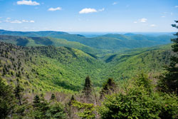
Rusk Mountain Wild Forest
&
Hunter West Kill Wilderness Area |
 |
| Click here to see a larger and more complete map |
| |
| |
|
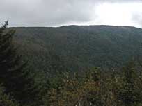
Balsam Mountain in Greene County - ~5 miles round trip - 4.5 hours in Winter, less in the summer. BUSHWACK Hike!. Moderate difficulty. Limited Views in the Winter - NO views in the summer. 1,792 vertical feet climb.


|
|
| |
| |
|
Diamond Notch Carriage Road - 5.37 miles round trip - 2.75 hours. Easy. Nice easy walk over Diamond Notch. Limited Views. 582 vertical feet climb on West side, and 885 vertical feet climb on the East side.


|
|
| |
| |
|
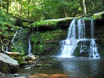
Hunter Mountain Loop - 8.16 mile trip - 5.75 hours. Moderate. Nice easy walk on the North side and Moderate walk on South side. Restored fire tower and Ranger Station at summit. Great views from the fire tower.


|
|
| |
| |
|
|
Hunter Mountain from Becker Hollow - 5.40 mile trip - 4.50 hours. Difficult. Starts off easy for the first 1/2 mile. Then becomes a moderate hike for the next 1.5 miles. Then becomes more difficult for the last 1/2 mile. The Summit Loop Trail is very nice and enjoyable. Restored fire tower and Ranger Station at summit. Great views from the fire tower. Great views a little way down the trail

|
|
| |
| |
|
|
Hunter Mountain from Notch Lake off Rt 214 - 8.02 mile trip - 5.50 hours. Difficult. Starts off difficult for the first 1/2 mile. Steep and rocky. Then becomes a easy to moderate for the rest of the hike. Restored fire tower and Ranger Station at summit. Great views from the fire tower.
|
|
| |
| |
|
Leavitt's Peak - 7.07 mile trip - 5.75 hours. Moderate. Encounter Buttermilk Falls and Geiger Point (ledge). Beautiful and peaceful walk along the top of Leavitt's Peak. This hike is often done to satisfy the requirements of the 3500 club. There are very few views from the mountain. But, the walk towards the summit is excellent.
|
|
| |
| |
|
North Dome & Sherrill Mountain - 9.50 mile trip - 6.00 hours. Difficult. This is a BUSHWACK HIKE. There are NO trails to the top. There are limited views. This is an difficult bushwack hike to the summit. This hike has a lot of ledges you will need to scramble up.
|
|
| |
| |
|
Rusk Mountain - 3.66 mile trip - 2 hours. Moderate. This is a BUSHWACK HIKE. There are NO trails to the top. There are limited views. This is an moderately easy hike, and fairly easy to follow bushwack hike to the summit. Going beyond the summit are the Big Ledges with awesome views.
|
|
| |
| |
|
Sherrill Mountain - 5.75 mile trip - 4.50 hours. Moderate. This is a BUSHWACK HIKE. There are NO trails to the top. There are limited views. This is an moderately easy hike, and fairly easy to follow bushwack hike to the summit. There are some interesting points during the hike.
|
|
| |
| |
|
West Kill Mountain - 6.40 mile trip - 4.50 hours. Difficult hike to summit of West Kill Mountain. One of the best views in the Catskill Mountains from two vantage points.

|
|
| |
| |
|
|
St-Anne & West Kill Mountain - 9.39 mile trip - 6-7 hours. Difficult hike to summit of West Kill Mountain. One of the best views in the Catskill Mountains from two vantage points.
|
|
| |
| |