|
Information about Kaaterskill Falls: |
| Name: Kaaterskill Falls |
| County: Greene |
| Region: North-South Lake |
| Location: Lake Creek Ravine |
| Order within ravine: 1st of 2 waterfalls (1=highest elevation) |
| Drops within waterfall: 2 |
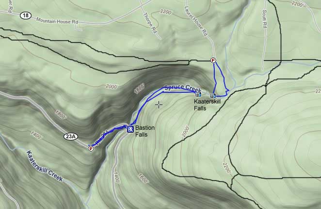
| Parking Lots (Lower - Rt 23a): One before Bastion Falls AND one after Bastion Falls (almost always full) |
| Parking Lots (Upper - Rt 18): One at the end of Laurel House Road (often full) Take North Lake Road (Rt 18) in Haines Falls |
| Parking Lots (Upper - Rt 18): One at the top of Scutt Road (rarely full) Take North Lake Road (Rt 18) in Haines Falls |
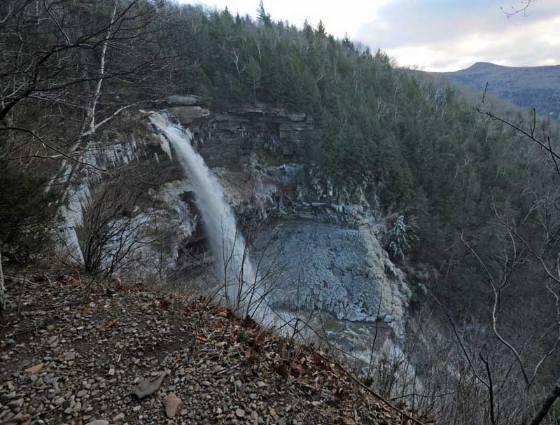
| Total Height: 231' (measured by DEC with a laser) |
| Top Elevation: 2,360' |
| Bottom Elevation: 2,129' |
| Type of Waterfall: Plunge |
| Number of Drops: 2 |
| GPS location: N 42.19311, W 74.06287 (Top of falls) |
| WGS84 location: 42.1933, -74.06296 (Top of falls) |
| Deg, Min, Sec location: N42 11 35, W74 03 46 (Top of falls) |
| UTM location: 18N 577368, 4671663 (Top of falls) |
| Previous or Alternate Names: Catterskill Falls, Cauterskill Falls |
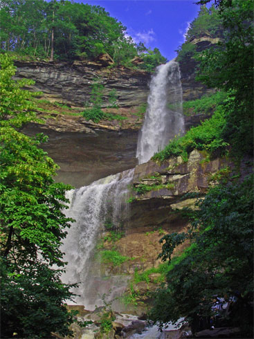
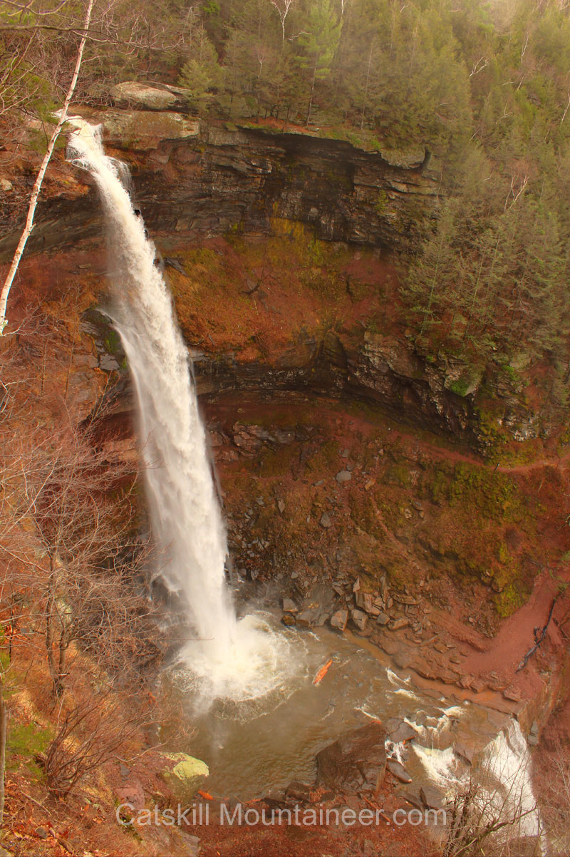
| Description: This waterfall consist of 2 drops. The first drop is 167' and the second drop is 64' high |
| Hiking Distance: ~1.8 miles (round trip). |
| Best time to Visit: After a large rain storm (4-5" of rain) and in the late afternoon |
| Trail Information: Hiking Kaaterskill Falls |
| Time: Average 1 hours round trip |
| Elevation Gain: 330' from Rt 23a to the base of Kaaterskill Falls. |
| Elevation Loss: 50' from Laurel House Road to the top of Kaaterskill Falls. |
| Difficulty: Easy |
| Access to top of waterfalls: Hike down from Laurel House Road |
| Access to bottom of waterfalls: Hike up from Rt 23a by the horseshoe in the road by Bastion Falls |
| |
Digital Mapper:
Topo
Terrain
Satellite
| |
| Trail Map : DEC-Trail-Map (pdf) |
| |
| Region Info : Kaaterskill Wild Forest Info |
| |
| Known Access Safety: Over 200+ deaths over the past 200 years. Considered one the most deadly waterfalls in the world. |
| Known Access Safety: There are many ways to die at Kaaterskill Falls - Here are just a few warnings: |
| Known Access Safety: Most Deaths occur from falling off the top of the falls or being washed over the falls. |
| Known Access Safety: Falling off the top of the lower falls |
| Known Access Safety: Not safe to rock climb - rock crumbles |
| Known Access Safety: Do NOT cross creek when the water is high, and do not cross near the top of either falls |
| Known Access Safety: Stay on the trails. |
| Access Methods: Hike from Rt 23a to access the bottom. Hike from Laurel House Road to get to the top. Do NOT climb up the closed trail from the base of the falls to the top. Very dangerous. |
|
|
Maps, Profile, and GPS files |
 |
|
|
Directions to Trail Head to the Bottom of Kaaterskill Falls from the NYS Thruway |
| Take New York State Thruway to Exit 21 (Catskill). |
| Take a left out of the NYS Thruway entrance road. |
| Go approximately 1/4 mile |
| Take a right onto Route 23 West |
| Go approximately 6.6 miles to Cairo, NY |
| Take a LEFT onto Rt 32. McDonalds Rest. on corner. |
| Go approximately 7.7 miles on Rt 32 |
| Take a RIGHT onto Rt 23A |
| Go approximately 5.7 miles on Rt 23A . |
| After going around the Horseshoe turn (by Bastion Falls), park 1/4 mile past the Falls at Rip's Lookout. |
|
Directions to Trail Head to the Top of Kaaterskill Falls from the NYS Thruway |
| Take New York State Thruway to Exit 21 (Catskill). |
| Take a left out of the NYS Thruway entrance road. |
| Go approximately 1/4 mile |
| Take a right onto Route 23 West |
| Go approximately 6.6 miles to Cairo, NY |
| Take a LEFT onto Rt 32. McDonalds Rest. on corner. |
| Go approximately 7.7 miles on Rt 32 |
| Take a RIGHT onto Rt 23A |
| Go approximately 6.6 miles on Rt 23A . |
| Climb up the windy mountain road (Rt 23A). When you reach the top, you will then be in Haines Falls. |
| Take a RIGHT onto North Lake Road. (Brown DEC sign on corner) |
| Follow North Lake Road until you reach Laurel House Road on the RIGHT side of the road. |
| Take a RIGHT onto Laurel House Road. |
| Go to the end of Laurel House Road and park at the turn-around. |
| Note: If you want to cross Lake Creek at high water, you will need to go further down North Lake Road to Scutt Road to get to the other side of Lake Creek. |
|
Comments about this Hike |
Kaaterskill Falls is the most popular trail hiked in the Catskill Mountains. On a weekend, thousands of people line the road to hike up to the base of Kaaterskill Falls. Usually, Lake Creek is at low water, and the view is disappointing. But, at high water you will see the same view as the pictures displayed below. High water usually comes after 4-5 inches of rain. The best photo opportunity is usually later in the day. The sun will shine up the Lake Creek Ravine later in the day. The upper part of Kaaterskill Falls is 167' high and the lower part of Kaaterskill Falls is 64' high. The most awesome view is from the base of the waterfall.
Years ago there was a trail that went from the base of Kaaterskill Falls to the basin and to the top of Kaaterskill Falls. But, due to accidents and deaths, the trail was closed. Many people still use the paths, but they are dangerous. You can get to the top of Kaaterskill Falls by driving up to North Lake Road and taking Laurel House Road. There is a very short trail down to the top of Kaaterskill Falls.
To get some of the spectacular photos, we used a rope and harness to safely get some of these photos. I cannot over-emphasize the need to be safe. The number of deaths at Kaaterskill Falls is staggering. If you fall off the top of Kaaterskill Falls, the probability of surviving is virtually zero. Only one person has survived a fall over 200 years. Some years we get 4-5 deaths. Always keep safety as your number one priority. |
|
Mile Post Chart for Trail to the Top of Kaaterskill Falls |
| Mile Post | Altitude | Notes |
| 0.00 | 2,360 | Parking Lot on Laurel House Road.Take trail/road that has a metal gate blocking road/trail |
| 0.22 | 2,212' | Walk down the trail until the trail ends at the top of Kaaterskill Falls. |
| 0.44 | 2,212' | Return back to parking lot the same way you came. |
Mile Post Chart for Trail to the Bottom of Kaaterskill Falls |
| Mile Post | Altitude | Notes |
| 0.00 | 1,700 | Parking Lot on Route 23A (above and past Bastion Falls - past Horseshoe turn over bridge). Walk down Route 23a to bridge running over Spruce Creek (just below Bastion Falls). When you walk down Route 23a, stay on the other side of the guard rails to avoid being hit by a car. Respect car traffic. |
| 0.22 | 1,645 | After walking over bridge, Take a LEFT and walk up the right side of Spruce Creek. |
| 0.68 | 1,969' | After walking 0.46 miles up the trail, you will come to the base of Kaaterskill Falls. |
| 1.36 | 1,700' | Return back to Rip's Lookout on the same path. |
|
Pictures of Kaaterskill Falls |
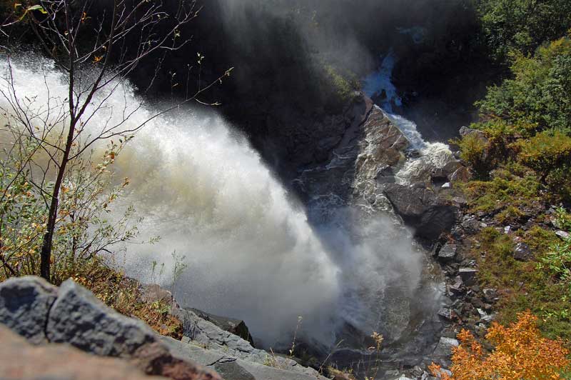 |
View from the top of Kaaterskill Falls looking over - Photo taken with a rope & harness.
Photo by Richard Kugel |
 |
View from the top of Kaaterskill Falls
Photo by Catskill Mountaineer |
 |
Top of Kaaterskill Falls.
Photo by Richard Kugel |
 |
View from the rim of Kaaterskill Falls in early Winter - Photo taken with a rope & harness.
Photo by Richard Kugel |
 |
View from the rim of Kaaterskill Falls - Photo taken with a rope & harness.
Photo by Richard Kugel |
 |
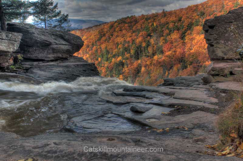
View from the viewing platform at the top of Kaaterskill Falls
Taken the 1st day the Viewing Platform was opened.
Photo by Catskill Mountaineer |
 |
View from the base of Kaaterskill Falls.
Photo by Catskill Mountaineer |
 |
View from the base of Kaaterskill Falls.
Photo by Catskill Mountaineer |
 |
View from behind Kaaterskill Falls. "Under the Falls" by Winslow Homer (Brooklyn Museum)
Historic Photo from Library of Congress |
 |
View of Kaaterskill Falls back in the late 1800's.
Historic Photo by Library of Congress |
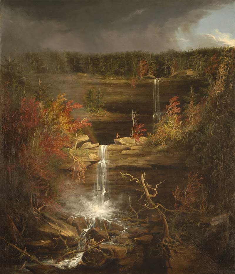 |
Kaaterskill Falls Painting by Thomas Cole.
Painting by Thomas Cole |
 |
Kaaterskill Falls Painting by Thomas Cole.
Painting by Thomas Cole |
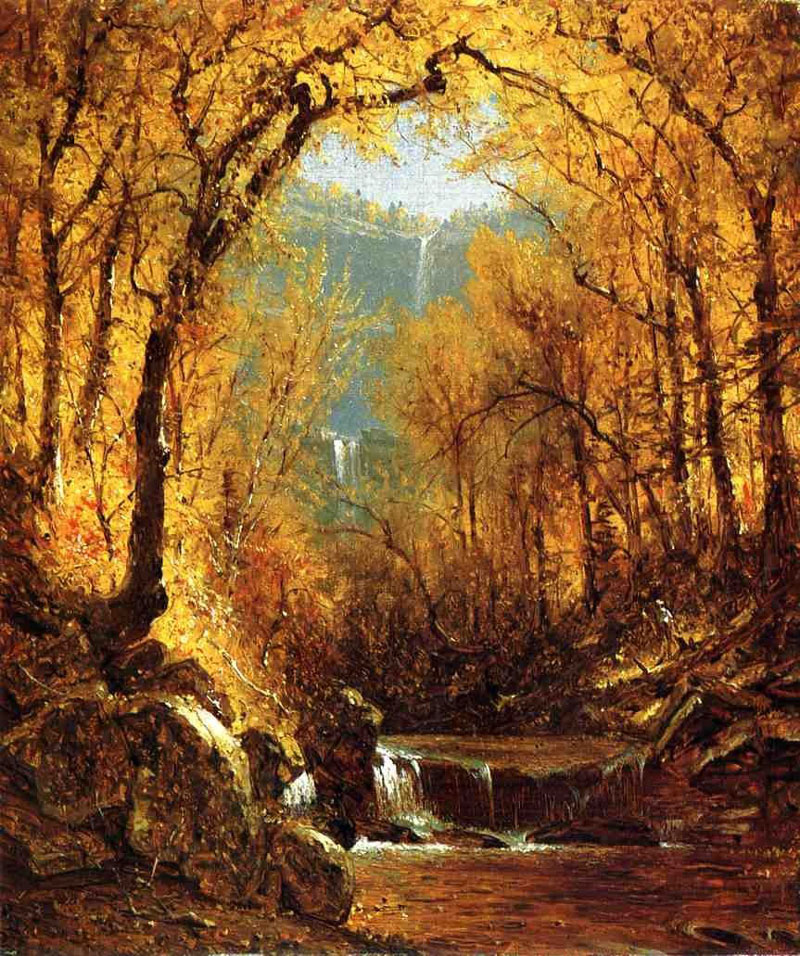 |
Kaaterskill Falls Painting by Stanford Robinson Gifford.
Painting by Stanford Robinson Gifford |
 |
View of Kaaterskill Falls from the base.
Historic Photo by Detroit Publishing Co - 1902. |
 |
View of the basin of drop #1 of Kaaterskill Falls.
Historic Photo by Detroit Publishing Co - 1902 |
 |
View of Kaaterskill Falls from the Prospect Ledge (now overgrown).
Historic Photo - Author Unknown |
 |
View of Kaaterskill Falls from the Rail Road Tracks.
Historic Photo - Author Unknown |
 |
Dog Monument on the wall of Kaaterskill Falls.
Photo - Catskill Mountaineer
Out of 200+ deaths over the past 200 years, One person and two dogs have survived the fall off the upper falls. |
|
IH
|
S E C T I O N S
|
W E A T H E R
|
O T H E R
|
|