KHP via South (blue) Trail
Posted: Wed Dec 28, 2011 8:46 pm
Kaaterskill High Peak 26Dec2011
I had 5 objectives, two peaks, two crashes and a fort. Between one of the shortest days of the year, some route finding problems at the beginning, and about 6 inches of fresh snow at elevation, I settled for two. One peak, one crash. The new snow was down to the car. There was wind, it was never an issue.
I seen both of them from doing the Devils Path three years ago and wanted to go.
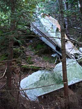
I’d finally accepted I’d need to take a section of the Long Path and perhaps even do the Peak from the easy side, when I ran into the Mohican Chapter of ADK. They knew the ‘whack to the crash and the snowmobile route to the steep face. There, we ran into two other guys who guided us straight to the top following the blue markers. In the fresh snow, we only saw a fragment of airplane wing, presumbably from the upper crash.
I spent some time looking for the second crash site and then left. I took a route straight down to the car at the Devils Kitchen.
In retrospect, I see I’d assumed this would be like the last two peaks I’d whacked - Friday and Balsam Cap last month. That I would clearly see where they were at points along the way. But much of the KHP area is in evergreen. Short ones like Christmas trees that obscure visibility. I couldn't see the mountain until about the plane crash though I knew in which direction it was.
Lower Plane Wreck

View of Devils Path

Plane Fragment at summit

I had 5 objectives, two peaks, two crashes and a fort. Between one of the shortest days of the year, some route finding problems at the beginning, and about 6 inches of fresh snow at elevation, I settled for two. One peak, one crash. The new snow was down to the car. There was wind, it was never an issue.
I seen both of them from doing the Devils Path three years ago and wanted to go.
I’d finally accepted I’d need to take a section of the Long Path and perhaps even do the Peak from the easy side, when I ran into the Mohican Chapter of ADK. They knew the ‘whack to the crash and the snowmobile route to the steep face. There, we ran into two other guys who guided us straight to the top following the blue markers. In the fresh snow, we only saw a fragment of airplane wing, presumbably from the upper crash.
I spent some time looking for the second crash site and then left. I took a route straight down to the car at the Devils Kitchen.
In retrospect, I see I’d assumed this would be like the last two peaks I’d whacked - Friday and Balsam Cap last month. That I would clearly see where they were at points along the way. But much of the KHP area is in evergreen. Short ones like Christmas trees that obscure visibility. I couldn't see the mountain until about the plane crash though I knew in which direction it was.
Lower Plane Wreck
View of Devils Path
Plane Fragment at summit