Hike Mount Guardian |
 |
| View Point on the Mount Guardian Trail |
| |
|
OVERVIEW |
| | Distance: | 3.38 miles round trip for Guardian Mtn Summit. |
| | Time: | Average 3.50 hours round trip |
| | Elevation Gain: | 1,024 feet from parking lot to Mt Guardian Summit. |
| | Best Time to Hike: | Fall & Spring. |
| | Difficulty: | Moderate |
| | Peak Elevation: | 2,084' |
| | Forest: | Mount Guardian Preserve & Private Land |
| | |
| | | USGS Official Names: | Mount Guardian |
| | Alternate Names: | Guardian Mountain |
| | Summit-Elevation: | 2,084' |
| | Guardian-Summit-WGS84: | 42.06845, -74.132167 (DEC-WGS84) |
| | Guardian-Summit-GPS: | N 42 04.107, W 74 07.930 (GPS) |
| | Guardian-Summit-UTM: | 18N 571795 4657741 (UTM) |
| | Guardian-Summit-Deg, Min, Sec: | N42 04 06, W74 07 55 (Degree, Min, Sec) |
| | |
| | | USGS Official Map: | Bearsville Topographical Map (free) |
| | |
| | | Digital Mapper: |
Topo
Terrain
Satellite |
| | |
| | | Notice: |
Rattlesnakes (Low) |
| | Access Methods: | Foot and snowshoe. |
|
|
Map for the Hike of Mount Guardian |
 |
| Cartographer Notes: GPS tracks & waypoints on map are seeded to comply with USC Title 17 Section 101 & 117 |
|
|
| | DIRECTIONS TO TRAIL HEAD |
| | DEC Parking Lot WGS84 (DEC): 42.0559, -74.13925 - Elevation is approximately 1,058 feet |
| | DEC Parking Lot Deg/Min/Sec: N42 03 21, W74 08 21 - Elevation is approximately 1,058 feet |
| | DEC Parking Lot GPS: N 42 03.354, W 74 08.355 - Elevation is approximately 1,058 feet |
| | DEC Parking Lot UTM: 18N 571223 4656341 - Elevation is approximately 1,058 feet |
| | Take New York State Thruway to Exit 20 (Saugerties). |
| | Take a LEFT out of the NYS Thruway entrance road.
|
| | (IF you came SOUTH on the Thruway)
| | Take a RIGHT onto Route 212 West |
| | Go approximately 8.8 on Rt 212 to Woodstock, NY
|
| | (IF you came NORTH on the Thruway) |
| | Go approximately 9.1 on Rt 212 to Woodstock, NY
|
| | When you come into the center of the village take a RIGHT onto Rock City Road. |
| | Go approximately 0.6 miles on Rock City Road. |
| | At the 4-way Stop sign - Turn LEFT onto Glasco Turnpike (Rt 32). |
| | Go approximately 0.6 miles on Glasco Turnpike. |
| | Turn RIGHT onto Upper Byrdcliffe Road. |
| | Go approximately 0.9 miles on Upper Byrdcliffe Road. |
| | Turn Right into the Byrdcliffe Theater Parking Area (LEFT side of building) |
| | NOTE: If the first parking lot is full, there is a parking area on the right side of the build (across driveway). |
|
|
|
NOTES ABOUT THIS HIKE |
| | RATTLESAKES: Overlook Mountain has the highest population of Timber Rattlesnakes in the Catskill Mountains. Most are found near the summit of Overlook Mountain. Rattlesnakes rarely cross asphalt roads. While it is unlikely that they exist on Mt Guardian, it does not mean that they can never be found on Mt Guardian. Adult Timber Rattlesnakes are a very calm snake, unless you step on them. Often times they will not rattle when you are close to them. Baby rattlesnakes are very nervous are considered more dangerous. If you encounter one, hike around it, and leave it alone.
LAND: The Byrdcliffe Trail and a small part of the Mount Guardian Trail are privately owned. You are allowed to hike on the trail. Once you get about a 1/2 mile up the trail, the land turns into the Mount Guardian Preserve, which is owned by the Woodstock Land Conservancy. The rules of hiking on NY State land also exist on the hike, along with the following additional rules: (1) No Camping; (2) No motorized vehicles; (3) No Fires
TRAILS: The lower parts of both trails have Yellow Trail Markers, either painted on the trees, or have DEC Trail Markers (Nature Trail). The upper parts of the trail have NO trail markers, and some route finding is necessary. Especially, the trail above the View Point. The closer you get to the summit, the more difficulty that hikers have following the trail. You can take a picture of our map to help you. There is also cellphone reception on the trail. |
|
|
MILEAGE CHART for the hike of MOUNT GUARDIAN |
| |
| |
Mileage |
Mile Point |
Altitude |
Description |
| |
| |
| | 0.00 | 0.00 | 1,058' | Byrdcliffe Theater Parking Lot |
| |
| | 0.45 | 0.45 | 1,301' | Trail Junction (trail to Camden Road) |
| |
| | 0.91 | 0.46 | 2,922' | Old Bluestone Quarry |
| |
| | 0.98 | 0.07 | 1,650' | Turn left by rock |
| |
| | 1.26 | 0.28 | 3,130' | Trail Junction (view Point) |
| |
| | 1.69 | 0.43 | 3,130' | Summit of Mount Guardian |
|
 |
This is the Parking Areas for this hike. The building you see in the picture is the Byrdcliffe Theater. The alternate parking area is in the far right of the picture where you see the car parked.
The trailhead for the hike is towards the left side of the parking area. There is a kiosk near the white propane tank. |
|
 |
 |
This is the trailhead for the Byrdcliffe Trail. It is located towards the left side of the parking area. |
All the rules of the NYS Trails exist with additional rules of No camping, no motor vehicles, No fires. You must stay on the trail for the first 1/2 of a mile (private land). The land during the first 1/2 mile is owned by the Woodstock Craftsman, and is private property, so please stay on the trail. After a 1/2 mile the land is owned by the Town of Woodstock. |
|
 |
 |
At the beginning of the hike, you will cross over two driveways. |
Then the trail will be pretty easy to follow after climbing uphill for a short period. |
|
 |
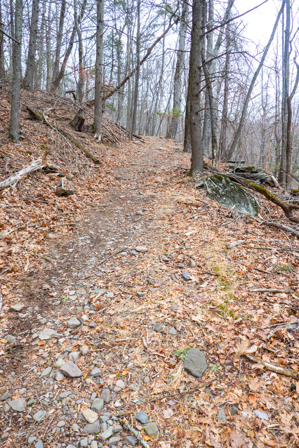 |
After hiking up the Brydcliffe Trail for about 0.45 miles, you will come to a Trail Junction. You want to go LEFT onto the Mount Guardian Trail to the summit of Mount Guardian. |
The trail will go uphill for a while. After about 500 feet you will enter the Mount Guardian Preserve. It is owned by the Woodstock Land Conservancy. At this point you are allow to leave the trail. |
|
 |
 |
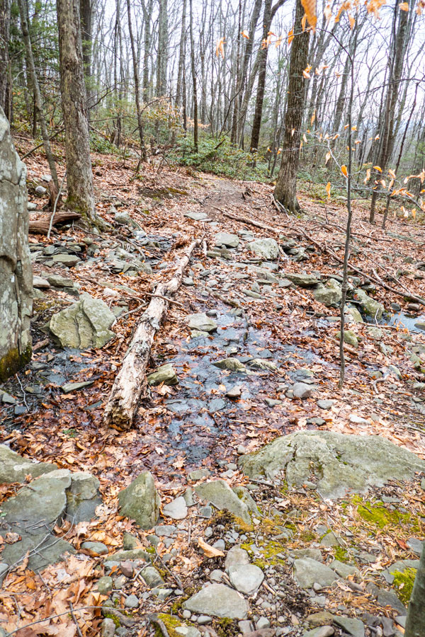
You will have a small stream crossing. Most of the time the stream is a shallow flow of water. After a rain storm, there is a nice waterfall directly below the trail. |
As you move up the trail, you will start to see more Mountain Laurel that most hikers dislike. |
|
 |
Once you are on Preserve land, you will see some of these NYS DEC Trail Markers. Unfortunately, they stop part way up the mountain where they are needed the most. |
|
Many Hikers Get Lost Here! |
 |
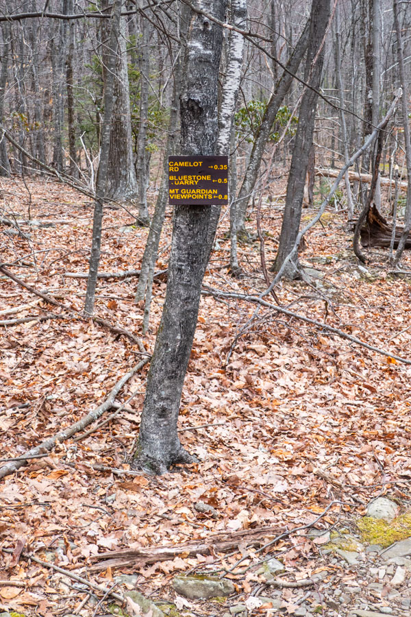
YOU WANT TO GO LEFT when you reach the rock. The correct trail is narrow because so many people get lost here. So, pay attention. This is located 250' past the small bluestone quarry. |
|
 |
After about 1/4 mile past the rock, you will come to another Trail Junction. The trail goes RIGHT up a steep hill. Once you get to the top of the hill go LEFT (uphill).
Straight will take you to the best view point. It is located 150' past this trail junction (see picture below). |
|
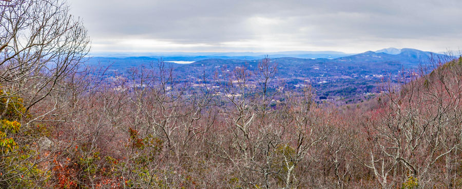 |
This is a view from top of the rock at the best view point. In the distance you can see a little bit of the Ashokan Reservoir. Once you are done, hike back to the main trail, and head uphill. |
|
 |
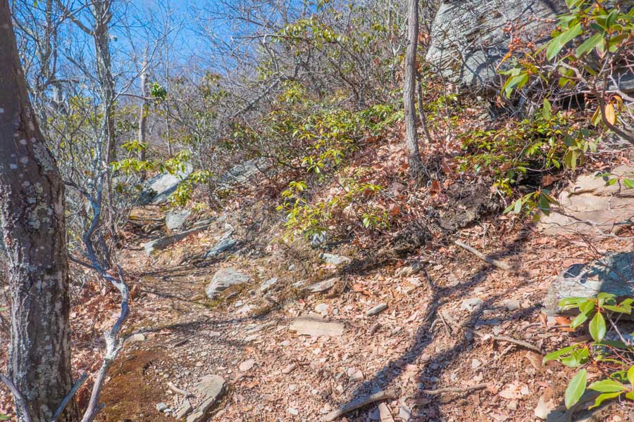
Soon, you will reach the summit region. As you can see in the picture, the trail receives very little traffic after the view point. Near the horizon, you can see the green of more Mountain Laurel. The summit is covered with Mountain Laurel. As you proceed further, you want to move to the right of the Mountain Laurel so that you are on the east side of the summit.
If you look at the map, you will see that you will actually hike past the summit region on the right side. That is where the Mountain Laurel has a number of breaks in coverage. You will actually be able to hike to the summit without having to push your way through Mountain Laurel. |
|
 |
Keep hiking along the edge of Mountain Laurel PAST the summit region. While you see a break in the Mountain Laurel on your left (of the picture), there is not a clear path forward. So keep hiking forward.
|
|
 |
 |
In this picture, you are now northeast of the summit region. You can see a clear path to the back side of the summit region. Turn LEFT and hike towards the north side of the summit region of Guardian Mountain. |
Once you are on the north side of the summit region, there is another clearing towards the summit region. Turn LEFT again, and hike towards the summit along the path most clear of Mountain Laurel. |
|
 |
As you approach the highest point, the Mountain Laurel will close in on your path. Shortly, you will see a small opening, maybe 20'x20', of grass and moss. Once there, move a little further towards the summit.
On your right, you will see the large boulder in the picture above. We consider this as the true summit of Mountain Guardian. |
|
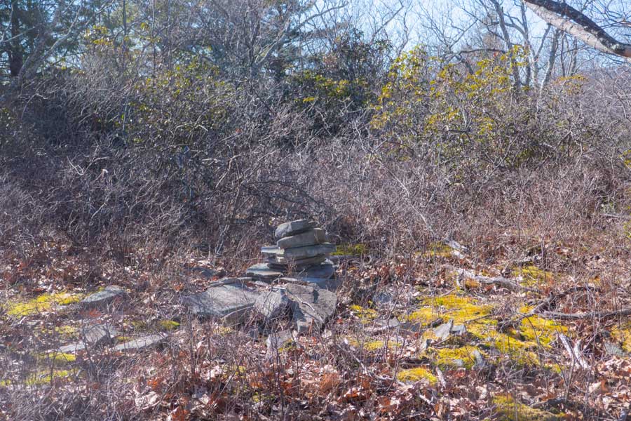 |
If you continue a little past the large summit boulder, you will come to another opening. Some maps show this as the summit.
Lidar maps show this as the summit. This is because the artifical rock cairn, created by humans, might be slightly higher then the large boulder. If we were to remove the rock cairn, it is then lower then the Boulder Rock summit. So, we consider this the false summit.
Once done visiting the summit of Mountain Guardian, you can reverse your course back to your car. Hope you had a good day! |
|
|
S E C T I O N S
|
W E A T H E R
|
O T H E R
|