Hike or Bike the Southern Region of Bluestone Wild Forest |
 |
| The Trail Head at Morey Hill Road |
| |
| |
|
OVERVIEW |
| | Type of Trails: | 100% DEC Trails |
| | Parking Area : | Jockey Hill - Southern DEC Parking Area - 5 cars - NOT plowed in Winter |
| | Parking Area : | Morey Hill Road Public Parking Area - 15 cars - NOT plowed in Winter |
| | Winter Access: | Shove a spot out on Morey Hill Road PA (bring a snow shovel). |
| | | |
| | | Trail : |  South Central Trail (From Parking Area to Private Property) South Central Trail (From Parking Area to Private Property) |
| | Trail : |  |
| | Trail : |  Suzukimoto OR Kneecap Trail Suzukimoto OR Kneecap Trail |
| | Trail : |  Groove Trail Groove Trail |
| | Trail : |  Guaniana OR Close-to-the-Edge Trail Guaniana OR Close-to-the-Edge Trail |
| | Trail : |  Skull Trail Skull Trail |
| | Trail : |  Mushroom Trail Mushroom Trail |
| | Trail : |  Scott's Trail Scott's Trail |
| | | |
| | | Access Methods: | Mountain Bike, Foot, ski and Snowshoe |
| | Best Time to Hike: | Anytime |
| | Best Time to Bike: | Anytime |
| | Difficulty: | Easy |
| | | |
| | | DEC Trail Map: | DEC Bluestone Wild Forest Map (free) |
| | | |
| | | Digital Mapper: |
Topo
Terrain
Satellite |
|
|
Maps for Southern Region of the Bluestone Wild Forest |
 |
 Bluestone Loop Trail (lakes) Bluestone Loop Trail (lakes) |
 Red Elf Trail(lakes) Red Elf Trail(lakes) |
 Onteora Lake Loop (lakes) Onteora Lake Loop (lakes) |
 Woods Road (Wintergreen) Woods Road (Wintergreen) |
 Turnpike Trail (lakes) Turnpike Trail (lakes) |
South Central Trail (southern) |
 Quilty Trail (Wintergreen) Quilty Trail (Wintergreen) |
 |
|
 Wintergreen Trail (Wintergreen) Wintergreen Trail (Wintergreen) |
 Pickerel Pond (lakes) Pickerel Pond (lakes) |
Suzukimoto or Kneecap Trail (southern) |
 Bear Trail (Wintergreen) Bear Trail (Wintergreen) |
 |
Groove Trail (southern) |
 Bear Connector Trail (Wintergreen) Bear Connector Trail (Wintergreen) |
 |
Guaniana or Close-to-the-Edge Trail (southern) |
 Cub Trail (Wintergreen) Cub Trail (Wintergreen) |
 Quarry Trail (lakes) Quarry Trail (lakes) |
Skull Trail (southern) |
 Meyers Road Trail (Wintergreen) Meyers Road Trail (Wintergreen) |
 Quik Loop Trail (lakes) Quik Loop Trail (lakes) |
Mushroom Trail Trail (southern) |
 Straight Shot Trail (Wintergreen) Straight Shot Trail (Wintergreen) |
 |
Scott's Trail Trail (southern) |
|
 |
| Bluestone Loop Trail (lakes) |
Red Elf Trail(lakes) |
Onteora Lake Loop (lakes) |
| Woods Road (Wintergreen) |
Turnpike Trail (lakes) |
South Central Trail (southern) |
| Quilty Trail (Wintergreen) |
|
|
| Wintergreen Trail (Wintergreen) |
Pickerel Pond (lakes) |
Suzukimoto or Kneecap Trail (southern) |
| Bear Trail (Wintergreen) |
|
Groove Trail (southern) |
| Bear Connector Trail (Wintergreen) |
|
Guaniana or Close-to-the-Edge Trail (southern) |
| Cub Trail (Wintergreen) |
Quarry Trail (lakes) |
Skull Trail (southern) |
| Meyers Road Trail (Wintergreen) |
Quik Loop Trail (lakes) |
Mushroom Trail Trail (southern) |
| Straight Shot Trail (Wintergreen) |
|
Scott's Trail Trail (southern) |
|
|
Notes About the Bluestone Wild Forest |
The way the DEC marked the trails in the Bluestone Wild Forest is very different then anywhere else in New York State. In the beginning, when there were only a few trails, they were marked with the traditional Blue, Red, and Yellow Trail Markers. When they Open Space Institute acquired more land for the Bluestone Wild Forest in June of 2020, they had to come up with another way of marking the trails.
So, the Lakes Region official color is Red. But, you will find Blue, Red, and Yellow Trail Markers. Some Trails have numbers (1 to 9) on the trail Markers.
The Southern Region would have ONLY Yellow Trail Markers with number (1-to-9) on them.
The Wintergreen Region would have ONLY Blue Trail Markers with numbers (1-to-9) on them. But, recently they started to mix colors in the Wintergreen Region.
All the trails now have names, and most people just look for the Trail Name. It is a little confusing, but the Trail Name seems to work best. But, some people use both the Trail Marker color/number and/or the Trail Name.
|
Notes About the Southern Region of the Bluestone Wild Forest |
In Early 2023, there has been significant work on fixing and hardening some of the trails in the Southern Region. This involves heavy equipment (miniature excavator). Some trails were temporarily closed to hikers and mountain bikers. The Bluestone Wild Forest has been growing significantly in the past few years. We expect this to continue.
| Parking Areas the Bluestone Wild Forest |
Onteora Lake - DEC Outer Parking Area Holds 30 cars. Plowed in Winter. 41.9815, -74.085567
Onteora Lake - DEC Inner Parking Area Holds 15 cars. Not plowed in Winter. 41.984033, -74.0829
Morey Hill Road - Public Roadside Parking Area Holds 15 cars. NOT plowed. 41.9743, -74.0685
Morey Hill Road - DEC Parking by Gate to Quarry Road Holds 1 car. Not plowed in the Winter. 41.9803, -74.065267
Jockey Hill Road - DEC Parking Area Holds 5 cars. Do NOT block gate. Not plowed in the Winter. 41.97605, -74.04875
|
|
|
| | Directions to Jockey Hill - Wintergreen DEC Parking Area from Exit 19 Kingston |
| | Jockey Hill - Southern DEC Parking Area WGS84 (DEC): 41.97605, -74.04875 - Elevation is about 488 feet |
| | Jockey Hill - Southern DEC Parking Area Deg/Min/Sec: N41 58 33, W74 02 55 - Elevation is about 488 feet |
| | Jockey Hill - Southern DEC Parking Area GPS: N 41 58.563, W 74 02.925 - Elevation is about 488 feet |
| | Jockey Hill - Southern DEC Parking Area UTM: 18N 578810 4647555 - Elevation is about 488 feet |
| |
|
| | Take New York State Thruway to Exit 19 (Kingston). |
| | Take a RIGHT out of the NYS Thruway to Route 28 West. |
| | Go approximately 0.6 miles on Rt 28 West |
| | Take a RIGHT on to exit ramp for Rt 209 NORTH |
| | Go approximately 2.1 miles on Rt 209 North |
| | Take a RIGHT on to exit ramp for Sawkill Road |
| | Take a LEFT at end of exit ramp onto Sawkill Road |
| | Go approximately 2.6 miles on Sawkill Road |
| | Take a LEFT onto Jockey Hill Road |
| | Go approximately 0.9 miles on Jockey Hill Road (30 MPH speed limit) |
| | At the end of the PAVED portion of Jockey Hill Road - go down the dirt road (Woods Road) |
| | NOTE: Woods Road (unpaved) is on the LEFT of the telephone pole |
| | NOTE: At a certain point you will see "NO TRESSPASSING" signs - IGNORE them and continue down the dirt road |
| | Go approximately 0.7 miles on Woods Road (dirt road - unpaved) |
| | when you come to a Yellow DEC gate there are 5 parking spaces |
| | NOTE: You CANNOT park anywhere on Woods Road (dirt) until you reach DEC land - Do NOT block road! |
|
|
| | Directions to MOREY HILL ROAD - PARKING AREAS from Exit 19 (Kingston) |
| | Morey Hill Road Parking Area WGS84 (DEC): 41.9743, -74.0685 - Elevation is about 499 feet |
| | Morey Hill Road Parking Area Deg/Min/Sec: N41 58 27, W74 04 06 - Elevation is about 499 feet |
| | Morey Hill Road Parking Area GPS: N 41 58.458, W 74 04.110 - Elevation is about 499 feet |
| | Morey Hill Road Parking Area UTM: 18N 577176 4647342 - Elevation is about 499 feet |
| |
|
| | Take New York State Thruway to Exit 19 (Kingston). |
| | Take a RIGHT out of the NYS Thruway to Route 28 West. |
| | Go approximately 3.0 miles on Rt 28 West |
| | Take a RIGHT into Morey Hill Road (easy to miss, so pay attention) |
| | Go approximately 0.3 miles on Morey Hill Road to Roadside Parking Area on left side of road |
| | |
| | There is a single parking space by the DEC gate 0.4 mile further on LEFT side of road (hard to find) |
|
|
|
Hike or Bike the Southern Region of the Bluestone Wild Forest |
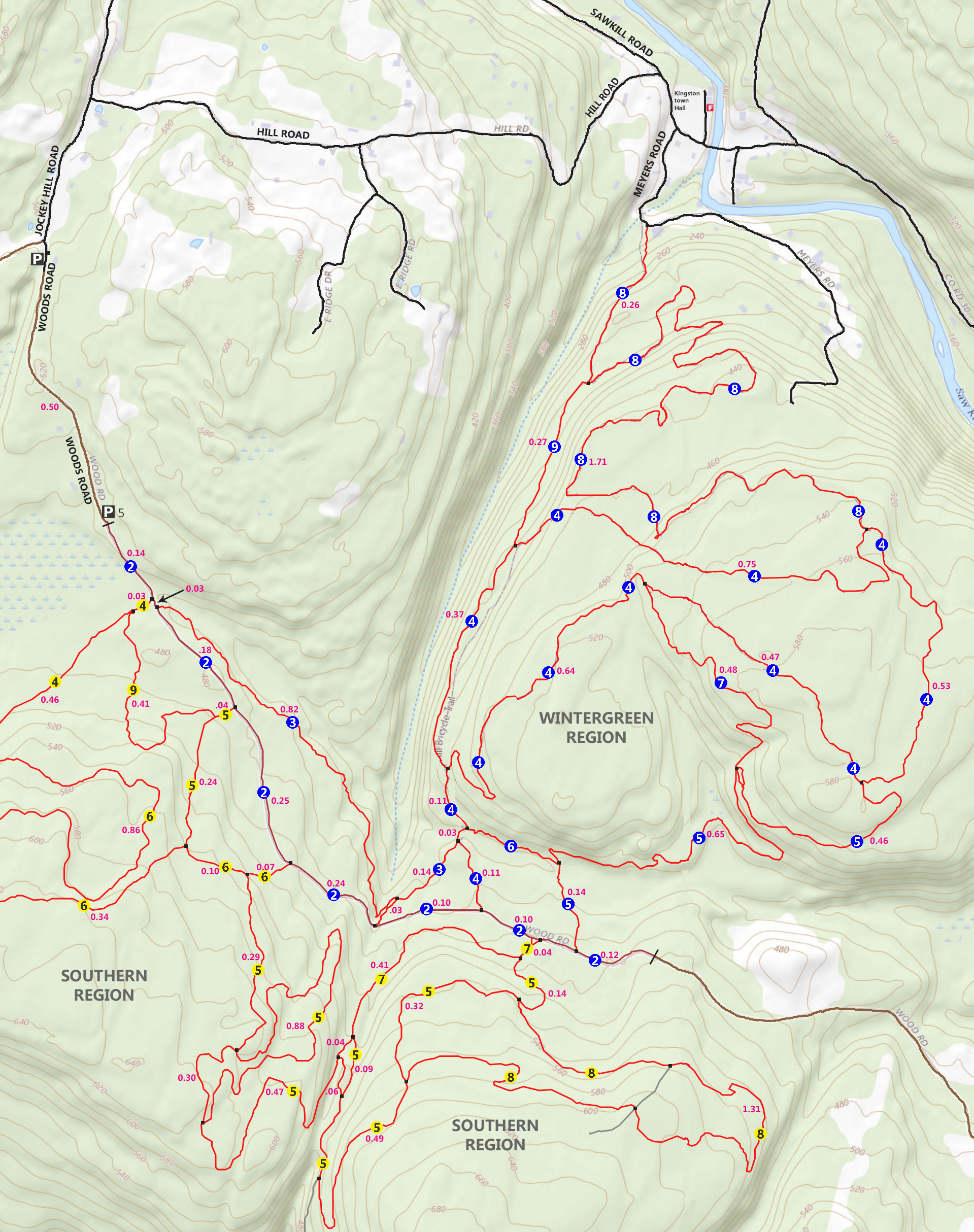
SOUTH CENTRAL TRAIL |
 |
This trail head starts about 1/4 mile up Morey Hill Road from the Parking Area. The Trail Head is on the RIGHT side of the road. There is a sign and the trail is marked with Yellow #2 Trail Markers.
The South Central Trail is 1.62 miles (not including the walk from the Parking Area to the Trail Head)
The trail gets you from Morey Hill Road to Jockey Hill Road with some nice terrain a forest along the way.
|
|
|
This is the DEC sign that represents the Jockey Hill - Southern DEC Parking Area. DEC land actually starts about 500' up the road. Look for the square metal sign with the DEC logo on it.
|
|
 |
This is an example of the South Central Trail in the Southern Region of the Bluestone Wild Forest.
Another example (on the right) of the South Central Trail in the Southern Region of the Bluestone Wild Forest
Along the way you will see a trail junction for an adventure that goes a little north and then empties onto the Jockey Hill Road
 |
|
|
 |
As you continue further on the South Central Trail, the terrain is very similar.
After 6/10 of a mile, you will come to a second trail junction. Left will take you to Jockey Hill Road. From there you can take a right and head down Jockey Hill Road to the next section of the Southern Region.
Taking a Right at the second trail junction will put you on the Suzukimoto Trail. In a 1/2 mile, you will come to the Jockey Hill Road. Continue across Jockey Hill Road go another 1/4 mile.
|
|
|
SUZUKIMOTO & KNEECAP TRAIL |
 |
The Suzukimoto Trail flows into the Kneecap Trail, and both trails share the Yellow #4 Trail Marker. Most people do not even realize they have switched from one to the other. Not sure why they have different names. They seem like one trail.
The Suzukimoto Trail Starts near the end of South Central Trail. Just west of the Jockey Hill Road (dirt road that is closed to the public). And, the Suzukimoto Trail ends just east of Jockey Hill Road. But, the trail continues with a different name, "Kneecap Trail".
The Kneecap Trail starts at the end of the Kneecap Trail (just east of Jockey Hill Road) and makes a fairly straight line to Woods Road. The Kneecap Trail ends at Woods Road, and 0.14 miles from the Jockey Hill - Wintergreen DEC Parking Area.
|
|
 |
This image was taken near the end of Kneecap Trail where it comes out on Woods Road.
|
|
|
GROOVE TRAIL |
 |
The Groove Trail starts about 1/3 mile from the Jockey Hill - Wintergreen DEC Parking Area. It is a very windy trail with some interesting terrain.
The Groove Trail is one of the longest trails in the Southern Region. It is 3.14 miles long.
The image above was taken from the Woods Road and is the beginning of the trail
|
|
 |
This image shows the Trail Junction of the Groove Trial and Scott's Trail. Scott's Trail is on the right.
|
|
|
GUANIANA TRAIL & CLOSE-TO-THE-EDGE TRAIL |
 |
To get to the beginning of the Guaniana Trail, you need to start on the Groove Trail off of the Woods Road. After going down the Groove Trail 0.28 miles, the Trail Head is on the RIGHT side of the trail. The Guaniana Trail starts off by going uphill and then winding around the top of the hill before decending down to the Kneecap Trail. As soon as you get to the Kneecap Trail, keep going across the Kneecap trail. The Trail name changes from Guaniana Trail to Close-to-the-Edge Trail.
The Guaniana Trial is 1.20 miles long and the Close-to-the-Edge Trail is 0.67 miles long.
NOTE: The Close-to-the-Edge trail is actually on the very edge of a very steep bank. You should NOT take this trail when it is icy or snow is on the trail.
|
|
 |
This image shows an example of the Guaniana Trail.
|
|
|
SKULL TRAIL
 |
The Skull Trail starts at Woods Road. The Trail Head is 0.97 miles from the Jockey Hill - Wintergreen DEC Parking Area.
The trail provides a shorter way to get to the Groove Trail.
The Skull Trail is 0.44 miles long.
|
|
|
 |
An example of the Skull Trail. The trail is fairly straight and does not have any windy parts to it.
|
|
|
MUSHROOM TRAIL |
 |
To get to the Mushroom Trail from the Jockey Hill - Wintergreen DEC parking area, you need to go down the Woods Road 0.97 miles. Take a RIGHT onto the Skull Trail. Then after 250' take a LEFT onto the Groove Trail. Go 0.14 miles until you reach the trail junction for the Mushroom Trail.
The Mushroom Trail is 1.31 miles long. The terrain is mainly flat, smooth, and straight.
There is also an non-maintained trail tha cuts across to the other side of the Mushroom Trail. There are several trees across the non-maintained trail. So, most Mountain Bikers avoid the non-maintained trail.
 | |
|
 |
This image shows what the the Mushroom Trail looks like.
|
|
 |
The trail levels out about a quarter way down the trail. The other side of the trail is fairly straight. There is one muddy spot.
At the end of the Mushroom Trail, it comes back to another place on the Groove Trail.
|
|
|
SCOTT'S TRAIL |
 |
To get to Scott's Trail from the Jockey Hill - Wintergreen DEC parking area, you need to go 0.14 miles down the Woods Road. Just after the two water drainage trenches, take a RIGHT onto Kneecap Trail. Then go down the trail 150-175'. The Trail Head is on the LEFT, with the swamp on the right.
In early 2023, the Trail Head was significantly overgrown and very difficult to find. Just remember that it is about 150' down the Kneecap Trail from Wood Road.
The image above shows the Trail Head to Scott's Trail. Hard to tell that it is a trail. Once you get on Scott's Trail, it is fairly easy to follow.
The Scott's Trail is 0.41 miles long and comes out to Groove Trail, and is only 250' away from the Woods Road.
|
|
 |
Scott's Trail is very tight and windy. So, it is slow going on a Mountain Bike.
|
|
 |
Near the end of Scott's Trail, the trail smooths out a bit.
|
|
|
|
S E C T I O N S
|
W E A T H E R
|
O T H E R
|