Catskill Mountaineer

Ashokan Reservoir Promenade

Ashokan Reservoir Promenade
View of the Slide Mountain Wilderness and from the Middle Dike of the Ashokan Reservoir


OVERVIEW

  Name: Ashokan Reservoir Promenade
  Forest: Near Bluestone Wild Forest
  Parking Area : West Side on Rt 28a - 30 spaces (DEP) - Off Rt 28
  Parking Area : East Side off Rt 28a - 20 spaces (DEP) - Directly off Rt 28a
   
  Length : 2.70 miles (one-way TH-to-TH)
  Access : Foot, Bicycle, Roller Blading.
  Views : Several
  Hours : Dawn to Dusk
  Emergency : Call 911
  Maintenance : (845) 340-3102
   
  Ulster County Map: Ashokan Reservoir Promenade Map (free)
   
  USGS Map: USGS West Kingston Quad Maps
   
  USGS Map: USGS Ashokan Quad Maps
   
  USGS Map: USGS West Shokan Quad Maps
   
  Digital Mapper: Topo     Terrain     Satellite

Maps of Ashokan Reservoir Promenade

Map of the Ashokan Reservoir Promenade DEP map

Map of the Ashokan Reservoir Promenade near the Bluestone Wild Forest

Map of the Ashokan Reservoir Promenade near the Bluestone Wild Forest


Notes about the Ashokan Reservoir Promenade

 HISTORY
  Between 1907 and 1915 the Ashokan Reservoir was constructed. The primary source of water was from the Esopus Creek. It took approximately 2 years for the reservoir to fill up. At the time, it was the largest reservoir in the world. All of the forest had to be removed, along with homes and building. Even 2,800 graves had to be removed.

The reservoir is approximately 13 miles long and over 180 feet deep. It holds 122.9 billion gallons of water. Today it supplies 40% of NYC's water.

Approximately 2,000 people in 12 communities were displaced by the construction of the reservoir. There was a tremendous amount of resistance of the people living in the region. There was a significant amount of dissent over payment of people's homes, land, and businesses. Often times, it was below fair market value. It took decades to resolve fair payment for some people's homes. Four communities were relocated along the reservoir's banks. Those four communities are Ashokan, Olivebridge, Shokan, and West Shokan. NYC did agree to provide some amenities to the public, like the water aerators, day use areas, fishing, hunting, and roads around the reservoir. After 9/11 some changes were made for security reasons.


 TRAIL
  The Ashokan Reservoir Promenade is completed paved from Eastern Trailhead to the Western Trailhead. You can use it in either direction. Most people complete the full 2.70 miles and then turn around and return back. During the 2.70 miles, you will get some of the best views possible from this route. There are views over 90% of the route. It provides a nice alterative to the Ashokan Rail Trail.


 RULES - ALLOWED USE
 
  • Running, walking, bicycling, roller blading, and wheel chairs
  • Dogs NOT allowed.
  • Organized events only allowed with DEP Special Permits
  • Hunters and Anglers (fishermen) may leave the trail only with a special permit for those activities.
  •  RULES - PROHIBITED USE
     
  • Leaving the Ashokan Reservoir Promenade area without a special permit
  • Use of motorized vehicles (electric wheel chairs are excluded from this rule)
  • Use of Kites
  • Use of illegal drugs
  • Use of alcohol
  • Use of tobacco products (including e-cigaretts)
  • Horseback riding
  • Swimming or wading in any water body
  • Camping
  • Cooking
  • Fires or stoves
  • fireworks
  • Littering, dumping trash, or leaving anything behind (LNT)
  • Operating drones
  • Removing plants, animals, or other objects
  • Commercial Activities
  • Discharging a gun across the Ashokan Reservoir Promenade
  • Shooting an arrow across the Ashokan Reservoir Promenade
  • Do not use the Ashokan Reservoir Promenade in the dark
  •  RULES - PROPER CONDUCT
     
  • Leave No Trace ("LNT")
  • What every you bring onto the Ashokan Reservoir Promenade, you must leave with
  • Do not leave with anything that you did not bring onto the Ashokan Reservoir Promenade
  • Bicyclist pass - Warn others before passing them on the left
  • Hikers and Walkers - Stay to the RIGHT of the trail so that others can pass you
  • EMERGENCIES - Call 911
  • MAINTENANCE ISSUES - Call (845) 340-3102
  • DEP POLICE - Call (845) 657-9433

  •  OTHER INFORMATION
      There is cell phone service on the Ashokan Reservoir Promenade.


    DIRECTIONS to the FRYING PAN PARKING AREA (eastern) from Exit 19 (Kingston)

     
  • Frying Pan PA (DEP) - WGS84 (DEC): 41.94745, -74.181467 - Elevation is about 622'
  •  
  • Frying Pan PA (DEP) - Deg/Min/Sec: N41 56 50, W74 10 53 - Elevation is about 622'
  •  
  • Frying Pan PA (DEP) - GPS: N 41 56.847, W 74 10.888 - Elevation is about 622'
  •  
  • Frying Pan PA (DEP) - UTM: 18N 567845 4644266- Elevation is about 622'

  •  
     
  • Get off New York State Thruway at Exit 19 (Kingston).
  •  
  • Take a RIGHT out of the NYS Thruway onto Route 28 West.
  •  
  • Go approximately 12.1 miles on Rt 28 West
  •  
  • Take a LEFT onto Reservoir Road
  •  
  • Go approximately 2.2 miles on Reservoir Road
  •  
  • Take a LEFT onto Rt 28a (east)
  •  
  • Go approximately 1.2 miles on Rt 28a
  •  
  • Take a LEFT into DEP Day Use Area Road
  •  
  • Go approximately 0.4 miles on DEP Road (West South Road)
  •  
     
  • Note: Room for 30 vehicles

  •  

    DIRECTIONS to the BOICEVILLE DAM PARKING AREA (western) from Exit 19 (Kingston)

     
  • Boiceville Dam PA (DEP) - WGS84 (DEC): 41.9339, -74.222117 - Elevation is about 606'
  •  
  • Boiceville Dam PA (DEP) - Deg/Min/Sec: N41 56 02, W74 13 19- Elevation is about 606'
  •  
  • Boiceville Dam PA (DEP) - GPS: N 41 56.034, W 74 13.327 - Elevation is about 606'
  •  
  • Boiceville Dam PA (DEP) - UTM: 18N 564489 4642730 - Elevation is about 606'

  •  
     
  • Get off New York State Thruway at Exit 19 (Kingston).
  •  
  • Take a RIGHT out of the NYS Thruway onto Route 28 West.
  •  
  • Go approximately 12.1 miles on Rt 28 West
  •  
  • Take a LEFT onto Reservoir Road
  •  
  • Go approximately 2.2 miles on Reservoir Road
  •  
  • Continue STRAIGHT (Road turns into Rt 28a (West))
  •  
  • Go approximately 1.9 miles on Rt 28a (west - Go past Rt 213)
  •  
  • Take a RIGHT into DEP Day Use Area Road
  •  
     
  • Note: Room for 20 vehicles
  •  
  • Note: Do NOT park on side of Rt 28a

  • Ashokan Reservoir Promenade

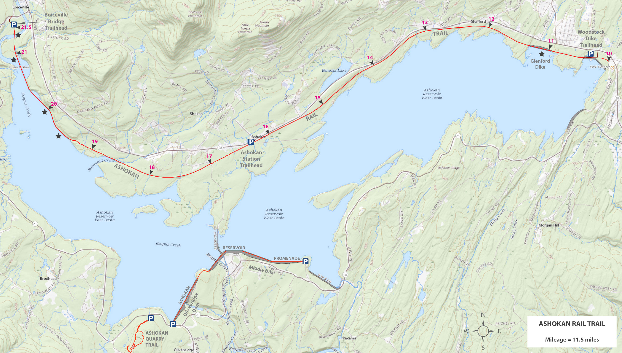
      Ashokan Reservoir Promenade - Parking Areas
    The Western Parking Area and Trailhead for the Ashokan Reservoir Promenade, called the Olivebridge Dam Parking Area
    This is the WESTERN Parking Area and Trailhead for the Ashokan Reservoir Promenade. It is called the Olivebridge Dam Parking Area. It holds about 20 cars. There are bathrooms at all Parking Areas. The access road and parking area was dirt.

    The Eastern parking area and Trailhead for the Ashokan Reservoir Promenade called the Frying Pan Parking Area
    This is the EASTERN Parking Area and Trailhead for the Ashokan Reservoir Promenade. It is called the Frying Pan Parking Area. It holds about 30 cars. There are bathrooms at all Parking Areas. This Parking Area is completely paved.

      Ashokan Reservoir Promenade - Western Section
    Balsam Cap Mountain and Samuel's Point seen from the Olivebridge Dam on the Ashokan Reservoir Promenade
    Shortly after leaving the western trail head of the Ashokan Reservoir Promenade, you will get this view on your left.

    On the far left is Balsam Cap Mountain. Below and slightly to the right of Balsam Cap Mountain is Hanover Mountain. In the center is Samuel's Point.
    Glenford Dike at mile post 11 on the Ashokan Reservoir Promenade
    After leaving the western parking area, you will pass over Olivebridge Dam. You will be heading towards the northeast. The Woodstock region is beyond the direction of the road.
    The Olivebridge Dam on the southwestern side of the Ashokan Reservoir
    About halfway, across the Olivebridge Dam on the Ashokan Reservoir Promenade, you will see the view in the image on your right side.

    The Olivebridge Dam is the location of the deepest part of the Ashokan Reservoir. It is over 180 feet deep.
    end of the Olivebridge Dam section of the Ashokan Reservoir Promenade
    In the near distance is the end of the Olivebridge Dam. When you enter land again, there is a day use area on the right.
    Ashokan Day Use Area on the Ashokan Reservoir Promenade
    On the right is the Ashokan Day Use Area. The Ashokan Reservoir Promenade does a "S" turn next to the Day Use Area.
    Western section of the Ashokan Reservoir Promenade
    This is the last section of the western side of the Ashokan Reservoir Promenade.
    Ashokan Day Use Area with water aerators seen from the Ashokan Reservoir Promenade
    On your right is another Day Use Area. Year ago, there used to be a large water aeration system. This the water is piped underground to New York City. Years ago, you could drive all the way around the Aerator. Today, that road is closed to vehicle traffic due to security concerns. You can see this from the Ashokan Reservoir Promenade.
    End of the western side of the Ashokan Reservoir Promenade
    The round blockade prevents cars from travelling on the Ashokan Reservoir Promenade. You can get past it on foot or bike.

    Do get to the Eastern side of the Ashokan Reservoir Promenade go past the round barriers and continue around the corner. You will see the eastern side branching off from the road, where it will follow the shores of the lower basin of the Ashokan Reservoir.
      Ashokan Reservoir Promenade - Eastern Section
    beginning of the eastern section of the Ashokan Reservoir Promenade
    Once you go past the round barriers on the eastern side of the Ashokan Reservoir Promenade, you will see this view on your left. This section of the Ashokan Reservoir is call the Middle Dike.
    Beginning of the Middle Dike on the eastern side of the Ashokan Reservoir Promenade
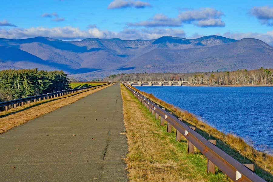
    The Eastern side of the Ashokan Reservoir Promenade has three straight sections that goes for about 1-1/4 miles.
    the second straight section of the Middle Dike of the eastern side of the Ashokan Reservoir Promenade
    This is the second straight section of the Middle Dike of the eastern side of the Ashokan Reservoir Promenade.
    This parking area on the eastern side of the Ashokan Reservoir Promenade is called the Frying Pan Parking Area
    After travelling down the third straight section of the Middle Dike of the eastern side of the Ashokan Reservoir Promenade you will come the end of the eastern section of the Ashokan Reservoir Promenade. This circular road is called the Frying Pan Parking Area.
     
    n

    Links and References:

    USGS Topo Map of the West Kingson Quad
     
    USGS Topo Map of the Ashokan Quad
     
    USGS Topo Map of the West Shokan Quad


      S E C T I O N S


      W E A T H E R


      O T H E R

    Copyright 2001-2024 www.catskillmountaineer.com ALL RIGHTS RESERVED