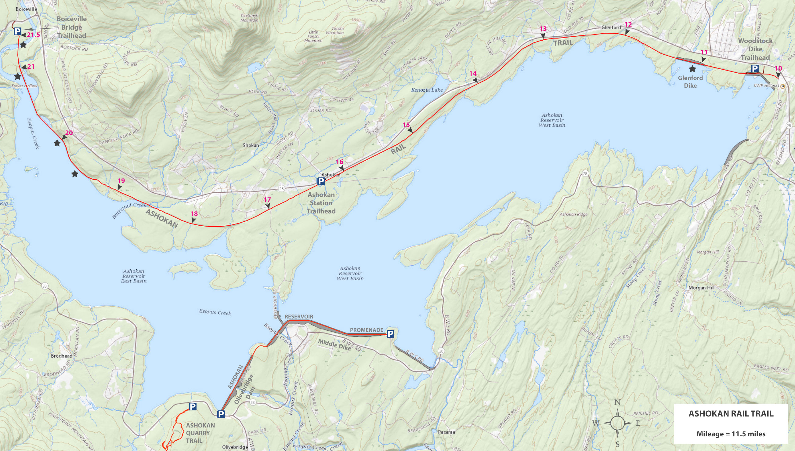
Ashokan Quarry Trail
 |
 |
This is the Ashokan Quarry Trail Parking Area and Trailhead. It is about 1/4 mile from the Olivebridge Dam Parking Area. It holds about 10 cars. The access road and parking area is dirt.
|
|
 |
This is the Trailhead for the Ashokan Quarry Trail. It is located in the Ashokan Quarry Trail Parking Area.
|
|
 |
This is the registration box for the Ashokan Quarry Trail.
|
|
 |
This is the Kiosk for the Ashokan Quarry Trail. Check it for any important information about your hike.
|
|
 |
The beginning of the hike goes up a mild uphill climb on a double-track trail.
|
|
 |
After about 3/10 of a mile you will be approaching the trail junction for the loop of the Ashokan Quarry Trail. In the picture you can see an old stone structure.
|
|
 |
At 3/10 of a mile, you will come to a trail junction. You want to continue STRAIGHT. You will come out on this trail on the left once you have completed the loop. Most people like to hike the loop in a counter-clock wise direction.
|
|
 |
As you start to approach the Yale Quarry, you will start to see quarry scrap piles.
|
|
 |
This is the Ashokan Quarry that was used to build the dikes and dams for the Ashokan Reservoir between 1907 and 1915. There was a railroad constructed to haul the bluestone to the reservoir. There are still some railroad beds in the area. We will explore that region after your visit here.
|
|
 Ashokan Quarry Trail - Quarry Loading Docks
 |
 |
 |
After you leave the Yale Quarry, the trail will continue past some towering bluestone ledges. |
After a little less then 7/10 of a mile you will come to a side trip to the Quarry Loading Docks (750'). To visit them, take a RIGHT and follow the single track trail to the quarry loading docks. |
|
 |
The trail to the Ashokan Quarry Loading Docks is designated with YELLOW Trail Markers.
|
|
 |
After about 750 feet, you will come to the Ashokan Quarry Loading Docks. They are about 10-12 feet high and wide. Beyond the Loading Docks, is the old railroad bed that comes out to Rt 28a. The official trail ends at this point.
When you get done, reverse your way back to the Ashokan Quarry Trail.
|
|
 |
This is the old Railroad bed that took the quarry rock down to the dikes and dam for building material.
|
|
 |
As you continue on the Ashokan Quarry Trail, the trail will take a 90 degree turn to the LEFT.
|
|
 |
The Ashokan Quarry Trail will then will go up some small switch backs to the top of the Yale Quarry. From this point forward, the trail will be single track trails until you reach the trail junction.
|
|
 |
The Ashokan Quarry Trail has Blue Trail Markers, with the exception of the Ashokan Quarry Loading Docks that have Yellow Trail Markers. It is important to follow the Blue Trail Markers on the top of the Quarry because it is easy to walk off the trail.
|
|
 |
The Ashokan Quarry Trail wanders aimlessly along the top of the Yale Quarry. There are a number of nice view spots. Many consider this section of the trail the best part of the hike.
|
|
 |
If you have children you want to keep them from the edge of the quarry. In a little while, you will get some mountain views.
|
|
 |
This section of the Ashokan Quarry Trail has some nice views of the mountains.
|
|
 |
This view provides nice views of some of the mountain in the Slide Mountain Wilderness.
|
|
 |
In another spot you will get a beautiful view of Ashokan High Point, along with Little Ashokan High Point.
NOTE: After this view spot, the trail will suddenly take a 90 degree turn to the RIGHT. Virtually everyone misses the turn. So, pay attention to the trail markers. If you come to the end of the ledge, then you have gone too far, so turn around and go back and find the path.
|
|
 |
The trail will then start to descend off the top of the quarry. You will then come to the trail junction you saw in the beginning of the hike before you reached the Yale Quarry. You want to go RIGHT. You have now completed the loop.
|
|
 |
You are about 3/10 of a mile away the Ashokan Quarry Trail Parking Area where your car is parked. Hope you enjoyed this short little hike.
|
|
| |
|
S E C T I O N S
|
W E A T H E R
|
O T H E R
|