Review of the Garmin Colorado 400t |
 |
OVERVIEW: The Garmin Colorado 400t is marketed as a hiking GPS with high accuracy. After conducting test for 500 miles of hiking trails over a 1 year period, we have significant issues with the unit. In reality, the unit is just an automobile GPS that has been ruggized. To make it look like it is trail ready, they have a topo map included with the unit. It is missing some significant features needed for the hiking environment.
Features that work well
Ruggized Case. Can withstand banging into rocks. The display scratches easily. We severely scratch ours by the 5th day of hiking. Could be designed slighly differently to reduce this risk.
Proper display lighting in sunlight and shade is top-notch
Waterproof Design. Never had a problem in downpours or water splashing on it in raging streams.
Topo Map is good
Features that don't work well
Printed Manual is absolutely horrible, and has limited information on the unit. You have to figure out how to use the rest of the unit yourself.
No on-line pdf manual to describe other features not listed in printed manual
Rock-n-Roller wheel was designed to work like the Apple iPod. Unfortunately, it is poorly designed, and does not work well. We had to return the until because it would not work 90% of the time.
Difficult to find and reset all three setting for new hikes. Needs one reset button for all setting that is easy to find
Altimeter is grossly inaccurate.
Altimeter does not adjust correctly if you climb in altitude too quickly. We have reached the summit, only to have the altimeter take 10 minutes to correct itself.
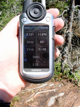
Trip mileage is accurate, but tracking distance is off by approximately 10%
Temperature is overstated by 5-10F.
Temperature will not adjust quickly enough when a weather front comes thru
The unit has a problem with picking up stray tracks that can be 1,000' off course, and then suddenly go back on track
Garmin states that the unit will last 16 hours. The most we could get out of the best set of batteries was 9 hours. This was after turning down the lighted display, and turning off all other features.
Garmin does not include recharable batteries. For $600 you would expect them to throw in some $10 rechargable batteries
When you turn on the unit, it always comes up with 37F, and will not track points until the temperature adjusts itself correctly. This can take 10-30 minutes before the unit will start working.
Frequency of tracking points by distance does not work well for hiking. Lowest tracking is every 50 feet. But, with the forest canopy, it usually tracks every 150-200'. This causes the mileage to be understanded. The only way to make it work correctly is to change the tracking to time (every 5 seconds). If if you rest, you end up with a large pile of worthless tracks.
The Stopped Time Clock and Moving Time Clock do not work correctly for hiking. A lot of hiking time ends up on the Stopped Time Clock. If you hike non-stop, the unit comes up with 40% of the time you were stopped. It is calibrated for automobiles instead of hiking.
Sometimes you will find a trail entered on the topo map. But, the trail is hand-drawn it, and is completely inaccurate.
The 400t will lock up often when temperatures fall below 50F. This results in a damaged file, and the hike must be redone. People who make maps carry 2-3 units to ensure that their work is not permanently damaged.
The MapSource Software is absolutely horrible! There is NO ability to manage and edit tracks. This makes the sofware very close to worthless.
The MapSource Software does not have topo maps included with the software. You have to export the tracks to another software program to get useable results.
The MapSource Software and the 400t will automatically add tracks while it is uploading to your PC, which completely clobbers the tracks and any map profile
The MapSource Software damages the file with you delete the stray tracks it collected while uploading. If you try to export it as a GPX file, it will blow-up and crash the MapSource Software. In some cases it will completely crash your computer. It also corrupts the GPX file, and makes it unusable.
The MapSource Software does not come up with accumalive mileage from the start of the hike. So, you have to keep the mileage post in a paper notebook as you hike. Even if it did work, the tracking mileage is not accurate and is overstated.
The MapSource Software is a bug ridden piece of junk. Garmin really needs to put it out of it's misery.
Tech Support took three phone calls before they would agree to fix the unit.
|
|