Poet's Ledge |
 |
| |
| |
|
OVERVIEW |
| | Type of Trail: | 100% DEC Trail & roads |
| | Distance: | 6.14 miles round trip from parking at bridge to Poets Ledge and back |
| | Time: | Average 4.5 hours round trip |
| | Elevation Gain: | 1,661 feet from parking lot to Trail Junction to Poet's Ledge |
| | Best Time to Hike: | Arrive at Poets Ledge between 12 and 2 (Fall season is the best) |
| | Difficulty: | Moderate |
| | Notes: | Access to DEC land is not accessible during hunting season |
| | |
| | | USGS Official Map: | Kaaterskill Topographical Map (free) |
| | |
| | | DEC Trail Map: | DEC Kaaterskill Wild Forest Map (free) |
| | |
| | | Digital Mapper: |
Topo
Terrain
Satellite |
| | |
| | | Access Methods: | Foot and snowshoe. |
|
|
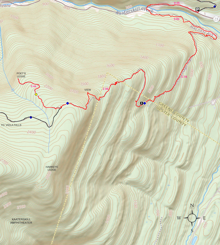
Maps |
 |
|
|
|
| | Directions to HARDING ROAD Parking Area |
| | Harding Road Parking Area WGS84 (DEC): 42.176236,-74.030495 - Elevation is about 680' feet |
| | Harding Road Parking Area Deg/Min/Sec: N42 10 34, W74 01 49 - Elevation is about 680' feet |
| | Harding Road Parking Area GPS: N 42 10.574 W 74 01.830 - Elevation is about 680' feet |
| | Harding Road Parking Area UTM: 18N 580071 4669799 - Elevation is about 680' feet |
| | Harding Road Parking Area (Google Maps)
|
| |
|
| | Take New York State Thruway to Exit 21 (Catskill). |
| | Take a left out of the NYS Thruway entrance road. |
| | Go approximately 1/4 mile |
| | Take a right onto Route 23 West |
| | Go approximately 6.6 miles on Route 23. |
| | Take a LEFT onto Rt 32 (McDonalds on corner). |
| | Go approximately 7.7 miles on Route 32. |
| | Take RIGHT onto Rt 23A. |
| | Go approximately 2.6 miles on Rt 23A . |
| | Take a Right into the DEC Harding Road Parking Area in Palenville |
| | Some people have parked at the Fernwood Resturant (with permission - they eat there once they are done with the hike). |
| | You cannot park at the trail head! |
| | Do NOT park by the red building next to the bridge. |
| | Do NOT park on Malden Ave or in someone's driveway on Malden Ave. |
| | Do NOT drive up the dirt entrance road to the trail head - this is PRIVATE property - AND there is NO place to park or turn around once you get to the trail head. |
|
|
NOTES ABOUT THIS HIKE |
| | The first 1.40 miles of this hike runs over public roads and private land. You will walk on public roads for 0.61 miles, and 0.79 miles on private land (dirt roads). The private lands provide the public with a "right-of-way". Most of the people in the area really don't want you to hike this trail, and present obstacles to make it as difficult as possible. You will also see numerous No Parking signs, No Trespassing signs, closed metal gates blocking the path, and guard rails to block you, overgrown paths, poison ivy, etc to discourage you. They go out of their way to make finding the trail head and accessing it as difficult as possible. But, if you follow our instructions, you have every legal right to hike this path. In spite of their actions, please respect the owners land, and do NOT leave the road, and be respectful to the owners.
30 years ago, Malden Ave was not blocked off at the Rt 23A end, and you could park on Malden Ave. When they closed sections of Malden Ave where people parked, this historic trail started to die. Now it is very rare that local people hike this trail. A very sad situation for such a great and historic hiking path.
Once in a great while, someone sees a rattlesnake on the hike from Malden Ave to Poet's Ledge. There is a small den on one of the ledges below Hawkeye Ledge. |
|
|
MILEAGE CHART |
| |
Mile Point |
Altitude |
Notes |
| | 0.00 | 1,872' | DEC Parking Lot. 42.176236,-74.030495 |
| | 0.00 | 680' | Parking - From Route 23A turn onto Malden Ave - Walk past double guard rails (watch out for poison ivy on left side of road). |
| | 0.62 | 680' | Walk up wide dirt driveway about 250' ( look for green Long Path trail marker on tree - hard to see from Malden Ave) - Turn right and walk up narrow dirt driveway past metal gate (If gate is closed, walk around gate). |
| | 1.01 | | Road branch - Go straight |
| | 1.27 | | Road branch - Go Right |
| | 1.33 | 1,255' | Road Branch - Go Right - leave dirt road and continue onto the foot path |
| | 1.40 | | Leave private land onto public land |
| | 2.13 | 1,955' | Level off for a while |
| | 2.31 | 2,067' | Giant steps |
| | 2.34 | 2,102' | Ledge #1 (views) |
| | 2.44 | 2,264' | Rock-in-the-Path |
| | 2.52 | 2,325' | Reach top of moderate ascent - Levels off after this for several miles. Total ascent of 1,661'. |
| | 2.57 | 2,317' | Start of Boreal Forest (Watch for black bears at this point) |
| | 2.63 | 2,341' | Trail Branch - go right to Poet's Ledge (0.44 miles) - Yellow trail markers |
| | 2.98 | 2,187' | Mossy Notch |
| | 3.07 | 2,145' | POET'S LEDGE - Outstanding View! - Enjoy. Be careful of the opening between the rocks on the ledge. It is a 30' fall. |
| | 6.14 | 680' | Return to the Harding Road Parking Lot |
|
|
|
 |
Park at the DEC Harding Road Parking Area in Palenville. GPS (WGS84): 42.176236,-74.030495 (type in this GPS coordinate into your iPhone Maps program in the search box.
There is another off-road parking area about 1/2 mile up Rt 23a. But, it almost always fills up before the DEC Harding Road Parking Area in Palenville. |
|
 |
 |
After parking at the DEC Harding Road Parking Area in Palenville, walk WEST on Rt 23a until you come to the bridge.
Walk over the bridge and take a LEFT onto Malden Ave (In front of the red building).
The mileage for this hike starts where you see the red building. It is the closest place to the trail head. |
Walk around the barrier. You will have to wade thru the brush at the beginning of this barrier. Then you can continue walking on the road until you reach the barrier on the other side of Malden Ave. Continue down Malden Ave. The distance to the dirt road that is the beginning of the trail is 0.62 miles.
NOTE: Malden Ave is a PUBLIC road from Rt 23a to 32a. In spite of a section of Malden Ave being closed to vehicle traffic, it is still a public road. You are legally allowed to walk around the barrier. This has been verified by Greene County Records office that holds the deeds. There is one particular land owner that wants the public to think that he owns Malden Ave. He does not own any part of Malden Ave! |
|
 |
 |
From the other side of Malden Ave, this is the entrance to the Long Path/trails into the Kaaterskill High Peak region.Walk up this driveway.
Absolutely do NOT park here, or drive up this road. This road is private property, and you only have the rights to walk up the road to access the trail head. The trail head onto public land is 1.40 miles from the bridge. I can assure you that if you park here, your car will be towed.
If you look very carefully from Malden Ave, you might see the green Long Path trail marker on the tree. You have to look very carefully. |
After walking 150 feet up this driveway, turn RIGHT onto a smaller driverway. You will see a DEC sign denoting that this is the way to the trail. 30 feet after turning right you will see a steel gate. You can walk around the gate and continue up the road.
There is another metal gate further up the road. Walk around that one too, if it is closed.
The picture on the right shows the sign denoting the direction to the trail. The first metal gate blocking the road is just past the sign denoting the trail. |
|
 |
 |
At mile marker 1.01 (from the intersection of Rt 23a & Malden Ave), you will come to a 3-way intersection. GO STRAIGHT.
You will see trail markers, so follow them if you get confused.
There is another road on the right of the picture (which you cannot see in the photo). |
At mile post 1.27, you will encounter the second trail branch. You want to GO RIGHT. Again follow the trail markers. |
|
 |
 |
At Mile post 1.33 (elevation 1,250') the road will branch again. This time the branch will move off the road on to a foot path. If you were to continue further, you will run into the property owners house. So, try not to disturb them.
At Mile post 1.40, you will leave private land and will enter public land. At this point you can leave the path if you so choose.
The path will continue on a steady moderate uphill ascent. |
At Mile post 2.31 (Elevation 2,067) you will encounter The Giant Steps. These rocks tend to be slippery. |
|
 |
 |
At Mile post 2.34 (elevation 2,102) you will encounter the first ledge with a view. From this ledge you can clearly see Indian Head Ledge, Palenville Overlook Ledge, and Boulder Rock. You will also be able to see down into Palenville and the Hudson Valley. |
At Mile post 2.44 (elevation 2,264) you will encounter "Rock-in-the-Path".
At Mile post 2.52 (elevation 2,325) you will come to the end of the long ascent. (At this point you have completed the 1,645' vertical ascent. At this point, the trail will continue on a level path all the way to Twilight Park.
At Mile post 2.57 (elevation 2,317) you will enter the beautiful conifer forest that has old growth trees. Some are 3+ feet in diameter. |
|
POET'S LEDGE (Optional) |
 |
 |
OPTIONAL SIDE TRIP: At Mile post 2.63 (elevation 2,341) you will encounter a Trail branch. If you go right it will lead to Poet's Ledge. The trail is marked with Yellow Trail Markers. The detour to Poet's Ledge is 0.44 miles one way or 0.88 miles round trip. Most consider Poet's Ledge the best part of the hike. If this is the end of your hike, your round trip mileage will be 6.14 miles. The trail will be a 196' drop in elevation from the trail junction down to Poet's Ledge. |
This is what the beginning of the trail to Poet's Ledge looks like |
|
 |
About 2/3 of the way down to Poet's Ledge, you will encounter two ledges. Neither of these ledges are Poet's Ledge. Continue on the path until the path absolutely ends. Then you will be at Poet's Ledge. |
|
|
This is the view of Poet's Ledge. While the photo is beautiful, it really does not do justice to the view you will get. On a clear crisp day, the vistas are awe inspiring.
Safety Note: There is a benign looking crack in the ledge. If you look carefully, there is a 30' drop into a cave.
The best time to arrive at Poet's Ledge is around noon time to 2 PM in the afternoon. Late in the afternoon is the worst time. The photo above was taken at 10 AM. It takes 2 hours and 15 minutes to get there.
The mileage from the Long Path to Poet's ledge is 0.44 miles, and the elevation at Poet's Ledge is 2,145'. There is a 197' drop in elevation.
After you return back to the original trail, take a RIGHT and continue down the path.
Optional side-trip (minor bushwhacking) - After you get back on the trail, you will cross a small little stream (Hillyer). Maps from 50-60 years ago show a trail branch by the stream that will lead up to Hawkeye Ledge. The trail to Hawkeye is now overgrown and not visible. If you follow the stream uphill, it will lead you to Hawkeye Ledge. Hawkeye Ledge is located on the corner of the eastern escarpment and Kaaterskill Amphitheater. There is a large flat ledge with some views into the Amphitheater. Most of the view is now overgrown. When the leaves are not on the tree, the view is nice. Some people do camp on the ledge. Great place to camp for the night. |
|
|
S E C T I O N S
|
W E A T H E R
|
O T H E R
|