Historians know that Indians inhabited the Hudson Valley 10,000 years ago. At some point, thousands of years ago, Indians from other areas moved into the Kaaterskill Mountain Range and Valleys. When White people started exploring and settling in the valleys, they often noted numerous trails thru the Kaaterskill Mountain Range. Most didnt venture in the Kaaterskill Mountain Range. Those who did often did not return. They were either killed by Mountain Lions, Indians, or fell off ledges.
We know that the Indians had at least two camps near Kaaterskill High Peak back as far as the French Indian War (1754-1763). We also have historic referenced to Brant Fort being used during the French Indian War. Due to the extensive number of trails thru the Kaaterskill Mountain Range, Indians had to lived there for thousand of years. We also know that the British Tories used Brant Fort during the Revolutionary war.
Rip Van Winkle lived on a farm just outside of Palenville ( just north of Palenville). He spent a lot of time hiking the Kaaterskill Mountain Range and the North/South Lake Region.
On July 26, 1793, Peter DeLaBigarre (French) ascended Kaaterskill High Peak. He was the first White person recorded to ascend the mountain. He then named the peak, Liberty Cap (later changed to Kaaterskill High Peak - recently changed to High Peak, but that name is being ignored, and everyone is calling it Kaaterskill High Peak). Peters trip to Kaaterskill High Peak also included Overlook Mountain and North/South Lake region. Peter also had a partner who had a barameter, and came up with an elevation measurement of 3,549 feet (106 short of the true elevation). There is also some confusion that they actually measured Round Top Mountain instead of Kaaterskill High Peak. For many years, this was considered this to be the first ascent of Kaaterskill High Peak. Today, we now that this claim is laughable. Indians had at least two camps at 2,640 and 2,900 feet. Peter also claimed that Kaaterskill High Peak was the highest mountain in the Catskill Mountains. Today we actually know that it ranks 23rd. This account was published in an article in the Journal of Transactions in 1794.
Peter DeLaBigarres work lead to famous painting done by Thomas Cole from the Kaaterskill Mountain Ranges. And Thomas Coles painting lead to the construction of hotels around North/South Lake region, and a large influx of wealthy people to the region to visit. The hotels then lead to the construction of Twilight Park, Elka Park, and Onteora Park (wealthy families building homes in communities). These three communities compraise around 10,000 acres of land. This lead to the construction of four ski resorts in the surrounding area. Tourism is still the major industry in the Catskill Mountains today. All of this can be attributed to and traced back to Kaaterskill High Peak.
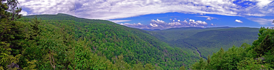
Thomas Cole and his artist friends made many famous paintings of Kaaterskill High Peak, Round Top Mountain, Haines Falls, Kaaterskill Falls, Fawns Leap, and many other areas in the Kaaterskill Clove and surrounding Mountain ranges.
In the early 1800s trappers hunted the range clean of many animals. The Kaaterskill Mountain Range was absolutely teaming with Mountain Lions, Panthers, Bobcats, Gray Wolves, Black Bears, Deer, etc. Some of these species were hunted to extinction.
In the early 1800s loggers showed up and stripped a majority of the mountain of the huge Hemlock and Pine trees that covered the mountain. Due to the steep area of the North face, some areas have never been cut, due to the dangerous steep slopes.
In the 1870s Arnold Henry Guyot (Princeton Professor), surveyed numerous mountains in the Catskill Mountains, and determined that Kaaterskill High Peak is NOT the highest peak in the Catskill Mountains. This fact angered many of the local hotel owners, because they used this fact to attract customers. It should be noted that the elevation climb from Palenville to the top of Kaaterskill High peak is one of the largest.
During the early 1800s many trappers hunted and trapped the Kaaterskill Mountain Range clean of animals. Later in the1800s loggers stripped the Kaaterskill Mountain Range of trees. Animal pelts were snapped up by people in New York City. Lumber from the Hemlock trees were used to frame many of the homes in the surrounding area. Hemlock trees were also used to frame the three major hotels around North and South Lake region (Laural House, Kaaterskill Hotel, and Catskill Mountain House).
In 1921 the Kaaterskill Mountain Range was purchased by New York State and became designated as a NYS forest perserve. For many decades the North Access to Kaaterskill High Peak was a popular hiking trail. This trail is one of the oldest hiking trails in American loaded with history.
When they closed a the road (Malden Ave) at the North Access point, and put up no parking signs, this entire mountain ranged started to die as a viable hiking range. This lead to the NYS DEC to neglecting the trails. Presently there are trees that have been across the trail for over a decade. Some of the trails that have existed for centuries are not being maintain (Hawkeye Ledge, Johnson's Point, Round Top Mountain). The trail to Round Top Mountain is no longer being maintained. When a large parcel of property became available on Gillespie Road (access to Round Top Mountain), NYS DEC failed to purchase the land. Instead, New York City DEP purchased the land and initially blocked access to this region. Shortly thereafter, NYC DEP opened up the land to hiking. This is now leading to hiking in regions of the mountain range that had not been hiked in years. The new parking lot in Platte Clove (Devil's Kitchen) is generating a lot of new activity. Until the NYS DEC acquires the property on the closed section of Malden Ave the North Access to Kaaterskill High Peak, this entire mountain range will suffer. These few property owners are now posting no trespassing and no parking signs on DEC and State property to block as many hikers as possible from accessing the North Access trail head.Some property owners are taking down trail markers to make it very difficult to find the trail access.