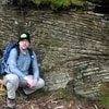
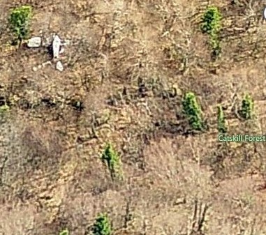
To find this plane crash, I had help from above ... aerial images that is. I had heard that there was a plane crash near Acra point (N2617A). Had no real info on it, except the NTSB accident report. So, I started studying the aerial images (using Bing maps) on the off chance that I might spot something. I did see somthing suspicious along the eastern edge of the escarpment between Acra point and the notch with Blackhead mountain at around 2500 feet elevation. It looked like it could be a plane body and one wing ... or it might just be some big white rocks... no way to really tell. I could also see an old road that headed down from the col. So, I programmed my GPS and headed out. Parked at the end of CR 56 and headed up the Batavia Kill trail. Went past the lean-to, which was unoccupied, and then soon reached the intersection with the Escarpment trail. Continued straight on a path and then the old road which I followed down the other side for about 3/4 mile. I then left the road, and it was a short 5 minute climb up to the site. It turns out, that it wasn't the plane I was looking for - but a glider plane. There was a number on the underside of one wing - NC1157? (as far as I could tell) I took pictures and then continued climbing up the hill back to the Escarpment trail. Followed the trail over Acra point and then back down to the car. I searched the Internet, but couldn't find anything on this glider. Had a beautiful day though for this short trek in the woods.
Round-trip Distance: 5.5 mi
Elevation Change: 1600 ft
Location of glider site: 42°17'07.4"N, 74°05'40.2"W
some pictures
https://picasaweb.google.com/1101796538 ... directlink
If you want to just look at post, you do NOT need an account.
But, if you want to post comments you need to open an account. Please: Click Here to apply for an account.
But, if you want to post comments you need to open an account. Please: Click Here to apply for an account.
Acra point glider wreck
-
mike

- Posts: 1444
- Joined: Sun Aug 09, 2009 9:20 pm
- Location: Ravena, NY
Re: Acra point glider wreck
I never knew about this plane wreck. There is one off Burnt Knob on the Eastern Escarpment. I have seen it shining from Rt 23.
There was a glider crash just south of Windham High peak back in 2007? But, they carried it off the mountain in pieces. the pilots (commercial pilots) paid some locals to haul if off.
I presume that the old logging road you referred starts at the intersection of the Escarpment and the Batavia Trail?
-
mike
- Posts: 1444
- Joined: Sun Aug 09, 2009 9:20 pm
- Location: Ravena, NY
Re: Acra point glider wreck
I went to Bing to try and find the map you posted, but I only got the summer maps with the leaves on the trees.
-
Jon
- Posts: 324
- Joined: Tue Dec 20, 2011 9:43 pm
- Location: Bangor, PA
Re: Acra point glider wreck
Nice find! I'll have to check it out next time i'm in that location.
-
dave

- Posts: 712
- Joined: Mon Aug 10, 2009 3:14 pm
- Location: Acra New York
Re: Acra point glider wreck
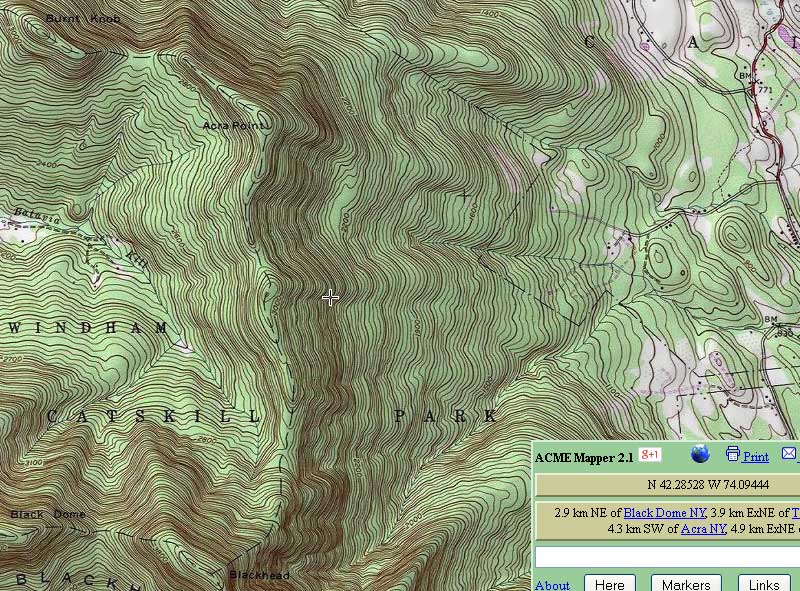
Here is a map of the plane crash site:
-
Rivet
- Posts: 18
- Joined: Mon Aug 13, 2012 6:39 pm
Re: Acra point glider wreck
You need to select the birds eye view option. You may also need to rotate the view. These views are not available in all areas and in all four directions ... Usually just along flight paths. There is good coverage over the northern and eastern escarpment. You can easily pick out the upper stoppel point plane wreck.mike wrote:I went to Bing to try and find the map you posted, but I only got the summer maps with the leaves on the trees.
-
Rivet
- Posts: 18
- Joined: Mon Aug 13, 2012 6:39 pm
Re: Acra point glider wreck
Yes, it is the old wagon road that leads down the other side. It seems to end somewhere near bailey road. Looks to get some use as there is a well defined foot path, but there are saplings starting to grow in. There are other logging roads visible in that valley (trout brook) from the imagery.mike wrote:I never knew about this plane wreck. There is one off Burnt Knob on the Eastern Escarpment. I have seen it shining from Rt 23.
There was a glider crash just south of Windham High peak back in 2007? But, they carried it off the mountain in pieces. the pilots (commercial pilots) paid some locals to haul if off.
I presume that the old logging road you referred starts at the intersection of the Escarpment and the Batavia Trail?
-
Nasrettin Hoca
- Posts: 33
- Joined: Thu Dec 02, 2010 10:50 am
Re: Acra point glider wreck
wow, this is outstanding!
I will have to try this. I started a thread two years ago about a wreck I'd heard about on Slide.
viewtopic.php?f=18&t=613
eta: I tried the Stoppel Point wreck as an exercise.
I will have to try this. I started a thread two years ago about a wreck I'd heard about on Slide.
viewtopic.php?f=18&t=613
eta: I tried the Stoppel Point wreck as an exercise.