2/15/13 South mountain (Ashokan)
Posted: Sat Feb 16, 2013 1:46 pm
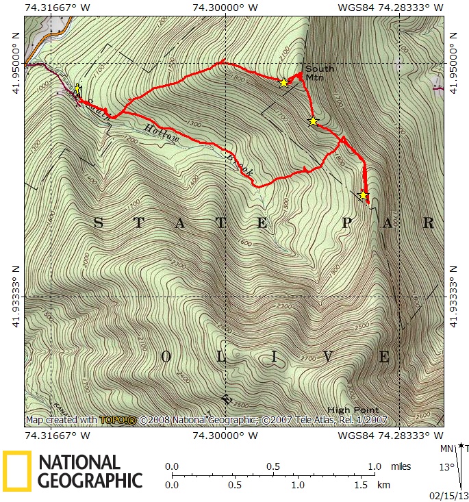
South mountain is the small peak next to Ashokan High Point. It easy to pick out from Route 28 as it has a small cell tower now (which is a bit north of the true summit). I decided to climb it today with my beagle Howie. Parked just before the end of South Hollow road where there are a couple of places to pull off. I followed the state land boundary (yellow daubs) to skirt around the last house at the very end of the road. This necessitated crossing the south hollow brook which wasn't too hard. Continued following the boundary line around the last property and then hooked back up with south hollow road (old dirt road at this point). Passed the typical old stone walls and foundations that you usually see at lower elevations. There was a clearing which was a designated camp site. The road eventually petered out after about a mile (around 1400 ft elevation). I continued on up to low point on the ridge. I could have swore that I saw 2-3 coyotes running up the hill. Either coyotes or wolves or wild dogs. They were barking. There were dog-like prints all over the woods. No human prints anywhere. There is wedge of non-state land on the ridge, but it is otherwise un-posted. Turned south and continued toward a series of cliffs with some sweet views. Had about a 180 degree view to the north, west and south. Stopped for lunch and picture taking. It was a bit breezy, but still warm with the strong afternoon sun. Backtracked along the ridge. Stumbled upon a very clear path which I believe is the old trail up AHP. Followed it down to the col. It veered right and down the other side of the ridge at that point. I abandoned it and just continued on up to the summit of South mountain. There were some lower ledges which had views. Reached the summit and checked out the upper ledges with had more views. Headed back down the western ridge. There was a bunch of mountain laurel to slow my progress. Eventually made it back to the car. Only a couple inches of mushy snow with many bare patches. This was a surprisingly nice little bushwack hike. A future possible hike might include a loop over AHP using south hollow brook trail, old AHP trail and Kanape brook trail.
Summit Elevation: South Mountain 2191
Round-trip Distance: 4.5 mi
Elevation Change: 1300 ft
Pictures
https://picasaweb.google.com/1101796538 ... directlink
I am including my route. My GPS was off most of the trip so it is approximate (i.e. I drew it on the map). I marked the view points on the map.
Summit Elevation: South Mountain 2191
Round-trip Distance: 4.5 mi
Elevation Change: 1300 ft
Pictures
https://picasaweb.google.com/1101796538 ... directlink
I am including my route. My GPS was off most of the trip so it is approximate (i.e. I drew it on the map). I marked the view points on the map.