Westkill/SW Hunter 1/3/13
Once again Brian and I met up on 1/3/13, at the Park and Ride near the Kingston/Rhinecliff Bridge to head off on another peak bagging extravaganza. It was nearly zero degrees, a mere 5 degrees was displayed on my car's dashboard. Driving from the town of Rhinebeck to the Park and Ride, my field of vision was limited to a 2'x2' hole, through the frosted windshield. Luckily at this hour not too many people are on the road.
We took Rt.28 - Rt. 42 and finally made a right hand turn onto Spruceton Rd. I can remember what this place looked like shortly after Irene graced us with her presence. There is still evidence to be found in just about every roadside stream/river and then of course the notorious slide on Rt. 42. Speaking of which, Brian mentioned that some folks expressed interest in climbing said slide, well this is the time of year to do it! Might be a fun physical challenge, but aesthetically speaking it's not all that cool. Yet again the tangle of roots, unconsolidated dirt/rock, trunks, and the like may appeal to those with finer senses than myself.
There was steam issuing forth through the partially frozen West Kill along Spruceton Rd on the way to the trail head. Another reminder of how dang cold it is! There weren't any cars parked at the two other trail heads we passed on the way to the one at the end of the road. Wonder why? The time of our arrival was 8:30am (no band, red carpet, or hot beverages for our reception).
After the usual monkeying around to get our packs ready, boots on, and then snow shoes strapped, we began the march. There wasn't a register at the beginning of the trail (I later discovered that it was actually next to where we parked, at the kiosk, on the other side of a large snow bank). The walk to Diamond Notch Falls probably took fifteen minutes, or so. On the way, Brian noticed a frozen Wood Frog sprawled out in the trail, that I managed to miss, but later discovered on the way out. Kind of unusual for this time of year. I wonder what dug this critter out of his winter quarters? Correct me if I'm wrong, but these Wood Frogs have some sort of antifreeze that enables them to live very far North, like way the heck up there…Unlike the rest of their brethren.
The crossing of the upper West Kill was super easy, but we equipped ourselves with micro spikes and hills hounds nonetheless. There is a large slab that jets out almost to the other side that had some nice ice on it, so we just walked to the edge of this and then hopped to the other side. No wet socks, or the like. The trail on the way to this crossing and after, during the approach of West Kill has been butchered in every way. We did our best to groom it on our way back out with snowshoes. Unfortunately this didn't do much, but we tried to play the role of decent stewards, or better yet custodians, after all we were cleaning up after someone else's mess!
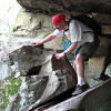
We stopped at The Cave for a bit and had some water, the sun was shining into the cave, which created a tempting scene…At 10:20am we got to Buck Ridge Lookout, at least I did. Shortly thereafter Brian arrived. One of the best places in the Catskills without a doubt and given the baby blue skies, sun, passing clouds, and snow covered ridge lines/peaks it made a pretty nice scene.
The summit of West Kill was reached at 10:50am. There is no longer a DEC sign indicating the summit, but the partially covered summit cairn was visible.
At 12:00 we reached the Diamond Notch Falls crossing and had some water at the nearby junction to Hunter. On the way down we had discussed a possible deviation from our original course in order to bag Hunter proper as well. However once we began to encounter heavy drifting on the way up to Geiger Point we soon scratched that idea.
Below Geiger Point it looked as though someone on shoes had made an abrupt turn around and decided to call it a day. There was deep powder to be plowed through from here to Geiger Point and just about to the Junction for SW Hunter.
At Geiger Point 1:10pm there was still unbroken snow all around. Brian hopped over the small crack separating the Point from the mountain, while I watched and had something to eat/drink.
After Geiger Point the day started to catch up with me. I wanted to get to SW Hunter as quickly as possible sign in and then get back to the car. I made the first mistake by following a trail 200ft below the true junction, marked by the dead tree with a red DEC disc. Not to worry we were soon back on the rail bed trucking at a good clip towards the summit. Then I really erred. There is a well trodden trail breaking off to the left well before the actual turn to the summit. Once again I decided that this would pan out favorably. Brian was behind me and I failed to pause at the split to wait for him, so that we could discuss our options. About two tenths of a mile in I started to curse myself for taking this trail. I kept walking faster in the hopes of finally breaking out of the dense balsams to the canister clearing. Not happening. Soon I decided to stop and wait for Brian, which I should've done way before this point. He was just as dismayed as I was. This thing was meandering all over place and taking us into places that not even my dog would venture into.
Luckily the trail of tears did end soon there after, in other words we reached the canister at 2:10pm. However the hike isn't over yet. Coming from a place of much frustration, we tried to hit the rail bed without following any other prints. Somehow we managed to miss the bed and ended up only 50ft, or so below it. However we were unsure whether we had gone below it, or had not yet reached it. Thankfully we were together this time and discussed our options. We agreed on the general direction we should head in (no brainer), but whether to head up, or down was a little more difficult. I insisted up, while he insisted down. I'm glad we held our ground, because after going down, then up, down, then up, we finally went up once more to finally break out onto the rail bed! Needless to say my nerves started to cool down, after amateur hour ended. This time of year always puts me on edge, especially when the sun has gone past it's zenith for the day! Good thing Brian didn't have his camera out at this point, you would see a look of dire consternation on my face.
So for anyone else walking up to SW Hunter who plans on having the experience you had in Spring, Summer, or Fall be prepared for a different perspective. Be patient and turn where there is a dead tree with a red DEC disc and stay on the bed. Do not take the first left hand turn onto a well trodden, tempting, distinct path through the snow. Make the left that isn't heavily trodden that is past the aforementioned turn. Classic example of why one should not follow the herd!
The walk back was quick and didn't offer much resistance. The areas that were deep on the way in around Geiger Point were nice and compact, but not too compact like over on Westkill (bare-booters).
Got back to the car at 4:00pm and then stopped at Stewarts on Rt.28 on the way home.
Close to 11miles round trip and 3500' of elevation gain.
Here are some pics: http://sdrv.ms/UOZ28o (compliments of Pathgrinder)
-Sam
If you want to just look at post, you do NOT need an account.
But, if you want to post comments you need to open an account. Please: Click Here to apply for an account.
But, if you want to post comments you need to open an account. Please: Click Here to apply for an account.
Westkill/SW Hunter 1/3/13
-
Sam

- Posts: 71
- Joined: Wed Sep 07, 2011 9:17 pm
- Location: Rhinebeck NY
Westkill/SW Hunter 1/3/13
Last edited by Sam on Wed Jan 09, 2013 11:22 am, edited 1 time in total.
-
SNEAKers
- Posts: 158
- Joined: Wed Aug 03, 2011 3:30 pm
Re: Westkill/SW Hunter 1/3/13
Great trip report! Glad you guys didn't get lost out in the cold. Love the pics, especially the wood frog (who will be fine as long as it doesn't get gobbled up!) and the Buck Ridge Lookout panorama.
I will hopefully be doing this hike this summer!
I will hopefully be doing this hike this summer!
-
mike

- Posts: 1444
- Joined: Sun Aug 09, 2009 9:20 pm
- Location: Ravena, NY
Re: Westkill/SW Hunter 1/3/13
I should note that the DEC is now changing the registration location. They seem to be moving away from the metal registration boxes and moving towards a wooden registration box at the kiosk.There wasn't a register at the beginning of the trail (I later discovered that it was actually next to where we parked, at the kiosk, on the other side of a large snow bank)
Interesting note about the Wood Frog. We saw some Snow Flies this past weekend. They look like spiders. Spiders have 8 legs and these had 6 legs. Odd to see.
Nice trip report.
-
Sam
- Posts: 71
- Joined: Wed Sep 07, 2011 9:17 pm
- Location: Rhinebeck NY
Re: Westkill/SW Hunter 1/3/13
Two days ago I noticed that they've also got one of the new wooden registers at the end of Big Hollow Road. Maybe they're trying to catch the Catskills up with the Adirondacks? I've only seen wooden registers up there...
-
kennykb
- Posts: 241
- Joined: Tue Apr 24, 2012 11:19 pm
- Location: Niskayuna, NY
- Contact:
Re: Westkill/SW Hunter 1/3/13
Last time I was in on the rail grade someone had built two cairns where the herd path leaves the grade. Has someone broken the cairns again? (That's probably good, we don't want the herd path turning into a blazed trail, but it's really a lost cause.)
The path was blocked by one big blowdown, and I guessed wrong about which way to go around it and wound up traipsing up through spruce and witch-hobble. Then I spent about 20 minutes finding the canister. I eventually cheated and homed in on it with my GPS. I'd swear that the thing was about 100 yards DOWNHILL from where I was standing, but it's hard to tell on that flat summit.
Anyway, sounds like a great day!
I'm not lost. I know exactly where I am. I'm right here.
-
Sam
- Posts: 71
- Joined: Wed Sep 07, 2011 9:17 pm
- Location: Rhinebeck NY
Re: Westkill/SW Hunter 1/3/13
The snow wasn't super deep, so I assume the cairns have been demolished. Not that it really matters. There will always be a trail on the rail bed, so long as there is a club that requires members to climb the mountain. Or a curiosity to see where the "unmarked trail" leads. Very easy bushwhack from this approach. However some folks walk up the ravine from Diamond Notch Falls. We considered going down this way, while we were feeling turned around, but soon hopped back on the rail bed.
Great stands of Balsam up there, but not much else.
Great stands of Balsam up there, but not much else.
-
mike
- Posts: 1444
- Joined: Sun Aug 09, 2009 9:20 pm
- Location: Ravena, NY
Re: Westkill/SW Hunter 1/3/13
Cairns have an official position on Federal land. In National Parks, they keep the canisters inside the rock cairns. But, in New York some hikers don't like them. In New York they have removed most of the canisters. But, there are still some in the Catskills. I personally would prefer to see the canisters placed in cairns. Just my opinion.
The rock cairns have been on the rail bed to Leavitt for quite a few years.
Almost all the 3500 canisters are NOT on the true summits. Some are way off from the summit. Friday is a good example.
I am not sure how well the wooden registration boxes will hold up.
The rock cairns have been on the rail bed to Leavitt for quite a few years.
Almost all the 3500 canisters are NOT on the true summits. Some are way off from the summit. Friday is a good example.
I am not sure how well the wooden registration boxes will hold up.
-
Sam
- Posts: 71
- Joined: Wed Sep 07, 2011 9:17 pm
- Location: Rhinebeck NY
Re: Westkill/SW Hunter 1/3/13
Yes, some people dislike Cairns/Canisters. As far as I know all the canisters are still intact in the Catskills and are well respected by the hiking community that I've had the pleasure to come into contact with. Up in the Adirondacks they're gone. Cairns are a great way to channels the flows of hikers through environmentally sensitive areas such as the Alpine areas of the North East. Very good indeed! Haven't really had much experience with canisters/log books placed in carins. I know out in the sierra on some of the peaks that require a lengthy approach/technical rock/ice climb have log books in metal ammunition boxes with rocks piled around the box.