If you want to just look at post, you do NOT need an account.
But, if you want to post comments you need to open an account. Please: Click Here to apply for an account.
But, if you want to post comments you need to open an account. Please: Click Here to apply for an account.
Maps
-
erik7181
- Posts: 37
- Joined: Tue Aug 23, 2011 8:02 pm
Maps
Are there any other topo maps worth buying for hikeing, i have last years trail confrence maps, should i buy the new ones? Im going to round top on the 24th to check out the tory fort area, Does anyone have an estimate on how long it would take from the trail head to the plane crash as i dont want to get stuck in the dark.
-
mike

- Posts: 1444
- Joined: Sun Aug 09, 2009 9:20 pm
- Location: Ravena, NY
Re: Maps
Nat Geo Maps now has a map for the Catskills #755. Not as good a VO Maps, but still a good alternative.
Check out this page for information on distance and time:http://www.catskillmountaineer.com/hiki ... skill.html
Also depends upon which Plane Crash you are talking about.
I think it will be available for sale here on this web site shortly.
Check out this page for information on distance and time:http://www.catskillmountaineer.com/hiki ... skill.html
Also depends upon which Plane Crash you are talking about.
I think it will be available for sale here on this web site shortly.
-
erik7181
- Posts: 37
- Joined: Tue Aug 23, 2011 8:02 pm
Re: Maps
Hi,
The plane crash on this page: http://www.catskillmountaineer.com/KM-KHP-RT.html And we where actully going to hike the snow mobil trail i think its the north side to the crash sight as that is the only way we've been before, but we have never made it to the crash.
The plane crash on this page: http://www.catskillmountaineer.com/KM-KHP-RT.html And we where actully going to hike the snow mobil trail i think its the north side to the crash sight as that is the only way we've been before, but we have never made it to the crash.
-
mike
- Posts: 1444
- Joined: Sun Aug 09, 2009 9:20 pm
- Location: Ravena, NY
Re: Maps
Okay. You are looking for the upper plane crash. Right now the trail up the North Access is very icy. Someone fell last week and broke their leg. They were wearing cramp-ons. But, it is getting warmer, so it might be okay this weekend. But, I sort of doubt it.
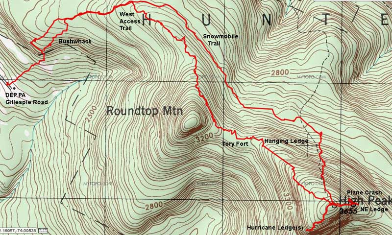
Once you get to the top of KHP, take the Northeast trail. Just before you get to the end. Maybe 100' from the end, there will be a flat section (maybe 30-50' long). It is just after a small steep section. Take a 90 degree right. The plane crash is about 100' in the woods. There are plane parts everywhere. It slammed into the ledge (steep section).
NOTE: If it is icy, do NOT go down to the NE ledge. It is dangerous enough when you are on dirt. If it is icy, you are taking very big risk.
Here is a map:
Catskill Mountaineer is redoing it's map section. It is not available to the public yet. I can give you a link for the new USGS Topo maps if you want it. The download is about 18mb.
Some of us have been loosely thinking about a hike up the West Access to KHP this Spring. You are welcome to join us. But, at this time we have not even thought about a date.
-
mike
- Posts: 1444
- Joined: Sun Aug 09, 2009 9:20 pm
- Location: Ravena, NY
Re: Maps
Here is the new proposed USGS Map page on Catskill Mountaineer: Kaaterskill USGS Maps
Go to the bottom to access all the USGS Topo maps for the Kaaterskill Quad Topo maps. I think the 2nd two are 1:24,000 (7.5min) maps. The historic map is 1:62500.
None of them show the DEC trails.
Go to the bottom to access all the USGS Topo maps for the Kaaterskill Quad Topo maps. I think the 2nd two are 1:24,000 (7.5min) maps. The historic map is 1:62500.
None of them show the DEC trails.
-
Jon
- Posts: 324
- Joined: Tue Dec 20, 2011 9:43 pm
- Location: Bangor, PA
Re: Maps
Well my geology teacher loves quads and makes us use then all the time. However they lack a few things for hiking catskills.
I feel that 1:24000 is too large a scale(or is it small). I much prefer a 1:63,360 (1 inch = 1 mile) for hiking purposes. You have more detail with the quads, but they are too impractical to cover an area.
also I think if you print them it throws the scale off
I feel that 1:24000 is too large a scale(or is it small). I much prefer a 1:63,360 (1 inch = 1 mile) for hiking purposes. You have more detail with the quads, but they are too impractical to cover an area.
also I think if you print them it throws the scale off
-
erik7181
- Posts: 37
- Joined: Tue Aug 23, 2011 8:02 pm
Re: Maps
Mike,
I know your the expert when it comes to round top, Could you direct me on the location of tory fort? do you have a gps location also? When the weather gets warmer up there are there alot of bears? When I was up there me and my wife made it as far as the tory swamp area, It was right after the hurricane so the trail was really saterated and we turned around because it started to get dark. When i hike areas like that i use a GPS with the trail confrence maps. We are also going to do the escrapment trail next weekend, iv been to the katterskill hotel sight but I haven't been to the mountain house sight sense I was a kid.
I know your the expert when it comes to round top, Could you direct me on the location of tory fort? do you have a gps location also? When the weather gets warmer up there are there alot of bears? When I was up there me and my wife made it as far as the tory swamp area, It was right after the hurricane so the trail was really saterated and we turned around because it started to get dark. When i hike areas like that i use a GPS with the trail confrence maps. We are also going to do the escrapment trail next weekend, iv been to the katterskill hotel sight but I haven't been to the mountain house sight sense I was a kid.
-
mike
- Posts: 1444
- Joined: Sun Aug 09, 2009 9:20 pm
- Location: Ravena, NY