Saturday October 30, 2010 was forecast to be partly/mostly cloudy with high temperatures in the 40's. Perfect fall weather for a hike! I had been wanting to see Brant Fort for some time and here was the perfect opportunity.
I'd like to share a little secret for those hikers interested in photography. Believe it or not, cloudy days are preferable to sunny days for shooting artifacts and sites located in the woods. The reason is that cloudy days present even lighting without the harsh contrast between light and shadow that you get on sunny days.
I parked at the Platte Clove parking area around 8:00 am. The temperature was around 23 degrees, which was decidedly chilly. Fortunately, there was no wind. I headed up the Long Path to the junction with the unmarked trail to the Mohawk Indian Camp. There was a light coating of snow on ground. The unmarked trail ends at the Mohawk Camp. From there, you must ascend a berm (perhaps 15-20 feet high) and then bushwhack west a few hundred feet where you will intercept the Snowmobile Trail. I have noticed that due to continual bushwhacking by many hikers, a vague herd path is beginning to form from the camp to the Snowmobile Trail. From the top of the berm, I took a shot of the Mohawk Camp. Thanks to the light coating of snow, the circular shape of the camp site is clearly visible.
Once on the snowmobile trail, I continued west to the junction with the south access trail to KHP. From there, I stayed on the snowmobile for another 45 minutes or so until I reached the junction with the trail that descends to Brant Fort. Please note that if you are hiking from the opposite direction on the snowmobile trail (i.e., from Gillespie Road), the junction is VERY easy to miss.
Assuming you are coming from KHP and the Mohawk Camp (i.e., the direction I came), the snowmobile trail branches off to the right and the trail to Brant Fort (which is unmarked!) turns to the left (south) and descends a ledge. After a few hundred feet, the trail to Brant Fort will jog sharply to the left (east) and then to the right (west). If the leaves are down, you will have a spectacular view of KHP looming ahead of you.
After a short distance, the trail will curve again to the left so that you are facing south. At this point, you will be at the base of the ledge. It is here that you must leave the trail and begin your bushwhack to Brant Fort.
At the point where you begin your bushwhack, if you face west, you will see a hanging ledge. This is excellent "marker" to alert you to look for the trail when you return from Brant Fort. I would caution anyone who wants to explore the hanging ledge. There appears to be a fairly deep cave which would provide an ideal "home" for a bear. Please approach with caution!
Standing in the exact same spot, if you turn 180 degrees and face east, you will see a slight clearing that marks the beginning of your bushwhack.
The bushwhack from the trail to Brant Fort is less than a half a mile and will take approximately 10 minutes. It is actually very easy. Simply follow the base of the ledge and you will have no problems finding the fort or getting lost. When you reach the site, you will "know" you are there because of the fairly large clearing, and also because the terrain drops off about 75 feet to a swampy area. As you can see in the photo below, aside from the fallen tree in the left foreground, the shot I took is virtually identical to the shot elsewhere on this website describing the hike to Brant Fort.
I would also like to express my thanks and appreciation to the website persons who took the time to post detailed directions on how to find the Brant Fort. You did an excellent job and the directions were "spot on" perfect!
This view shows the swamp adjacent to Brant Fort.
Curiously, there is a clearing perhaps 200-300 feet west of the "official" Brant Fort site that actually looks like a better candidate. I've included a few shots of the "suspected" site below. I actually like the suspected site better for a few reasons:
1. There is a much larger open, cleared, and level area to support a structure.
2. There is a much better view of Platte Clove (documentation I've read about Brant Fort mentions that the fort offered a superb view of Platte Clove)
3. I found what I believe are the remains of primitive stone and earth foundations arranged at 90 degree angles.
Mike C and I are hoping to return to Brant Fort in the early spring (April) and do further exploration of the area. At the same time, I would like to locate the remains of a primitive logging railroad that followed the stream south of the swamp adjacent to Brant Fort. Mike Kudish wrote a superb book titled "The Catskill Forest: A History" and mentions the logging railroad in his book. We are hoping that Mike K will be able to accompany us. Anyone with a serious interest in the history, climate, flora, and fauna of the Catskills should add this book to their library.
Here is a shot of the primitive stone and earth foundations at the "suspected" site.
After spending some time exploring the area, I retraced my steps and headed back to my car. I reached the junction with the South Access Trail around 3:00 pm and seriously considered hiking up to KHP and Hurricane Ledge. Unfortunately, the short days of late fall left me with less than 3 hours of daylight and I decided that such an excursion would really be "pushing the envelope". Oh well, there's always next time!
If you want to just look at post, you do NOT need an account.
But, if you want to post comments you need to open an account. Please: Click Here to apply for an account.
But, if you want to post comments you need to open an account. Please: Click Here to apply for an account.
Brant Fort on Saturday October 30, 2010
-
rkugel
- Posts: 143
- Joined: Wed Nov 25, 2009 8:54 am
Brant Fort on Saturday October 30, 2010
You do not have the required permissions to view the files attached to this post.
-
mike

- Posts: 1444
- Joined: Sun Aug 09, 2009 9:20 pm
- Location: Ravena, NY
Re: Brant Fort on Saturday October 30, 2010
Great report Rich. There are a number of places west of the site that appeared to have activity from the past. We will have to check out that foundation. Further west there appears to be a place where there might have been a Mohawk Indian Long House site.
Just after the snow melts and before the leaves come out is the best time. I would like to find the rail road tracks too.
Just after the snow melts and before the leaves come out is the best time. I would like to find the rail road tracks too.
-
mtnclimber
- Posts: 496
- Joined: Sat Oct 10, 2009 10:46 pm
Re: Brant Fort on Saturday October 30, 2010
I had been down there, but couldn't determine what was what. Sounds like you two guys might be able to work this thing out. I look forward to reading about it.
-
rkugel
- Posts: 143
- Joined: Wed Nov 25, 2009 8:54 am
Re: Brant Fort on Saturday October 30, 2010
Mike, what is a "Long House"? I've heard that term several times, but I really do not know what it refers to.
Obviously, there was a lot of history and activity in this area long ago. I would like to learn more. I am definitely looking forward to our hike in April. It would be great if Mike Kudish could join us. He would be especially helpful in locating that old logging railroad. According to Mike K., it is still possible to find sections of primitive rail scattered about in the woods. In this case, the "'rail" was technically called "strap rail", since it consisted of a length of wood with a flat strap of iron bolted on top to support the railroad cars. In the case of this railway, horses or mules were used for power. There were no locomotives.
Obviously, there was a lot of history and activity in this area long ago. I would like to learn more. I am definitely looking forward to our hike in April. It would be great if Mike Kudish could join us. He would be especially helpful in locating that old logging railroad. According to Mike K., it is still possible to find sections of primitive rail scattered about in the woods. In this case, the "'rail" was technically called "strap rail", since it consisted of a length of wood with a flat strap of iron bolted on top to support the railroad cars. In the case of this railway, horses or mules were used for power. There were no locomotives.
-
mike
- Posts: 1444
- Joined: Sun Aug 09, 2009 9:20 pm
- Location: Ravena, NY
Re: Brant Fort on Saturday October 30, 2010
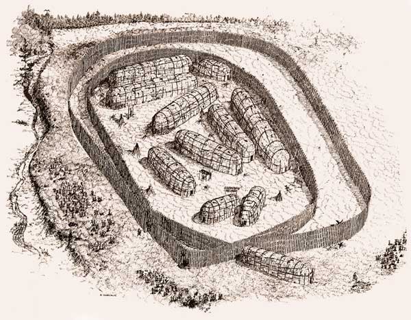
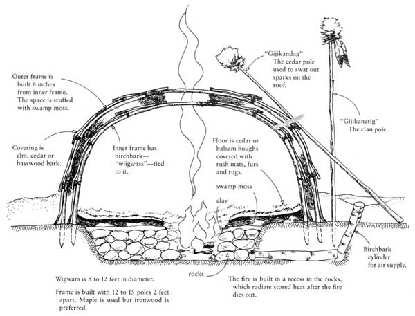
Here are some pictures of Mohawk Indian Long Houses:

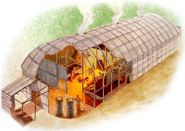
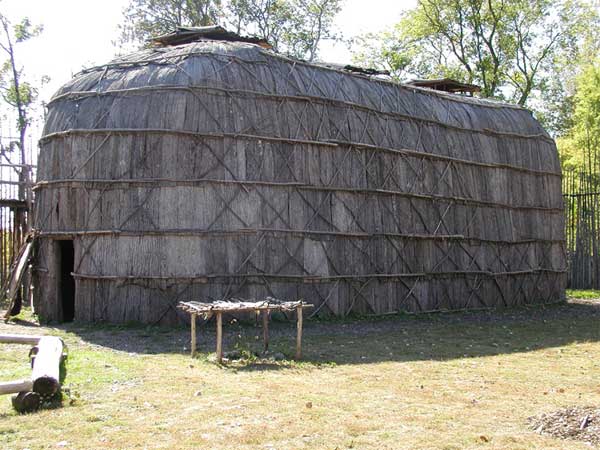
A mohawk Indian long house can be up to 300 feet long. Some may be surrounded by a fence, or by a natural barrier (like RT/KHP).
A Mohawk Wigwam would be placed in circles where they are close to each other. This was done for protection. They can be 75-200' wide in the circle. Like the one up on the east side of KHP. Wigwams were often made for temporary homes. Like what was used at North-South lake in the 1600's. Long houses were permanent homes, and often used in the Winter.
-
rkugel
- Posts: 143
- Joined: Wed Nov 25, 2009 8:54 am
Re: Brant Fort on Saturday October 30, 2010
Mike, thanks for posting photos of the long houses. Now I have a much better idea as to what they were. It is very possible that the site I located just west of Brant Fort (with the foundation) was for a long house. The area is certainly large enough to support it. Thanks again.
-
RobAins
- Posts: 2
- Joined: Mon Apr 04, 2011 7:17 pm
Re: Brant Fort on Saturday October 30, 2010
Just wondering how I go about being able to see the pics you've posted. I created an account a few weeks ago and I am still unable to see the pics! Please help!
-
rkugel
- Posts: 143
- Joined: Wed Nov 25, 2009 8:54 am
Re: Brant Fort on Saturday October 30, 2010
Hi RobAins,
What's even stranger is that not even I can view the photos I posted! Mike, would you be able to assist? I'm wondering if something hiccuped with my account.
RobAins, in case there's a problem with the site and if you wish, I can send the you the photos off line.
Mike and I have been trying since the winter to meet up and go hiking, including another visit to Brant Fort. Unfortunately, every weekend has either been busy for me, or the weather has not cooperated.
Rich K.
-
rkugel
- Posts: 143
- Joined: Wed Nov 25, 2009 8:54 am
Re: Brant Fort on Saturday October 30, 2010
Update: I just went back into the site and this time my photos rendered. Now, I'm really scratching my head.
RobAins, you may wish to try once more and see what happens. If you still have a problem, hopefully someone can help you out.
Rich K.
RobAins, you may wish to try once more and see what happens. If you still have a problem, hopefully someone can help you out.
Rich K.
-
dave

- Posts: 712
- Joined: Mon Aug 10, 2009 3:14 pm
- Location: Acra New York
Re: Brant Fort on Saturday October 30, 2010
We decided to change the view of the forum a little while back. Mainly because images were limited to the width, and the software would chop off part of the image. Now, you can post any size photo. But, for some reason, if you are not login the attached photos don't show up. I can post them on the web site if you still cannot view them. If the images just have a link, it isn't a problem. We have been working on getting this fixed. Let me know if you still cannot view them?