Unfortunately, I have been busy, so I missed the start of the post.
But, the organization of this hike didn't start out that well. We had originally planned the hike for the day after Thanksgiving. We had a full hike group of 8 people. But, due to weather concerns, we rescheduled the hike to Sunday. Once we started to talk about rescheduling the hike, it was like screaming "Bomb" in a crowded place. The hike group very rapidly disintegrated. Heather more accurately described the art of organizing a hike as like trying to herd cats. Over the next day or so, the hike group grew and shrank by each moment. On Sunday morning, we had 3 hikers and 3 dogs.
We all piled in my car and slowly headed from Devil's Kitchen over to Gillespie Road. When we arrived the PA was filled with hunters. But, I still was able to secure a premo parking spot.
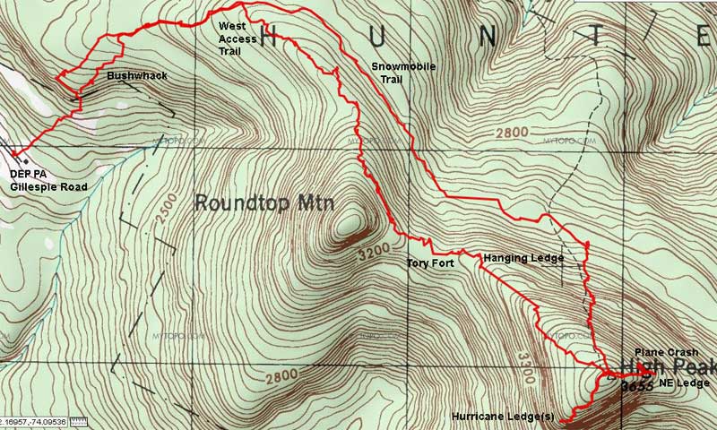
Most people have hiked KHP from the North or South side. From the west side, you can almost cross-country ski to the top. It is that gentle of a hike. If you are getting off the Catskill exit of the Thruway, just look over to KHP, and see the gentle slope to the west. That is the West Access Trail. But, the trail has many other desirable features to just add to a nice hike.
We then headed up the trail. Instead of doing the long 2 mile loop through Cortina, we bushwhacked over to the Snowmobile Trail. There is an old trail there, but very hard to follow. I usually use it as a reference. This is actually the hardest part of the hike.
Once we hit the Snowmobile trail extension to Cortina, we then hiked up to the junction. From there we walked up the north side of the Snowmobile Loop. Once at the top of the incline is the entrance to the West Access Trail.
Before I go further, it would be good if explain a little about the Kaaterskill Mtn Range and North/South Lake. Back in the 1800/1900's when the hotels are still there, there would be thousands of visitors/hikers on the trail. Locals felt overrun by obnoxious hotel people, so they often created their own hidden hiking paths. The West Access trail is one of those trail. The tradition still lives on. Standing in front of the entrance, you would have no idea that it is a trail, or has been one since the 1800's. Locals keep maintenance to the bear minimum. Falling off the trail is common. It is part of the experience and the joy of the hike. It's a trial, but it's also a bushwhack without the bush.
Once you set off down the windy and unpredictable path, you come to your first conifer forest. Unlike other conifer forest, the area is open and easy to walk through. Very peaceful. After a short walk, you exit back into Deciduous forest. After another short walk, you encounter another conifer forest. Again, it is open and peaceful. We didn't encounter any bears, but they often spend time in the conifer forest foraging. Once you exit, you will be approaching RoundTop.
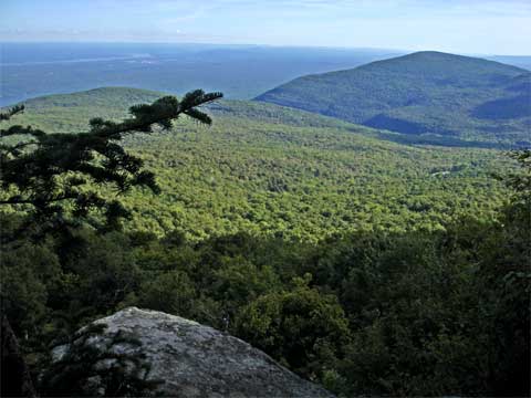
The old trail hit RT head-on. There is still a defined trail up RT on the Northwest side of the mountain. To get past RT is a challenge. The north side is filled with ledges every 50' vertical feet. The ledges are filled with car sized boulders, and littered with bear caves. We moved around to the northerly side and climbed up to a ledge around 3230'. Locals call it the 3250' ledge. There is a well defined path across it. The other ledges often end suddenly, and you have to backtrack. I think I have hiked most of them before finding the 3250 ledge. The ledge does offer some limited views over North/South Lake. You can see South Lake from the ledge. The ledges also have a lot of birds on them for those who are interested. If you stop for a moment on the ledge, you will be surrounded by them. While we were there, the dogs got excited about something below us. Probably a bear. But, he was probably 50' below us.
Once past the 3250 ledge you will start to enter the col between KHP and RT. You know you are exiting because of the leaning tree. Shortly after leaving the ledge, you will descend about 50' vertical feet into the true col.
From here, we stuck to the north side. Otherwise, you will miss the ledge where the Tory Fort is located. If you navigate it correctly, you will come upon the Tory Fort. The Tory Fort is not obvious. There are not only small bumps where the log walls once existed. The fort goes back to the late 1700's.
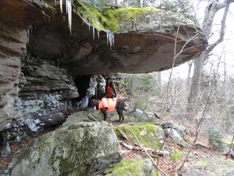
From here we pushed our way through some thicker conifer trees. Again we stuck to the northerly side. Once you leave the conifer forest, the Hanging Ledge is about 100'. It is at the head of the base of KHP. The ledge is very large. It hangs out about 20-25' and is about 6-7' high. See picture below with Bookah and Heather:
From there we headed up the gentle incline to KHP. Encountered some nice terrain. The trail is more defined here due to the traffic to RT. Once near the top, the conifers got thick. You could smell the wonderful aroma of the Balsam Firs.
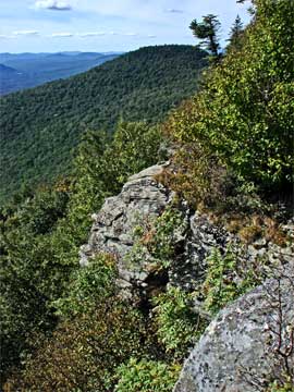
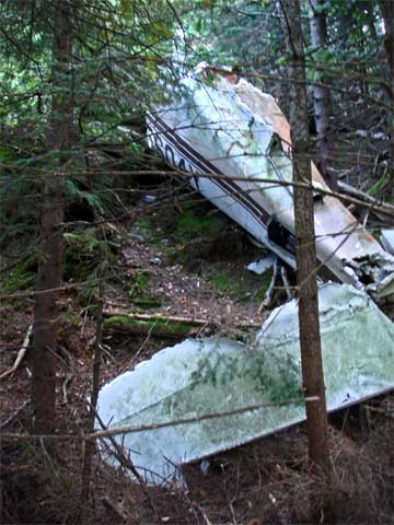
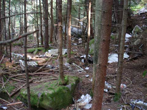
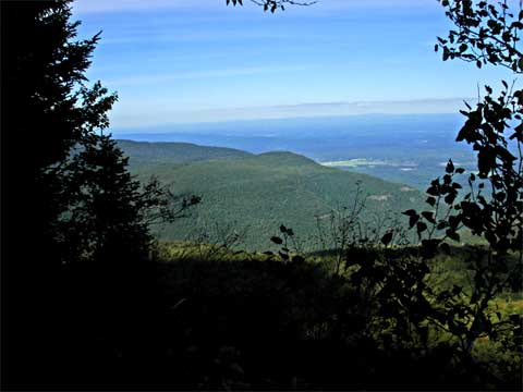
Once on top, we headed down to Hurricane Ledge. Got in some nice views and lunch. Then we discussed why someone would move the 150 lb crankshaft of the plane crash 1/4 mile down the path. It now sits near the top of the ledge. I then showed Heather the Hidden Hurricane Ledge which has a nice view of RT:
Then we headed up to the summit of KHP again. We then headed down to the NE side to see the plane crash and NE ledge.
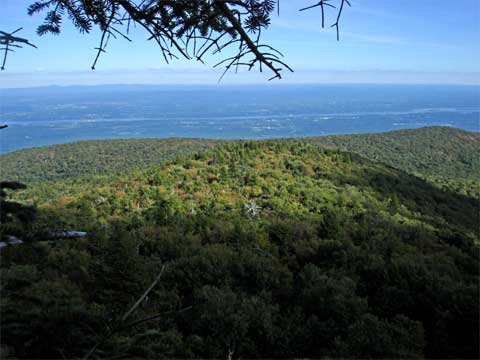
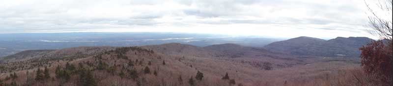
Then I took Heather down to see the NE ledge. A pretty scary small ledge. Not much room, but it has an outstanding view to the north-east-south where you can see North/South lake, Hudson River, Kaaterskill Amphitheater, Kingston, Overlook Mtn.
From here we headed down the North Access, and then headed west on the Snowmobile Trail. We then bushwhacked back to the car. We piled back in the car and headed back to Devil's Kitchen to everyone's cars.