If you want to just look at post, you do NOT need an account.
But, if you want to post comments you need to open an account. Please:
Click Here to apply for an account.

Buttermilk Ravine

Buttermilk Falls, Cortina, Devil's Kitchen, Haines Falls, Hawkeye, Huckleberry Point, Johnson's Point, Kaaterskill High Peak, Poet's Ledge, Round Top, Viola Falls, Wildcat Falls
Post Reply
User avatar
mike
Posts: 1444
Joined: Sun Aug 09, 2009 9:20 pm
Location: Ravena, NY

Buttermilk Ravine

Unread post by mike »

A couple people wanted to head up Kaaterskill Creek this weekend. But, in the end, it was just me. Instead of taking people to the common sights, I headed up a Buttermilk Ravine. I had heard that there were five waterfalls, and someone else said that there were eight waterfalls. Not sure what the real answer is. No one knew. Good reason to go.

Here is what I knew before the hike:
1. The junction of Kaaterskill Creek and Buttermilk Creek is at N42 10.927 W74 04.031, and at an elevation of 936'
2. The top of Buttermilk Falls is at: N42 10.516 W74 04.299, and at an elevation of 2186'
3. Total of 1,250' in elevation.
4. The walls around the two upper falls are 45-70 degrees, and considered a very dangerous place to hike.
5. The two upper falls at the top are reported to be over 100'.

Parked down near Fawn's Leap. Walked up to the old Tannery. I then had to backtrack quite a ways to be able to cross Kaaterskill Creek. Please Note: This hike can ONLY be done during low water. It should be done with another experienced person. I then started my hike up the Buttermilk Falls Ravine. Here are some pictures:

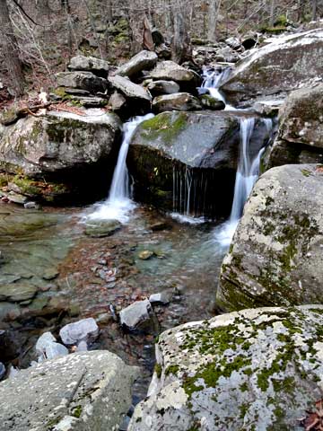
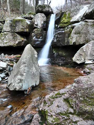
This is Waterfall #6 (last one at the junction of the creeks - 45' +-2'). We hiked up the LEFT side of the Waterfalls. At the top of the falls there is an old logging road that runs from Wildcat-to-Buttermilk-to-Santa Cruz Falls. I didn't have time to explore the old logging road completely.
Image

Here is a vertical view of the the falls. On the right side of the creek is an old trail that was probably used back in the 1800's. Please note: This trail is pretty rough. :
Image

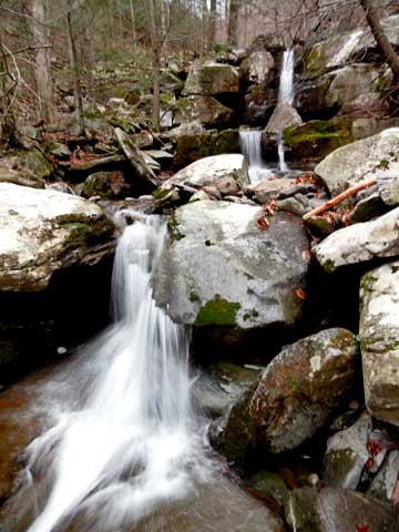
As soon as I got on top, I cross the creek. Above Falls #6, are two small cascades. Here is a picture of one of them.
Image

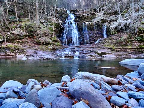
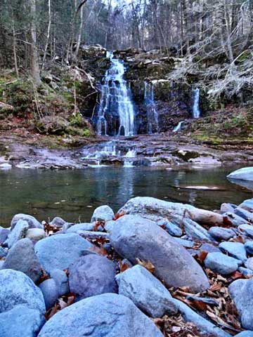
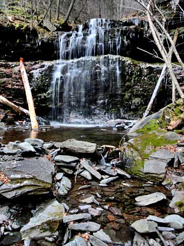
Then comes Waterfalls #5. It is a small 3-step waterfall. The next four pictures are the same waterfalls.
Image
Image
Image
Image

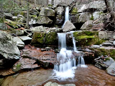
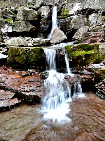
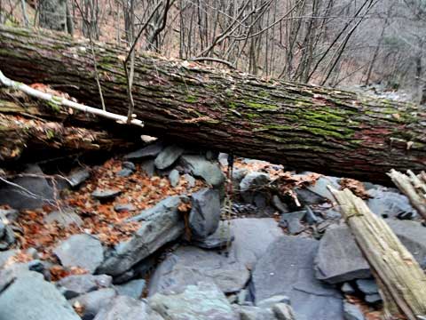
From here, you can follow the trail on the right side of the creek. At times, it climbs up the wall quite a ways. Slipping here can result in injury or death. The creek is filled with boulders and difficult to walk up. There is a trail on the left side of the stream, but it didn't seem to be better. About 1/2 way up, the banks get tough. This is waterfall #4. There are two small cascades just after this waterfall. Getting above these two waterfalls is tough. It is located at 1,598'. At this point you will start to see old growth hemlock trees. some 3-4' in diameter. The canyon walls start to get very steep. It is difficult and dangerous to get above this waterfalls. Best to be done with a partner and ropes. From this point to the top of Buttermilk Falls is 588'
Image
Image

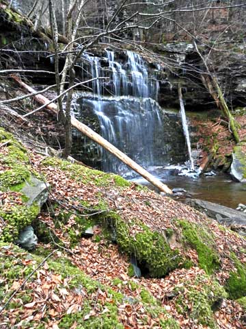
This is a view above waterfall #4. Just above the log is Waterfall #3, and the waterfall above this one is the second large waterfall #2. From our calculations, they MAY be around 200' high. From where I took this photograph, it is another 588' to the top of Buttermilk Falls. Not as high as the Five Cascades/Haines Falls, but close.
Image

At a later date, we will return to this ravine. But, hiking above this point solo was not a wise decision. Additionally, around 1500' the wet rocks had turned to ice. I believe that we can probably get to the basin of Waterfall #2 without ropes.

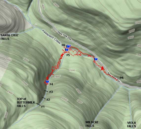
Here is a GPS map of the hike:
Image
mtnclimber
Posts: 496
Joined: Sat Oct 10, 2009 10:46 pm

Re: Buttermilk Ravine

Unread post by mtnclimber »

Mike, That is incredible! I have heard that the ravine is real difficult to hike up. Never seen pictures of the ravine. There is so much questionable material about the falls. Thanks for a good report. Hope to see more in the future.
rkugel
Posts: 143
Joined: Wed Nov 25, 2009 8:54 am

Re: Buttermilk Ravine

Unread post by rkugel »

Mike, those are awesome pictures. I'm amazed you got as far as you did. As they said on Star Trek, you "boldly went where no man has gone before"!
User avatar
mike
Posts: 1444
Joined: Sun Aug 09, 2009 9:20 pm
Location: Ravena, NY

Re: Buttermilk Ravine

Unread post by mike »

I think if I had gone above Waterfall #4, I would have gotten the most amazing picture of the upper 3 waterfalls. But, being by myself, and have KHP (west) hike the next day, I called it a day.

The ground is very soft. Very few people have walked up there in the last hundred years. It is an amazing place. You really need to see this place. Ice climbers do visit there in the winter.
User avatar
mike
Posts: 1444
Joined: Sun Aug 09, 2009 9:20 pm
Location: Ravena, NY

Re: Buttermilk Ravine

Unread post by mike »

Someone has been asking about the old-growth trees in Buttermilk Ravine. This is an old Hemlock tree that died of natural causes:

Image

My hiking poles below the log are about 4-1/2' high. I would estimate that the log is approaching 4' in diameter. I am guessing, but I might find larger hemlocks above Buttermilk #4 waterfall.
mtnclimber
Posts: 496
Joined: Sat Oct 10, 2009 10:46 pm

Re: Buttermilk Ravine

Unread post by mtnclimber »

That is some big tree! I have heard that there was some big trees up there.
dohdoh
Posts: 9
Joined: Thu Mar 03, 2011 11:20 pm

Re: Buttermilk Ravine

Unread post by dohdoh »

Hi mike,
I love these falls. I've made it up to the bottom of what you've labeled as falls number 1 hiking from the bottom with no ropes. It's definitely doable. What we've also done is hiked up Santa Cruz Ravine, bushwhacked a little bit to get to the trail that runs along the top along all the falls. The trail at the top was surprisingly well maintained and well marked with blue markers. We took that trail all the way to poets ledge, than back tracked and climbed down buttermilk falls. It wasn't an easy climb down without ropes from the top to the second, but doable. If anyone knows a better way to the bottom from either viola or wildcat, i'd love to hear about it.
I believe this is the top of buttermilk taken last fall. (It'possible it could be the top of wildcat falls, i honestly can't remember)
You do not have the required permissions to view the files attached to this post.
User avatar
mike
Posts: 1444
Joined: Sun Aug 09, 2009 9:20 pm
Location: Ravena, NY

Re: Buttermilk Ravine

Unread post by mike »

The picture looks like Wildcat, but I could be wrong. I stopped last year at Buttermilk #4 because of ice. Just too dangerous to continue. I have been told that you can get to the basin of Buttermilk #1 by going up the east side. But, it is steep and dangerous. Based upon GPS reading, we also believe that Buttermilk #2 might be the highest water fall in NYS. But, we have to get back there this Spring.

We are also looking for large first growth hemlock trees up there. We did see some below Buttermilk #4. We expect to see more above there.

Wildcat Ravine had a major mud slide last year. Didn't get a chance to get up there last year. I have been told that the best place to climb down is down the west side of Wildcat. But, there are some dangerous ledges there.

Viola Falls Ravine is very steep and it is reported that the water falls cascades down 475'. Haven't been up there in a long time.
mtnclimber
Posts: 496
Joined: Sat Oct 10, 2009 10:46 pm

Re: Buttermilk Ravine

Unread post by mtnclimber »

I have heard that Buttermilk has some man-mouth sided hemlock trees in the ravine. they say that they didn't log it because it was too difficult and steep.
Post Reply