I decided to do an "exploration" hike around North/South Lake on Saturday 11/20/2010. Being a railroad buff, I was especially interested in seeing some of the railroad artifacts in the area.
The Ulster and Delaware Railroad water tank foundation is just west of the South Lake parking area. There is also a turntable pit located about 100 feet west of the water tank.
This is the grade for the Rips Retreat Railroad, which was an amusement park ride in the 1950's. As you descend the horse trail from North Lake to the site of the Rip Van Winkle House, you will notice a raised berm to your left, which is the grade for the railroad. The railroad was less than a quarter of a mile long and ran in a circle on the ledge immediately below (i.e. east) of North Lake.
This is Puddingstone Hall, one of the favorite destinations for guests staying at the Catskill Mountain House.
This view of the Otis Elevating Railroad was taken from Eagle Rock using a 300 mm zoom lens. Eagle Rock is a few hundred feet south of the Catskill Mountain House site along the Escarpment trail. The trestle is much larger than it looks and is approximately 300 feet long and at least 30 feet high. It is accessible by hiking down the Otis railbed, although I highly recommend NOT attempting to cross it. Most of the deck is gone and the bridge is extremely dangerous.
This is the Lemon Squeezer and was located along the old trail from the Catskill Mountain House to Puddingstone Hall. There has been much confusion between the Lemon Squeezer and Elfin Pass, which is located near Fairy Spring. The two names have been used interchangeably for both sites, although period photos from this location always identify it as the Lemon Squeezer. Many thanks to Bob Guildersleeve for showing me this hard-to-find location.
This is Fairy Spring, which is an absolutely beautiful area just a few hundred feet from the Escarpment Trail. If you are walking east from the Hotel Kaaterskill site along the old carriage road, you will come to a junction where the Escarpment Trail turns right (blue markers) towards Boulder Rock and the carriage road continues straight (red markers). If you make a left (north) and bushwhack a few hundred feet, you will come to Fairy Spring. Please be advised there are numerous caves in the ledge just above Fairy Spring that could easily support bears. Please use caution while exploring the area!
This is Druid Rocks, which have to be one of the most "other worldly" sites in the Catskills. Druid Rocks are located just west of Puddingstone Hall. They remind me of the cheesy sets on the old "Star Trek" TV show where the surface of planets would be dressed with huge styrofoam rocks.
This is perhaps the most famous Druid Rock, and has been described as resembling various animals including a toad, a rabbit, and a bear.
This is what is left of the old water tank for the Catskill Mountain House. The ruins are located northeast of Puddingstone Hall.
This water tank was used by the Catskill and Tannersville narrow gauge railroad until 1918 when the railroad was abandoned. It is amazing that the tank still stands after nearly 100 years.
If you want to just look at post, you do NOT need an account.
But, if you want to post comments you need to open an account. Please: Click Here to apply for an account.
But, if you want to post comments you need to open an account. Please: Click Here to apply for an account.
Historical Hike around North/South Lake
-
rkugel
- Posts: 143
- Joined: Wed Nov 25, 2009 8:54 am
Historical Hike around North/South Lake
You do not have the required permissions to view the files attached to this post.
-
dave

- Posts: 712
- Joined: Mon Aug 10, 2009 3:14 pm
- Location: Acra New York
Re: Historical Hike around North/South Lake
Those are some great pictures Rich. Didn't know about the trestles still existed for the Otis Railroad. I will have to check them out. Are they on the upper section or the lower section? Never knew about the water tower either. Where is it located.
The picture of Fairy Springs is actually the South Mtn Bog. I think mike has some pictures of Fairy Springs. I am a little confused about the Lemon Squeezer.
Thanks for sharing.
The picture of Fairy Springs is actually the South Mtn Bog. I think mike has some pictures of Fairy Springs. I am a little confused about the Lemon Squeezer.
Thanks for sharing.
-
mike

- Posts: 1444
- Joined: Sun Aug 09, 2009 9:20 pm
- Location: Ravena, NY
Re: Historical Hike around North/South Lake
As usual, Rich finds places I don't know about. And, takes some great pictures. Really like the picture of Druid's Rock. Never got a good picture of that one.
Here is a picture of Fairy Springs from looking above during the dry season:
Here is a picture of Fairy Springs inside the spring during the dry season:
Here is a picture of Star Rock which is on the summit of South Mtn:
Here is one of my pictures of the Lemon Squeezer:
I never found Elfin Pass. But, I didn't really look that hard. I think the picture he has of Fairy Springs is actually the bog. Mike Kudish just did carbon dating and it is about 8500 years old.
Didn't know about the wood trestles on the Otis Elevating Railroad. Will have to check that out.
-
mtnclimber
- Posts: 496
- Joined: Sat Oct 10, 2009 10:46 pm
Re: Historical Hike around North/South Lake
You guys are awesome! I am going to have to check out some of these places sometime.
-
rkugel
- Posts: 143
- Joined: Wed Nov 25, 2009 8:54 am
Re: Historical Hike around North/South Lake
Hello Everyone,
Thank you so much for responding and for sharing your photos! Also, thank you for clarifying the area around Fairy Spring. I didn't realize the the bog (South Mt Bog) was actually a separate location.
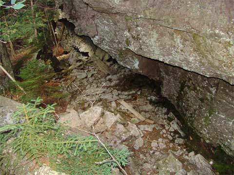
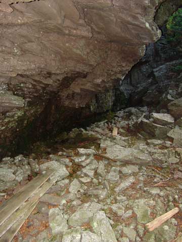
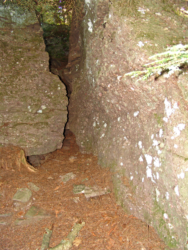
To help put things in perspective, the shot below is a companion shot to the one I posted last time. I simply turned 180 degrees and shot towards the ledge (i.e., facing east) containing Fairy Spring. Here is a shot of Fairy Spring itself, which is very similar to Mike's shot. Note the boards scattered about. Please use caution in this area. There are bears in the area and the boards have nails sticking out. This is "what I believe is" Elfin Pass (please note the quotes!) This location is about two hundred feet north of Fairy Spring and can easily be found simply by following the base of the ledge. The pass is very easily ascended. However, once at the top, the area is very overgrown and walking is difficult. I believe the path from Elfin Pass led to Star Rock. By the way Mike, your shot of Star Rock is excellent! Mike, I am also very curious about your shot of the Lemon Squeezer. It doesn't look like any of the locations I've seen. I'd be curious to see it the next time we meet up.
As I mentioned in my last post, there seems to be a lot of confusion about the Lemon Squeezer and Elfin Pass. Many publications use both names for the pass near Fairy Spring. However, there are also photos of the Lemon Squeezer from my last post, which is near Puddingstone Hall and the Catskill Mountain House. My "theory" (again, the quotes) is that the pass near Puddingstone Hall is the "real" Lemon Squeezer, while the opening near Fairy Spring is Elfin Pass. Not to play a semantics game, but I have an easier time associating an "Elfin Pass" with a "Fairy Spring" (both names convey a magical quality) than a "Lemon Squeezer". I would love to hear from someone who could definitively answer the question.
If you face east from Puddingstone Hall, you will see an old trail that curves to the north and gently descends the ledge. Once at the bottom, you will see an old trail turning to the right (east). That trail passes the Catskill Mt. House water tank ruins and proceeds to the Escarpment Trail. However, if you continue straight (north) there is another old path that quickly leads to the top of a ledge. If you descend the ledge and then turn around and look back, you will have the view of the Lemon Squeezer that I posted.
I also included a couple of additional shots of the Otis. This view was taken from Bogart Road in Palenville and looks west. Look carefully between the two power lines near the top of the photo. You will spot the same concrete trestle that I last posted. This is an "up close" shot of the trestle. I hiked down to it a couple of years ago. The concrete trestle is approximately one third of the way from the top of the Otis to the bottom at Bogart Road. Many people look at the Otis grade and think it is a relatively easy climb up the Wall of Manitou. Nothing could be further from the truth. The Otis RR was built as a series of trestles and deep cuts, in accordance with the succession of ledges from Palenville up to North Lake. The wooden trestles were all removed, but this one concrete trestle remains. Here is a shot of the Ulster and Delaware turntable pit. If you park by the South Lake parking area (which is as far as you can drive in the winter months, since the rest of the park is closed to automobiles), and then walk west a few hundred feet along the U&D right-of-way, you will see the water tank foundation and the turntable pit on your right (north) side. The Catskill and Tannersville water tank is a bit more difficult to find, though still less than a 10 minute walk. Again, park at the South Lake parking area, cross the road, and walk along the trail towards North Lake. After a couple of hundred feet, you may spot the top of the water tank through the trees. If not, leave the trail and bushwhack north. You will pass some old boarding house foundations for railroad workers and will then arrive at the Catskill and Tannersville right-of-way. From there, it should be easy to find the water tank.
I would like to wish everyone a Happy and Safe Thanksgiving. And Mike, please accept my apologies once again for not being able to join you for Friday's hike. Please have a safe and enjoyable day! Looking forward to seeing your post.
Best always,
Rich
Thank you so much for responding and for sharing your photos! Also, thank you for clarifying the area around Fairy Spring. I didn't realize the the bog (South Mt Bog) was actually a separate location.
To help put things in perspective, the shot below is a companion shot to the one I posted last time. I simply turned 180 degrees and shot towards the ledge (i.e., facing east) containing Fairy Spring. Here is a shot of Fairy Spring itself, which is very similar to Mike's shot. Note the boards scattered about. Please use caution in this area. There are bears in the area and the boards have nails sticking out. This is "what I believe is" Elfin Pass (please note the quotes!) This location is about two hundred feet north of Fairy Spring and can easily be found simply by following the base of the ledge. The pass is very easily ascended. However, once at the top, the area is very overgrown and walking is difficult. I believe the path from Elfin Pass led to Star Rock. By the way Mike, your shot of Star Rock is excellent! Mike, I am also very curious about your shot of the Lemon Squeezer. It doesn't look like any of the locations I've seen. I'd be curious to see it the next time we meet up.
As I mentioned in my last post, there seems to be a lot of confusion about the Lemon Squeezer and Elfin Pass. Many publications use both names for the pass near Fairy Spring. However, there are also photos of the Lemon Squeezer from my last post, which is near Puddingstone Hall and the Catskill Mountain House. My "theory" (again, the quotes) is that the pass near Puddingstone Hall is the "real" Lemon Squeezer, while the opening near Fairy Spring is Elfin Pass. Not to play a semantics game, but I have an easier time associating an "Elfin Pass" with a "Fairy Spring" (both names convey a magical quality) than a "Lemon Squeezer". I would love to hear from someone who could definitively answer the question.
If you face east from Puddingstone Hall, you will see an old trail that curves to the north and gently descends the ledge. Once at the bottom, you will see an old trail turning to the right (east). That trail passes the Catskill Mt. House water tank ruins and proceeds to the Escarpment Trail. However, if you continue straight (north) there is another old path that quickly leads to the top of a ledge. If you descend the ledge and then turn around and look back, you will have the view of the Lemon Squeezer that I posted.
I also included a couple of additional shots of the Otis. This view was taken from Bogart Road in Palenville and looks west. Look carefully between the two power lines near the top of the photo. You will spot the same concrete trestle that I last posted. This is an "up close" shot of the trestle. I hiked down to it a couple of years ago. The concrete trestle is approximately one third of the way from the top of the Otis to the bottom at Bogart Road. Many people look at the Otis grade and think it is a relatively easy climb up the Wall of Manitou. Nothing could be further from the truth. The Otis RR was built as a series of trestles and deep cuts, in accordance with the succession of ledges from Palenville up to North Lake. The wooden trestles were all removed, but this one concrete trestle remains. Here is a shot of the Ulster and Delaware turntable pit. If you park by the South Lake parking area (which is as far as you can drive in the winter months, since the rest of the park is closed to automobiles), and then walk west a few hundred feet along the U&D right-of-way, you will see the water tank foundation and the turntable pit on your right (north) side. The Catskill and Tannersville water tank is a bit more difficult to find, though still less than a 10 minute walk. Again, park at the South Lake parking area, cross the road, and walk along the trail towards North Lake. After a couple of hundred feet, you may spot the top of the water tank through the trees. If not, leave the trail and bushwhack north. You will pass some old boarding house foundations for railroad workers and will then arrive at the Catskill and Tannersville right-of-way. From there, it should be easy to find the water tank.
I would like to wish everyone a Happy and Safe Thanksgiving. And Mike, please accept my apologies once again for not being able to join you for Friday's hike. Please have a safe and enjoyable day! Looking forward to seeing your post.
Best always,
Rich
You do not have the required permissions to view the files attached to this post.