Mike, thanks again for such a great day. I really hope we can do this hike again in the next few weeks.
Mike's post pretty much covered it all, but I'd still like to share the notes that I gathered from our hike:
On Saturday 09/11/2010, Mike and I finally had schedules that coincided allowing us to hike together. We met at the end of Gillespie Road around 10:00 am and hiked the West Access Trail to Round Top and Kaaterskill High Peak. For details of the route we took, please refer to the full description for the West Access Hike to KHP that is posted on this site in the “Hiking” section.
Mike’s GPS and excellent sense of direction allowed us to bushwhack directly to the Snowmobile “spur” trail that goes to Cortina. Referencing the Snowmobile trail can be confusing since there are really three components to the Snowmobile trail system:
1. The “main” loop trail that encircles Kaaterskill High Peak and Round Top
2. The spur trail that runs west from the loop and accesses the former Cortina ski area
3. The short connector that runs north from the loop and joins the Long Path.
2010-0911-SnowmobileTrail-Fix.jpg
Once on the Snowmobile spur trail, we turned right (east) and walked a short distance to the junction with the Snowmobile loop trail. From there, we veered left (north) and proceeded for approximately a quarter of a mile to where the West Access trail begins. The entrance is marked by a tree shaped like a wishbone. In all honesty, I could not discern any hint of a trail, but Mike was able to spot it from having hiked it multiple times.
The West Access trail is a truly beautiful walk through the woods, and it is a crying shame that it is not a marked path so that everyone can enjoy it. Except for a few scrambles up rather steep ledges, the trail is a very gentle ascent up Round Top and (later on) up to Kaaterskill High Peak. A few observations about the trail:
1. Although the trail is fairly obvious in some areas, in others areas it completely disappears. Consider this hike to be a bushwhack – period.
2. Do not try this trail if you have a poor sense of direction or if you are not comfortable with bushwhacking. From the point of entrance, it is two and a half miles until the summit of KHP. If you get hopelessly lost, it will be very difficult for anyone to find you.
3. It is amazingly easy to walk off the trail. Mike and I fell prey to losing the trail more times than we could count. Mike taught me a valuable skill in these circumstances which is to hike in a broad zigzag pattern until you re-acquire the trail.
4. Making things more difficult (or easier, depending on your point of view) is that the trail seems to have been relocated in many areas. Consequently, there are often two parallel trails that are usually separated by 50 to 100 feet.
5. You will frequently run into cleanly cut branches and saplings – apparently the work of hikers who are intimately familiar with the trail and are trying to maintain it. These cut branches are the next best thing to markers and were a tremendous help towards assuring us that we were on the trail.
6. By far, the biggest challenge is finding the “3250 Ledge” by Round Top. After ascending a series of ledges, you will be tempted to follow your intuition and continue straight along the north rim of Round Top with yet another high ledge to your right (south). Resist the temptation (!) as this path leads to a dead end! Instead, turn to your right, walk a short distance (25 to 30 feet) along the base of the ledge, and then jog to your left and ascend the ledge through a steep (but not difficult) opening. Once at the top, you will be at the 3250 foot level. Turn left and walk a few steps. You will soon acquire the trail, which will be very obvious at this point. Congratulations! You’ve just survived the most difficult part!
2010-0911-WestAccess-Entrance-Fix.jpg
Mike and I crossed Round Top and dropped into the col between Round Top and KHP and were determined to locate the Tory Fort (which Mike had successfully located in 2009). Unfortunately, Round Top played a mean trick on us and completely hid the fort. We searched in vain for an hour but could not find it! Of course, neither of us had the presence of mind to bring the coordinates, which could have been uploaded into Mike’s GPS, making the quest a breeze. Oh well, there’s always next time!
On the other hand, we discovered a vague woods road gently descending from the col in an easterly direction. Mike and I suspect that the road may have been used to bring horses and supplies up to the fort. We both agreed that we need to explore that road some time.
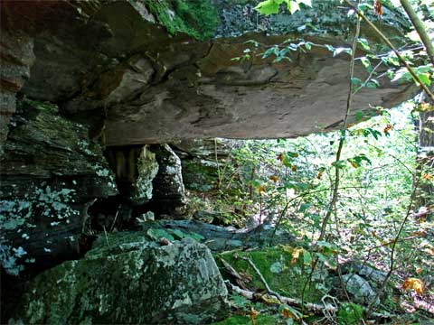
However, the biggest prize of the day was at the eastern end of col, just before the ascent to KHP. Mike and I found the “Hanging Ledges”. There are two ledges, though the northerly “hanging ledge” is far more spectacular than its “little brother” just to the south. As mentioned earlier, the West Access trail has undergone several relocations. One of these relocations is by the hanging ledges. One trail runs to the north of both ledges while another trail runs between them.
The northern “Hanging Ledge” is truly awesome. There is an enormous slab of rock extending at least 20 feet out over a cave-like area. The slab probably weighs in the area of 100 tons – almost the equivalent of a train locomotive! Mike posed by the hanging ledge to provide some perspective. Mind you, Mike is well over 6 feet tall, though he is totally dwarfed by the massive formation. When the West Access trail was in frequent use, there is no doubt that these hanging ledges were the highlight of the hike.
2010-0911-HangingLedge1-01-5-Fix.jpg
2010-0911-HangingLedge1-02-Fix.jpg
2010-0911-HangingLedge2-01-1-Fix.jpg
Mike and I continued our bushwhack to KHP and came out almost exactly at the summit. The trail becomes very vague near the summit. In fact, we came out several feet away from where we both agreed the West Access trail actually joins the north-south trail over the summit. Somehow we drifted, but no matter! One point of note is that the West Access trail becomes very narrow near the summit and you have to squeeze through a thick conifer forest. Unlike deciduous branches that are, for the most part, soft and flexible, conifer branches are rigidly hard and VERY sharp. You can easily incur a serious puncture wound if you are not careful.
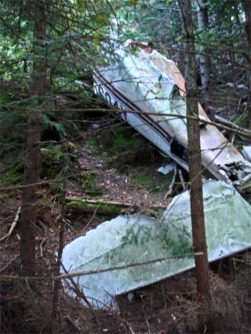
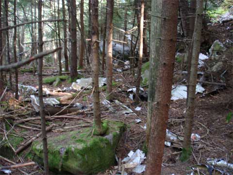
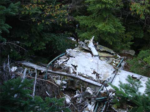
From the summit, we drifted down to Hurricane Ledge and met two other hikers (John and Paul) who asked us for the best route back to the Platte Cove Parking area. We advised them to descend KHP via the south access, then follow the Snowmobile trail to the “lower” plane wreck (KHP has two plane wrecks) and then bushwhack to the Long Path.
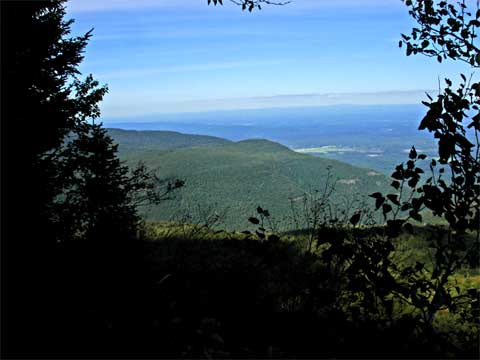
2010-0911-HurricaneLedge-01-1-Fix.jpg
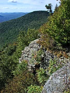
All four of us enjoyed the view from Hurricane Ledge while Mike and I had lunch. After a much-deserved rest, we bushwhacked from Hurricane Ledge a short distance west to a spectacular lookout featuring a grand view of Round Top. Extreme caution is required at this ledge. You must “slither” your way under low trees and brush and then lower yourself down a steep rocky incline to a tiny ledge. Only one person at a time can safely stand on the ledge (“safely” being a relative term in this case).
2010-0911-HurricaneLedge-02-1-Fix.jpg
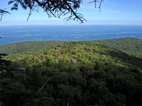
From Hurricane Ledge, Mike and I said “good-bye” to John and Paul. Mike and I then returned to the summit and explored the “upper” plane wreck and the spectacular view from another ledge located about 200 feet from the wreck on the east side of KHP.
2010-0911-KHP-PlaneWreck-01-3-Fix.jpg
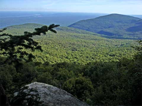
2010-0911-KHP-SummitLedge-Fix.jpg
By this time, it was nearly 4:30 pm and Mike and I realized that we really needed to leave and return to our cars while there was still light. We crossed the summit one more time, and then descended the north access trail to the Snowmobile trail. From there, we turned left and followed the Snowmobile trail back to where the West Access trail departed. From there, we retraced our steps from earlier in the morning and arrived back at our cars around 6:30 pm.
Mike and I had a great day and the weather was gorgeous – clear skies, low humidity, and temperatures in the 60’s – perfect weather for hiking!
We want to revisit this area in the coming weeks not only to locate the Tory Fort (which eluded us this time), but also to explore the summit of Round Top. As Mike mentioned, anyone interested is welcome to join us.
2010-0911-KHP-NorthTrail-01-2-Fix.jpg
You do not have the required permissions to view the files attached to this post.