Hurricane Sandy
Posted: Thu Oct 25, 2012 11:27 am
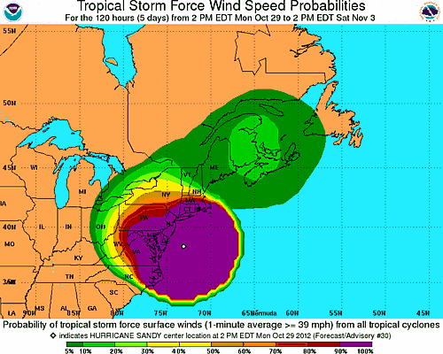
Oct 29 - evening: With the projected path of Hurricane Sandy we believe that the Catskill Mountains will receive approximately 4-5 inches of rain, and winds of 35-40 MPH with gust to 65 mph. Mountain Peaks will receive winds over 100 mph. Especially on the Eastern Escarpment. The Eastern Escarpment will receive very high winds, and may have the highest waterfall amounts. Peaks: Overlook Mountain, Kaaterskill High Peak, Stoppel Point, Blackhead will be at very high risk. There will be very high winds moving directly from the east into the Eastern Escarpment. This is how Hurricane Ledges are created on Kaaterskill High Peak. Monday night (between 5pm and 2am) will be the peak of winds and waterfall. Since the ground is already saturated with water, there will be more flooding then you will expect. Different regions of the Catskill Mountains will receive different amounts of rain fall and winds. This storm will stall and linger for up into Friday. But, most of the storm will pass by Wednesday morning.
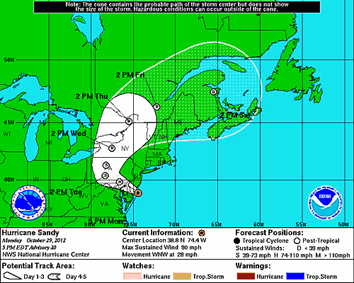
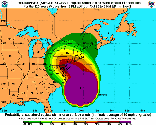
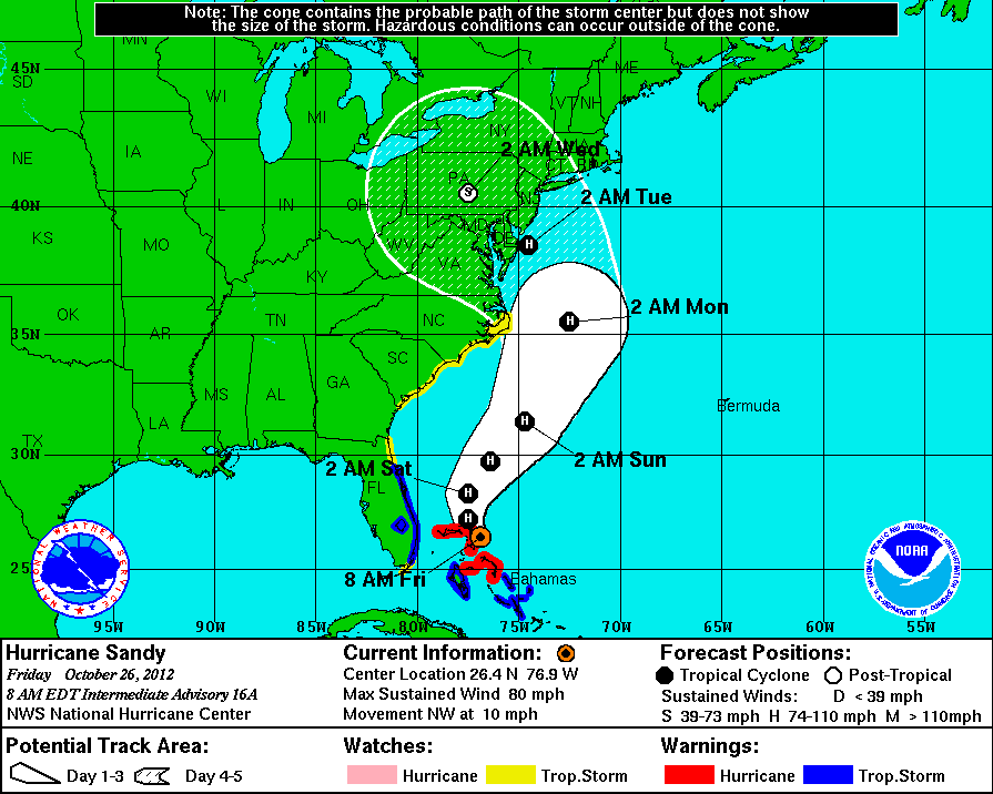
Oct 28 - evening: With the projected path of Hurricane Sandy we believe that the Catskill Mountains will receive approximately 4-5 inches of rain, and winds of 35-40 MPH with gust to 65 mph. Mountain Peaks will receive winds over 100 mph. Especially on the Eastern Escarpment. The Eastern Escarpment will receive very high winds, and may have the highest waterfall amounts. Peaks: Overlook Mountain, Kaaterskill High Peak, Stoppel Point, Blackhead will be at very high risk. There will be very high winds moving directly from the east into the Eastern Escarpment. This is how Hurricane Ledges are created on Kaaterskill High Peak. Monday night (between 5pm and 2am) will be the peak of winds and waterfall. Since the ground is already saturated with water, there will be more flooding then you will expect.
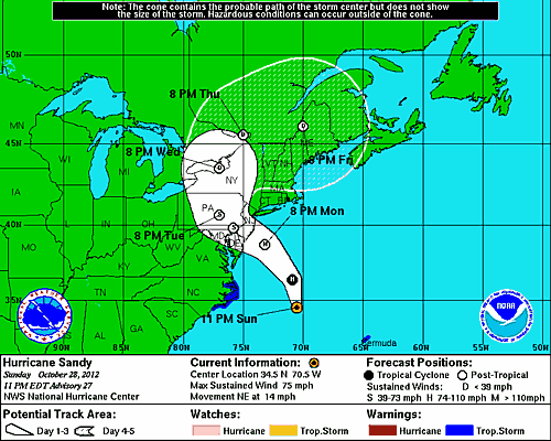
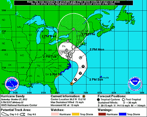
Oct 27 - evening: With the projected path of Hurricane Sandy we believe that the Catskill Mountains will receive approximately 5 inches of rain, and winds of 20-30 MPH with gust to 45 mph. The wild card of this hurricane is that it will be combining with an existing storm in an approaching cold front. NOAA has never see this type of condition, so predictions are difficult. You should continue to check back for future forecast.
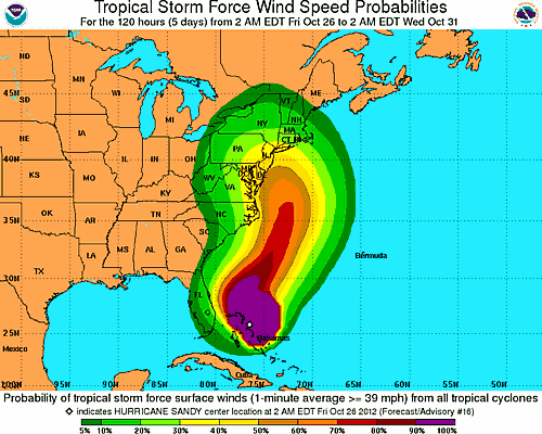
Oct 26 - morning: What a difference 12 hours make. The new projected path of Hurricane Sandy has moved almost 200 miles south. Right now it is projected to come ashore between Maryland and Delaware on Tuesday morning. This doesn't mean that we are out of the woods on this storm. The path could easily change before next Tuesday. We will still get several inches of rain and wind. But, it doesn't look like it will be another Hurricane Irene. Western regions of the Catskill Mountains should receive more of an effect of the hurricane then the eastern side. Right now, it doesn't look like it will be snow or change to snow. Stay tuned, because this could change completely.
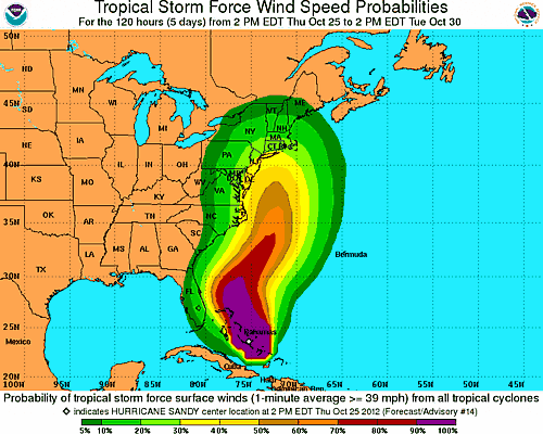
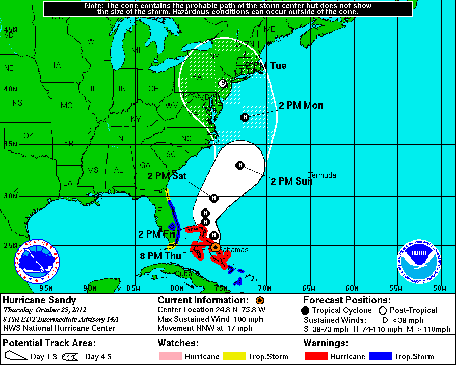
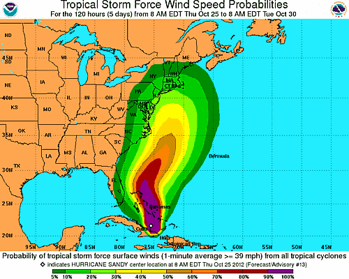
Oct 25 - evening: Meteorologist are now predicting that the Hurricane Sandy will come on-shore around NYC and move upward. This hurricane is expected to move very slowly which will dramatically increase the amount of rain and wind damage. They are expecting this to be a 5-day event instead of a 1-day event like Hurricane Irene. The potential that Hurricane Sandy being worse then Hurricane Irene is very possible. They are expecting over 1 billion dollars in damage. Locations north and west of the hurricane may see snow instead of rain. It is possible that the Catskill Mountains may get 10-15 inches of rain. With the ground already saturated, this could cause significant water damage. Meteorologist are calling this a very scary storm. If you plan on hiking the coming weekend, you should plan on being out earlier then normal.
Oct 25 - morning: Right now it looks like the Catskill Mountains might be affected by Hurricane Sandy. They are expecting it to arrive anywhere from Monday to Wednesday next week. If you are going to be out hiking this weekend, make sure you keep up to date on Hurricane Sandy. Maybe we'll get nothing, but maybe we'll then hit hard. The water level is already up fairly high. We don't need more water right now. Stay tuned for more updates.
Oct 28 - evening: With the projected path of Hurricane Sandy we believe that the Catskill Mountains will receive approximately 4-5 inches of rain, and winds of 35-40 MPH with gust to 65 mph. Mountain Peaks will receive winds over 100 mph. Especially on the Eastern Escarpment. The Eastern Escarpment will receive very high winds, and may have the highest waterfall amounts. Peaks: Overlook Mountain, Kaaterskill High Peak, Stoppel Point, Blackhead will be at very high risk. There will be very high winds moving directly from the east into the Eastern Escarpment. This is how Hurricane Ledges are created on Kaaterskill High Peak. Monday night (between 5pm and 2am) will be the peak of winds and waterfall. Since the ground is already saturated with water, there will be more flooding then you will expect.
Oct 27 - evening: With the projected path of Hurricane Sandy we believe that the Catskill Mountains will receive approximately 5 inches of rain, and winds of 20-30 MPH with gust to 45 mph. The wild card of this hurricane is that it will be combining with an existing storm in an approaching cold front. NOAA has never see this type of condition, so predictions are difficult. You should continue to check back for future forecast.
Oct 26 - morning: What a difference 12 hours make. The new projected path of Hurricane Sandy has moved almost 200 miles south. Right now it is projected to come ashore between Maryland and Delaware on Tuesday morning. This doesn't mean that we are out of the woods on this storm. The path could easily change before next Tuesday. We will still get several inches of rain and wind. But, it doesn't look like it will be another Hurricane Irene. Western regions of the Catskill Mountains should receive more of an effect of the hurricane then the eastern side. Right now, it doesn't look like it will be snow or change to snow. Stay tuned, because this could change completely.
Oct 25 - evening: Meteorologist are now predicting that the Hurricane Sandy will come on-shore around NYC and move upward. This hurricane is expected to move very slowly which will dramatically increase the amount of rain and wind damage. They are expecting this to be a 5-day event instead of a 1-day event like Hurricane Irene. The potential that Hurricane Sandy being worse then Hurricane Irene is very possible. They are expecting over 1 billion dollars in damage. Locations north and west of the hurricane may see snow instead of rain. It is possible that the Catskill Mountains may get 10-15 inches of rain. With the ground already saturated, this could cause significant water damage. Meteorologist are calling this a very scary storm. If you plan on hiking the coming weekend, you should plan on being out earlier then normal.
Oct 25 - morning: Right now it looks like the Catskill Mountains might be affected by Hurricane Sandy. They are expecting it to arrive anywhere from Monday to Wednesday next week. If you are going to be out hiking this weekend, make sure you keep up to date on Hurricane Sandy. Maybe we'll get nothing, but maybe we'll then hit hard. The water level is already up fairly high. We don't need more water right now. Stay tuned for more updates.