Hurricane Irene
Posted: Thu Aug 25, 2011 10:31 am
If you have information or pictures, please Email us at: irene@catskillmountaineer.com
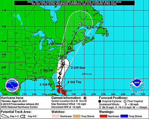
Hurricane Irene is coming our way. Projected models show it's most probably path coming up eastern-to-central Connecticut. Another model shows it coming up the Hudson Valley as a Cat 2 hurricane. The most severe damage occurs on the western side of the hurricane. This means the eastern escarpment of the Catskills can have winds over 100+ MPH. This is exactly how the hurricane ledges on KHP were created. I cannot overemphasize the dangers of this hurricane. This may be the most powerful hurricane to hit the Catskill Mountains since November 28, 1950. There was two other damaging hurricanes in November 8-10, 1913 or October 22-25, 1923. Typically, hurricanes like Hurricane Irene can product anywhere from 5-15" of rain. Expect massive flooding.
The most dangerous areas will be: Windham High Peak, Acra Point, Blackhead Mountains, Stoppel Point, North Mountain, North-south lake, KHP, Plattekill Mountain, Indian Head Mountain, and Overlook Mountain. Anywhere along the eastern escarpment will be dangerous. The higher the elevation, the higher the winds. KHP and Blackhead may receive winds from 100-150 MPH (even with 50 MPH winds in the valley). Higher peaks will put you into the jet stream.
NOTICE: YOU SHOULD BE OUT OF THE WOODS BY NOON-TIME ON SATURDAY, AUGUST 27th! IF YOU HIKE ON SATURDAY, MAKE SURE YOU HIKE WITH OTHER PEOPLE. IF YOU ARE CAUGHT OVERNIGHT, YOU MAY BE KILLED BY FLYING DEBRIS OR FALLING TREES. WE CANNOT OVEREMPHASIZE THE DANGERS OF THIS HURRICANE!
UPDATE (08/27): NYS DEC is now recommending that people NOT hike on Saturday or Sunday. They too are predicting massive flooding, rain, and high winds.
UPDATE (08/28): The eye of the storm should pass east of Catskill Mountains around 2PM on Sunday. Rain fall totals should exceed 10+ inches of rain. Expect major flooding and many road closures.
