If you want to just look at post, you do NOT need an account.
But, if you want to post comments you need to open an account. Please: Click Here to apply for an account.
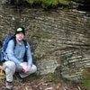
So I did a project for my water resources class on the Neversink basin and what happened in Frost Valley during Hurricane Irene. I got a lot of shots of how the West Branch of the Neversink actually rerouted itself, and is now a braided stream which runs on two levels, and joins up again, then splits again.
Got about 160 shots up there, with some maps to correspond with the trip. Not gonna post all of them here, but I went all the way to the top of Slide, and down the other side a bit.
Cool pictures, interesting stream stuff. I love the picture of the Ashokan Reservoir, very crisp detail. Hiking is always extra exciting when projects are thrown in. Last summer I did line transects and vegetative analysis on the slopes and summits of Slide, Hunter, and the Blackheadz for my biogeography thesis. I cheated a bit on Blackhead- some parts of my line were impenetrable. Have you visited the Rondout Creek? The Rondout got hit very hard, and some parts of the middle section between Sundown and Peekamoose, around the camping areas, got braided and rerouted through wooded sections of the camping fields. I noticed that in areas were soil was completely washed away, the glacier till rocks that were revealed were very similar in size and weathering to rocks that were in the main stream bed (this was also the case in Arkville, the rocks revealed were houses got washed away were water weathered rocks, much smoother than the ubiquitous Catskill glacial till)... as if possibly it is only in recent centuries or immediate millennia that water ceased to flow through the wider stream gorge of the Rondout and other valleys. Or, they were just so weathered by the Peekamoose Gorge glory days that a shorter amount of time with intense melt-surge equals thousands of years of stream weathering action.
It looks like you hit some ice. One day after you were there, I hiked the 9, much less ice.