If you want to just look at post, you do NOT need an account.
But, if you want to post comments you need to open an account. Please:
Click Here to apply for an account.

New USGS Topo map section

Discussion of anything else that doesn't fit into the other forum categories.
User avatar
dave
Posts: 712
Joined: Mon Aug 10, 2009 3:14 pm
Location: Acra New York

New USGS Topo map section

Unread post by dave »

After 8 months of work, we have added a new USGS topo map section. We have added 750 mb of maps. You can now get histroic, current, and high-resolution USGS topo maps of the entire Catskill Mountains.

Image

You can check it out here: http://www.catskillmountaineer.com/USGS.html
mtnclimber
Posts: 496
Joined: Sat Oct 10, 2009 10:46 pm

Re: New USGS Topo map section

Unread post by mtnclimber »

How about a USGS map with trails on them.
User avatar
kennykb
Posts: 241
Joined: Tue Apr 24, 2012 11:19 pm
Location: Niskayuna, NY
Contact:

Re: New USGS Topo map section

Unread post by kennykb »

mtnclimber wrote:How about a USGS map with trails on them.
How about such a thing, indeed? I surely think it would be nice!

In fact, I think it's nice enough that I have a project that I'm working on in my nonexistent spare time.

I'm not really ready to reveal it to the world, but the group here is small and friendly enough that I think I can show it for a while, and then take it down again while I'm working on it. Hie yourself over to

http://kbk.is-a-geek.net/catskills/test ... 74.15&z=13

and have a look. The settings that are given will start you up with an overview of the Blackhead Range, but you should be able to pan and zoom to anywhere in the Catskills or Hudson Highlands.

There are a few prety bad map rendering glitches, and some data problems, and I don't want to put it up for real because I have some legal hurdles to clear. But this should give a feel for what I'm working on with it. I welcome comments. I'll leave it up for a week or two to let the folks here have a chance to see it.

For what it's worth, I've also been experimenting with getting that map into my GPS-equpped phone and using it even when out of cell range. It seems to work pretty well using Backcountry Navigator on my Samsung. And, as far as I know, nobody else has a decent Catskill trail map in electronic form.

Progress on this project will be slow because I'm easily distrac... hey, let's go hiking!
I'm not lost. I know exactly where I am. I'm right here.
mtnclimber
Posts: 496
Joined: Sat Oct 10, 2009 10:46 pm

Re: New USGS Topo map section

Unread post by mtnclimber »

Looks like a fun project you got going on there. I think I have seen something like this before. Looks like the tracks from the NYS GIS site. I think that there is a software package that will load it onto your phone. The NYNJTC sells their maps for it.

There are rumblings of a full USGS topo map with all the trails on it, along with the non-official trails and noteable locations. A couple other people have been talking about another map, like VO Maps.
User avatar
mike
Posts: 1442
Joined: Sun Aug 09, 2009 9:20 pm
Location: Ravena, NY

Re: New USGS Topo map section

Unread post by mike »

there are a lot of map projects proposed. Most people now want to see where those unofficial trails are.

The project looks nice.
bikenhike
Posts: 134
Joined: Sat Apr 03, 2010 5:53 pm

Re: New USGS Topo map section

Unread post by bikenhike »

Nice to have a place to download them when needed.
User avatar
kennykb
Posts: 241
Joined: Tue Apr 24, 2012 11:19 pm
Location: Niskayuna, NY
Contact:

Re: New USGS Topo map section

Unread post by kennykb »

Sorry about the delay answering, I've been on the road in California for the past week.

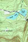
mtnclimber is right that the NYSGIS trail data is one of the data sources. I also used a large set of shapefiles for the New York state parks that I got from Andy Arthur (who got them on a Freedom of Information request from the NYS Office of Parks, Recreation and Historic Preservation). I've been trying to integrate what few trails are on Open Street Map, as well as some corrections of my own (fixing the misalignment between Balsam and Haynes, for instance).

The water features are from NHD and the USFWS wetlands inventory. The topography is from NED. Roads, railroads, airports, towns, and landmarks are Open Street Map. The public land boundaries are from NYSGIS. The lean-to's, trail registers, fishing sites, boat launches, and so on are from another file that Andy got from DEC under Freedom of Information. (The parking lot locations in that file are all messed up, by the way.) I'm sure there are more data sources that I'm forgetting, I'd have to look at my programming to see what else I've put in there.

There are indeed software packages for getting this stuff into a GPS-equipped phone. The one I've been using is called MOBAC (MOBile Atlas Creator) -- http://mobac.sourceforge.net/. It can interface with quite a variety of map packages on the phone: the one I've been using is Backcountry Navigator, and so far it's been reasonably satisfactory.

I'm surely not trying to compete with NYNJTC here, but at this point I can't use their maps, because they're only for Apple. I'll probably buy some of them when they come out for Android, but right now this map is about the best I can do. As others have observed, the USGS maps don't have most of the trails. I did this project mostly for my own use, but I'm always willing to share.

Obviously, I have no official data sources for the unofficial trails. But if people have data, I'll be happy to look into including it. Probably the easiest way would be for people to get their trail data into Open Street Map, and let me pull it from upstream. (Actually, in a few places, like Bear Mountain/Harriman, I do have some of the unofficial trails; apparently, whoever put the files together there saw fit to include some of the old woods roads and unmarked trails.)

If this winds up going anywhere and I can clear the legal issues, I'll try to look into making it available for wider download. Right now, my available bandwidth won't take it. My current working map covers New York State south of the Mohawk and east of Binghamton (with the exception of eastern Long Island), and it's about 6 gigabytes. This stuff always gets into slinging an ungodly amount of data.
I'm not lost. I know exactly where I am. I'm right here.
User avatar
mike
Posts: 1442
Joined: Sun Aug 09, 2009 9:20 pm
Location: Ravena, NY

Re: New USGS Topo map section

Unread post by mike »

The NYS GIS information is inaccurate. But, it gives you a pretty good set of tracks. Good enough for what you are trying to do.

I wouldn't worry about the NYNJTC mobile project. I don't think you are trying to compete with them. You are doing this on a different level. For you, it looks like a cool little project that you are having fun with. It is the direction of the future. It is going to take some time for the hardware to catch up with the software. Some phones go berserk trying to find a signal and wear the battery down quickly.

The unofficial trails are hard to get. There are many trails out there. Probably more unofficial places then official trails. there has been talk of collecting as many as possible. It would be a long and difficult job to get them all.

You might want to talk with Liz Cruz. She has done a number of maps of the Catskills. She has some professional grade software for making maps.

It is nice looking project.
User avatar
kennykb
Posts: 241
Joined: Tue Apr 24, 2012 11:19 pm
Location: Niskayuna, NY
Contact:

Re: New USGS Topo map section

Unread post by kennykb »

If I'm using my phone as a GPS, I always run it in airplane mode, with the screen as dim as I can read it, and with as many features disabled as I can get away with, to save the battery. Last time, I got in the better part of two days hiking, recording tracks all the way, on about 2/3 of a battery charge. In airplane mode, it won't be trying to find a signal, so that power drain is accounted for.
I'm not lost. I know exactly where I am. I'm right here.
mtnclimber
Posts: 496
Joined: Sat Oct 10, 2009 10:46 pm

Re: New USGS Topo map section

Unread post by mtnclimber »

Didn't know about the airplane mode. Great tip!
Post Reply