While I'll agree with mike that there might be some bugs, my overall experience with my garmin unit has been pretty good. I won't go to the extent that people should be fired LOL, but there are some odd things that happen. Mine is a few years old (Garmin Etrex Venture HC) I have never updated my unit's software, and from reading Mike's post I don't plan on it!
I noticed that mine does not always show the correct reading on trip odometer while hiking. It can sometimes be 20% lower than the actual mileage when I download the GPS track to mapsource. (example 5 mile gps track in Mapsource will only show up as 4 miles in trip computer on unit) Still don't know why this is. I haven't really investigated that much. I am used to the discrepancy and calculate for it. I know I've gone 20% further than my unit says I have. I don't have a thermometer on my unit so I can't say anything in that regard.
My unit has no problems starting hikes like Mike describes. I clear data before every hike, and I download the track after every hike. I don't have that much RAM so I don't store much on there except the waypoints for all the summits and whatever map tiles I've got on there (see pic below). When I start a hike it takes about 2-3 minutes to link up to satellites, and it does this the best when stationary and not in a valley (and most catskill hikes start out in valleys). I usually will turn it on and clear data right when I get to a parking area, and by the time I've got my gaiters on it's got Satellite link up.
I definitely agree with Mike, that the most useful screen is the trip computer. Why would they do away with this? I use the trip computer screen the most while hiking to see the elevation, time hiked, the moving time/resting time, average MPH, and all that. But without the trip computer just a silly little line on the screen and the topo doesn't help all that much during a hike. (except when you're lost lol) If the garmin doesn't have the trip computer I would not get it.
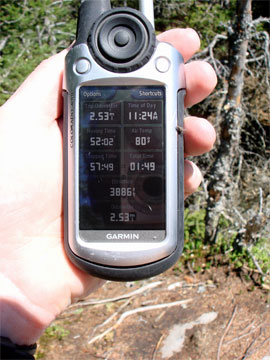
Two most asked questions "how far have we gone" and "how much further/ how long until we get there" nothing but the trip computer screen can give you the answers to these. Here is a shot of my HC's trip computer, my unit is fairly smaller than Mikes. I think that smaller is better, I throw it in my camera bag and forget about it most of the time.

(If you're wondering about the Max speed it's a track from my last bike ride)
I don't really print out my hikes, but the Garmin Software interacts seamlessly with Google Earth and I usually transfer my GPS tracks over to .kmz files so that I can email them to people I went hiking with or upload them to my website.
(you can view them all here) Then anyone can download those .kmz files (For Google Earth) and view the hike in 3D. It's all fairly easy, and I have so many papers around my house that digital copies are a better idea for me than map printouts.
Before you go wasting money on topo maps from garmin check out this Free website:
http://www.gpsfiledepot.com/maps/state/all
These are topo maps for basically every single region. I highly recommend them since they are very accurate and are
freeware so you don't have to pay an arm and a leg every-time you want to travel to a new region of the country. Most are 20 foot contours but some are 50 foot contours.
Here is a sample of my GPS track of Kaaterskill High Peak hike overlayed on the NYtopo from that website with 20 ft contours. I have not seen what you get from Garmin for the money they charge, but for people like me who don't have a lot of disposable cash this is a great alternative.

Yes there is a limit on the amount of maps that you can have on the unit. It depends on the Kilobytes of RAM and the size of the map files. For instance, these are the map tiles that I currently have on my unit (pink shading):

You can see it holds the 4 tiles for the Catskills plus I put an extra one on there for the Mass hike I did 2 weeks ago. I also have 2 tiles for NJ on there. That's it though my unit doesn't have any more RAM so when I go to the Adirondacks I usually delete these maps and load different ones on there. It's all very easy and there are good help files with the garmin software. My unit does not have a microSD slot, so I just need to be mindful before I hike that I have the correct Topo set downloaded to the unit.
My unit takes 2 AA batteries and I use the
Energizer rechargable and it will last about two hikes or one weekend trip on one set of batteries, but I always have a few extras in my pack. I don't think it matters if you get one with built in rechargeable battery, other than it might last longer if they are lithium ion.