Huckleberry Point |
 |
| |
| |
|
OVERVIEW |
| | Distance: | 4.58 miles round trip from DEC parking lot to Huckleberry Point and back. |
| | Time: | Average 3.0 hours round trip |
| | Elevation Gain: | 644' feet from parking lot to highest point in hike. |
| | Best Time to Hike: | Anytime. Morning will provide light into the Plattekill Clove which enhances your view. |
| | Difficulty: | Easy |
| | Peak Elevation: | 2,545' |
| | |
| | | USGS Official Map: | Kaaterskill Topographical Map (free) |
| | |
| | | DEC Trail Map: | DEC Kaaterskill Wild Forest Map (free) |
| | |
| | | Digital Mapper: |
Topo
Terrain
Satellite |
| | |
| | | Access Methods: | Foot, snowshoe, and snowmobile (part way). Very good snowshoe trail. |
|
|
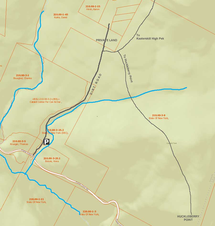
Maps |
 |
|
 |
|
|
| | DIRECTIONS TO TRAIL HEAD |
| | DEC Parking Lot WGS84 (DEC): 42.133667, -74.0827 - Elevation is approximately 1,872 feet |
| | DEC Parking Lot Deg/Min/Sec: N42 08 01, W74 04 57 - Elevation is approximately 1,872 feet |
| | DEC Parking Lot GPS: N 42 08.020, W 74 04.962 - Elevation is approximately 1,872 feet |
| | DEC Parking Lot UTM: 18N 575810 4665024 - Elevation is approximately 1,872 feet |
| |
|
| | Take New York State Thruway to Exit 21 (Catskill). |
| | Take a left out of the NYS Thruway entrance road. |
| | Go approximately 1/2 mile |
| | Take a right onto Route 23 West |
| | Go approximately 5 miles on Route 23. |
| | Take a left onto Rt 32 (McDonalds on corner). |
| | Go approximately 7-8 miles on Route 32. |
| | Take right onto Rt 23A. |
| | Go approximately 7-8 miles on Rt 23A . |
| | When you come into Tannersville, take LEFT at the red light onto RailRoad Ave (Rt 16), which will turn into Spruce Street, which will turn into Platt Clove Road. Follow this road approximately 7-8 miles |
| | The DEC parking lot is on the LEFT side of the road. |
| | It is approximately 1/2 mile past Josh Road (on left side of the road). |
| | If you start to go down the hill to the valley, then you have gone too far. The downhill section of the road is closed in the winter. |
| | Do NOT block the gate entrance - there is a house at the end of this road. |
| | Do NOT drive up the dirt entrance road to the trail head - this is PRIVATE property - AND there is NO place to park or turn around once you get to the trail head. |
|
|
NOTES ABOUT THIS HIKE |
| | This is a fairly easy hike compared to other hikes in the Catskill Mountains. The hardest part of the hike is crossing Hell's Hole Creek. When it has not rained in a while, most hikers find it easy to cross. But, after a significant rain storm, the water can be 1-2 feet deep in spots. Some hikers might venture further up Hell's Hole Creek until they find a good spot to cross.
The ledges at Huckleberry Point have some significantly high ledges, and this poses a significant risk to small children.
The views at Huckleberry Point are excellent. There is almost 180 degree view. Considering that this is a fairly easy hike, it provide a significant amount of enjoyment for the casual hiker.
There is an unofficial trail by Huckleberry Point, call the Huckleberry Quarry Trail. There is significant exposure to high ledges near the point. The trail can be difficult to follow in certain sections. There are a couple places where people tend to get lost. The Huckleberry Quarry Trail comes out in the middle of Platte Clove. This trail is used mostly by local hikers.
There are NO huckleberries at Huckleberry Point or anywhere in the Catskill Mountains. There are some blueberries bushes around Huckleberry Point. Huckleberries look exactly like blueberries. But, they taste much better then blueberries. Huckleberries can only be found in the Western part of the United States in very small patches.
Near Huckleberry Point is a small grove of Pitch Pine trees, which are fairly rare in the Catskill Mountains. |
|
|
MILEAGE CHART |
| |
Mile Point |
Altitude |
Notes |
| | 0.00 | 1,872' | DEC Parking Lot. |
| | 0.89 | 2,366' | Road & Trail Junction - On Right side of road - easy to miss this junction |
| | 1.01 | 2,412' | Trail Junction - Left goes to Kaaterskill High Peak - Right goes to Huckleberry Point |
| | 1.28 | 2,325' | Hell's Hole Creek |
| | 2.29 | 2,226' | Huckleberry Point |
| | 4.58 | 1,872' | Return to Parking Lot |
|
|
Hike to Huckleberry Point from Platte Clove Parking Area |
 |
The image above is the entrance to the Upper Platte Clove DEC Parking Lot. This is also the old Steenburg Road. Presently, you can only travel by motorized vehicle up to the DEC Parking Area. You are NOT allowed to drive past the gates!
The Upper Platte Clove Parking Area does fill up fast during the summer months and on some weekends. Make sure you park so that other cars will have a placed to park.
Do NOT park on the side of Platte Clove Road (Rt 16). Your car WILL be towed by the Town of Hunter!
Across the street are two parking spaces for access to Hell's Hole. If you drive past Steenburg Road on Platte Clove Road, there is another parking area around the corner called the Bridal Veil Lookout Parking area, which is now CLOSED to public parking. Further down Platte Clove Road (Rt 16) is Middle Platte Clove Parking Area for the unofficial Huckleberry Quarry Trail (2 parking spaces). Near the bottom of the clove is the Lower Platte Clove Parking Area (1 space) for access to Platte Clove.
|
|
 |
This is the sign for the DEC Upper Platte Clove Parking Area on Rt 16 in Platte Clove.
|
|
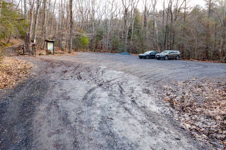 |
After a short drive up Steenburg Road, you will come to the Upper Platte Clove Parking Area. Make sure you park so that other cars will have a placed to park. |
|
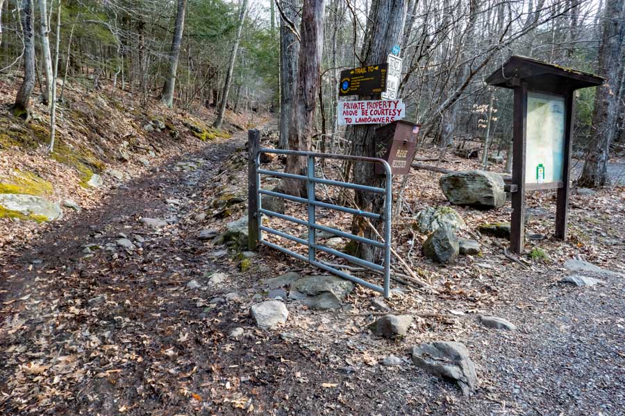 |
This is the Trailhead for Kaaterskill High Peak and Huckleberry Point. You cannot drive past this gate. Only the landowner and emergency vehicles can drive past the gate. Further up Steenburg Road, the land will cross over into private land.
If a vehicle comes up or down Steenburg Road, please move over so that they can get past.
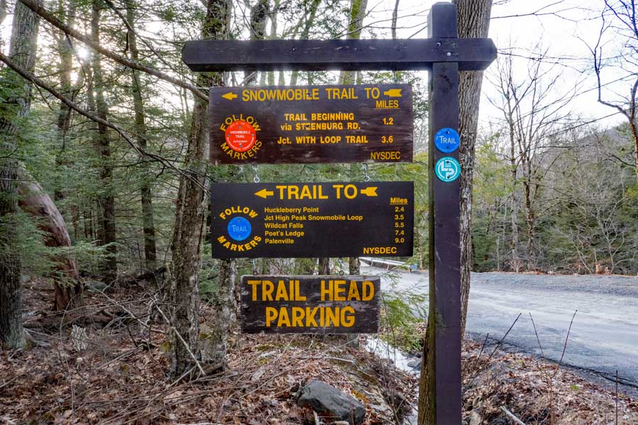
Make sure that you register for your groups hike here. Registering allows more money for trail maintenance, enlarging the parking area, and allocation of funds for this area. Furthermore, if you get lost, the Rangers will use this information to find you. |
|
 |
 |
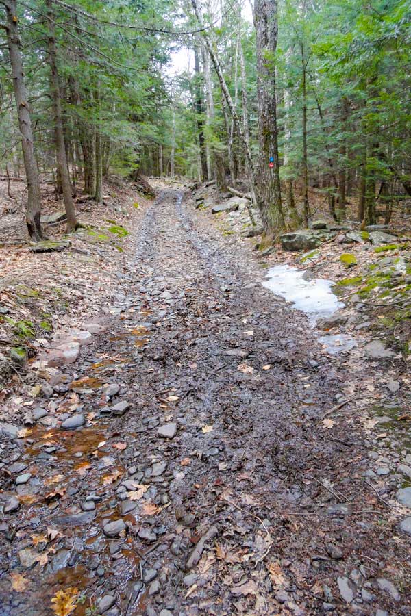
The picture on the LEFT show a picture of the trail (Steenburg Road) after the Trail Head. The beginning of the trail is the steepest part of the road. |
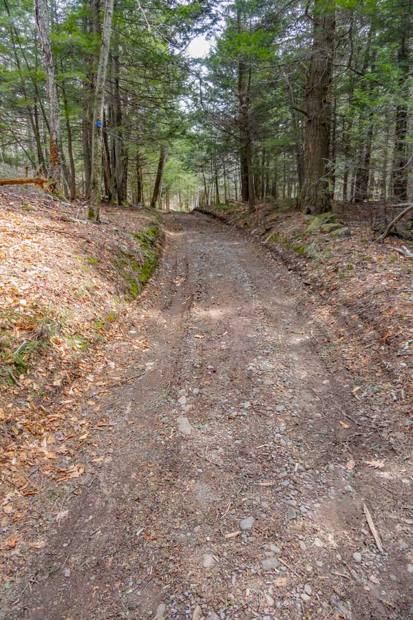
As you get further up, the incline of Steenburg Road becomes more level, and easier hiking. |
|
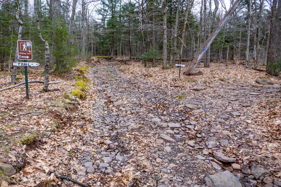 |
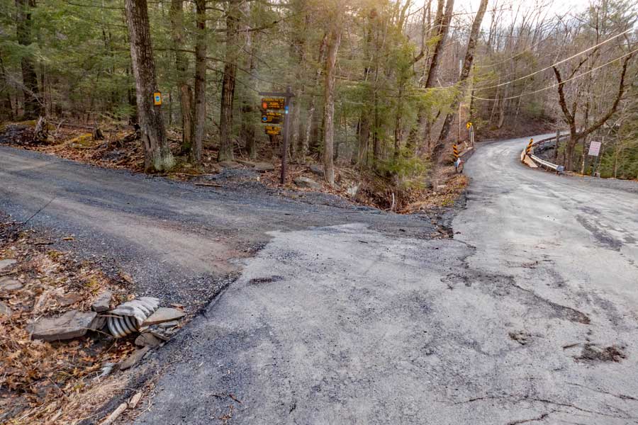
After a little less then 9/10 of a mile, you will leave Steenburg Road. Take a RIGHT at this point and follow the trail another 1/10 of a mile until you reach the trail junction for Huckleberry Point. |
|
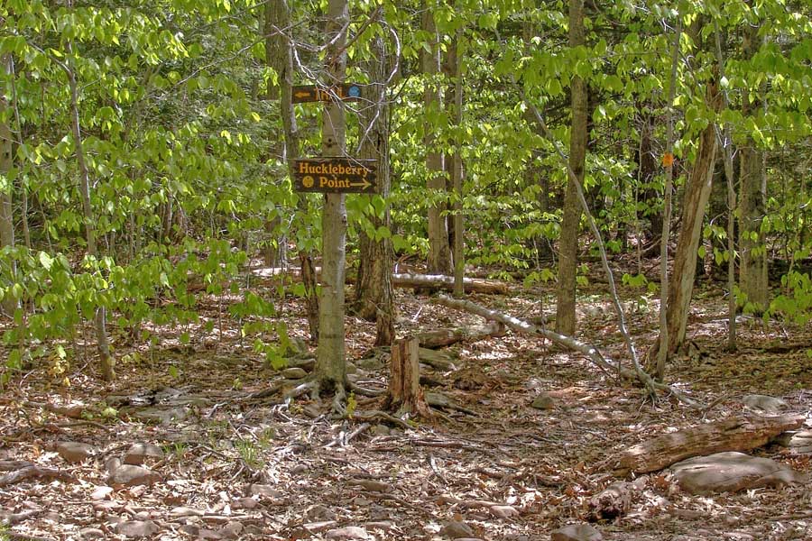 |
After a little more then 1/10 of a mile, you will come to a trail junction. You want to go RIGHT towards Huckleberry Point (Yellow Trail markers). Left goes towards Kaaterskill High Peak (Blue Trail Markers). |
|
 |
 |
The trail starts off with an easy downhill path for about a little less then a 1/3 of a mile. |
The hardest part of this hike is crossing Hell's Hole Creek. In the dry summer months, it is usually easy to cross. But, after significant rain storms it can be difficult. |
|
 |
 |
After crossing Hell's Hole Creek, the trail starts to go uphill at a fairly easy incline for about 200 vertical feet before descending back down. |
After going down the hill, the trail is fairly flat until you reach Huckleberry Point. |
|
 |
This is the view from Huckleberry Point looking directly south. |
|
 |
This is the view looking southeast from Huckleberry Point. You can see the Hudson River, Saugerties, and Kingston from this point. |
|
 |
This is the view looking west from Huckleberry Point.
Once you are done, reverse your course back to your car. |
|
|
S E C T I O N S
|
W E A T H E R
|
O T H E R
|