|
Camping & Hiking at Trout Pond |
 TROUT POND TRAIL
 |
 |
Next to the Trout Pond Trailhead is the Russell Brook Road Parking Area.
The DEC Registration Box is next to the Kiosk. Make sure you register for your hike. If you are injured or lost, Rangers will use this information to find you quicker. The more people who register, the more money is allocated for maintenance of the trails at this trailhead.
|
|
 |
This is the Trout Pond Trailhead, that is just below the parking area. This trail will take you to both the middle and upper trailhead of Trout Pond Trail.
|
|
 |
About 500 feet past the Trout Pond Trailhead is a heavy-duty bridge over the Russell Brook. It can be quite icy when the temperatures are near or below freezing. If the temperatures have been near or below freezing make sure you bring microspikes.
|
|
 |
About 150 past the trail junction to heavy-duty bridge, is an unmarked trail on your RIGHT. That unmarked trail will take you to the base of lower Russell Brook Falls. The Russell Brook Falls are 150 feet from the Trout Pond Trail. Some consider this one of the highlights of this hike.
You can see the upper part of Russell Brook Falls from Russell Brook Road.
|
|
 |
After another 600 feet, you will come to another trail junction. You want to continue STRAIGHT.
Left is the middle Trailhead for the Mud Pond Trail. This trailhead is for middle section of Mud Pond. Campsite #1 is about 300 feet down Middle Mud Pond Trail.
|
|
 |
After another 1/4 mile, you will come to the second Trail Junction. You want to go RIGHT, and up the hill.
Left would take you up to a Campsite #2 in approximately 500 feet. Some hikers take the campsite spur thinking it is Trout Pond Trail. Unfortunately neither trail has trail markers at the trail junction.
|
|
 |
The Trout Pond Trail will climb about 200 feet in elevation before you reach the foot of Trout Pond.
|
|
 |
This is the foot of Trout Pond. There is a concrete dam that control the height of the water in Trout Pond.
If you cross the concrete dam, you will go to Campsite #3 on the southwestern side of Trout Pond. Beware that the water flowing over the dam is slippery. It often has algae on the concrete.
|
|
 |
 |
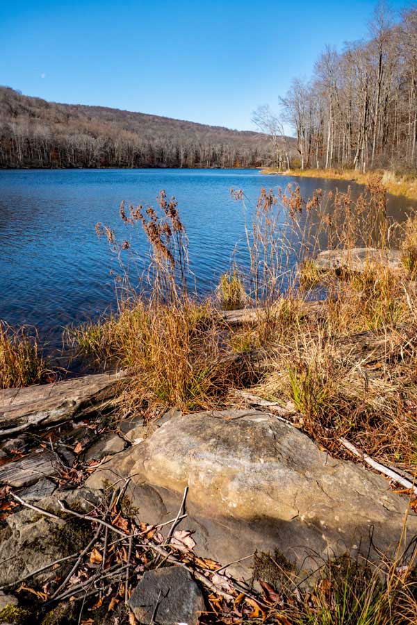
This picture was taken about half way up Trout Pond |
The Trout Trail follows the edge of Trout Pond, and provide nice views as you hike up to the head of the pond. |
|
 |
This wooden bridge is near the head of Trout Pond (northeaster end). Campsite #4 is on the right side of the trail and near the bridge.
|
|
 |
When you arrive at northeastern side of Trout Pond you come to several trail junctions. At this Trail Junction is Lean-to #1 which is called the Northern Trout Pond Lean-to.
If you are going to Lean-to #2, or the last two campsites (Campsite #5 and #6), go LEFT.
Straight is a continuation of the Trout Pond Trail, which will take you far away from Trout Pond.
|
|
Trout Pond CAMPSITES |
 |
This is Campsite #1. It is located about 300 feet west of Trout Pond Trail on the Middle Trout Pond Trailhead.
|
|
Trout Pond CAMPSITES |
|
This is Campsite #2. It is located about 1/4 miles north of the Middle Trout Pond Trailhead.
|
|
 |
This is This is Campsite #3. It is located near the foot of Trout Pond on the Southwestern side of Trout Pond.
|
|
 |
This is This is Campsite #4. It is located on the northeastern side of Trout Pond near the wooden bridge and trail junction to Lean-to #1 and the continuation of Trout Pond Trail.
|
|
 |
This is Lean-to #1. It is located on the northeastern side of Trout Pond. You can easily see the Northern Trout Pond Lean-to from the trail junction.
|
|
 |
This is Lean-to #2. It is located on the northwestern side of Trout Pond.
If you hike past the outhouse, you will find Campsite #5 and Campsite #6.
|
|
| |
S E C T I O N S
|
W E A T H E R
|
O T H E R
|

